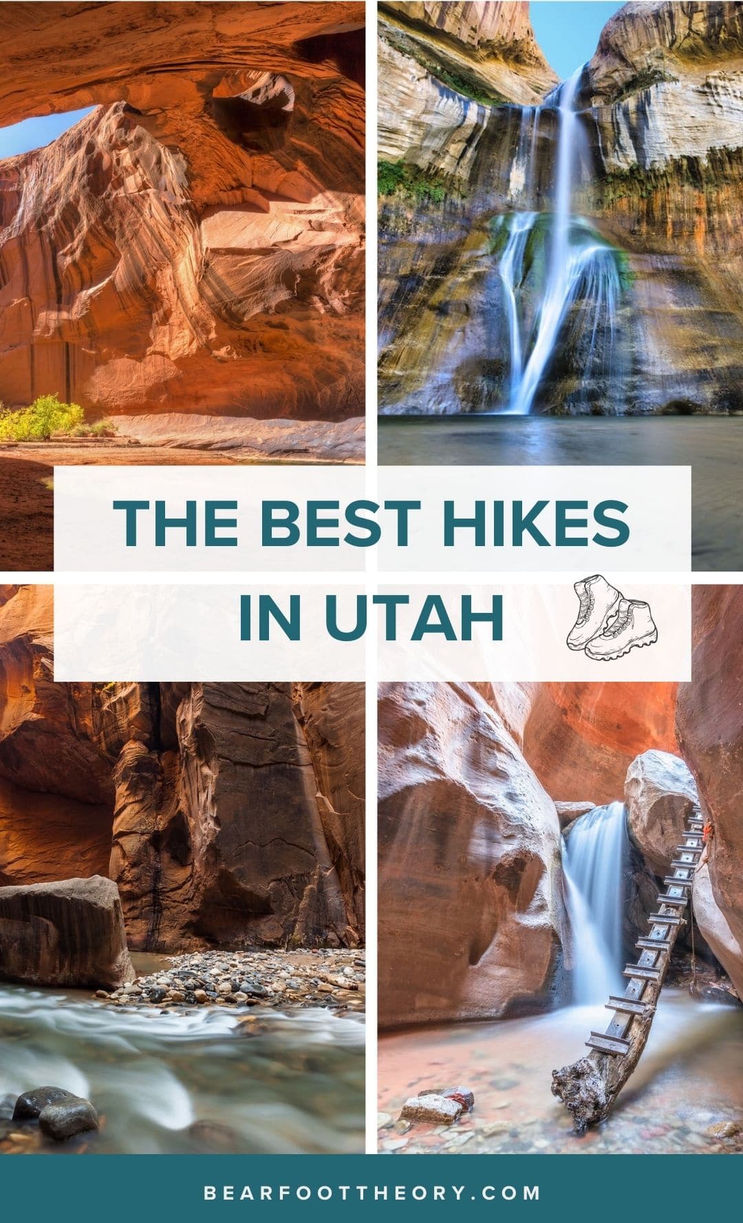
Best Hikes in Utah: 20 Epic Trails – MAPPED!
A round-up of the best hikes in Utah! Get tips for exploring these bucket list trails from Utah’s National Parks to SLC’s highest peaks.
I moved to Utah back in 2015 when I discovered that this beautiful state offers some of our country’s best hiking, most unique landscapes, and four seasons of outdoor recreation.
Whether you want to bag one of Salt Lake City’s 12,000-foot peaks, hike the world-famous trails in Utah’s Mighty 5 National Parks, or you want to find peace and quiet in the remote Southern Utah desert, Utah has literally thousands of trails to explore.
If you’re like me, the endless list of Utah trails makes it difficult to narrow down how to spend your time here. So to help you out, I’ve rounded up a list of the best hikes in Utah I’ve discovered over the last several years, along with a few that are still on my Utah hiking bucket list.
Of course, there are many trails I have yet to explore, so if there is something I’m missing, make sure to leave a comment at the end of this blog post!
Plan your Utah adventure now with this list of the best hikes in Utah.
This post may contain affiliate links.
Map of the Best Utah Hikes
Our favorite Utah hiking trails detailed below are all marked on this map. Click the icons on the map to get more info on each point of interest.
Save this post!
Enter your email & I'll send this post to your inbox! You'll also receive my weekly newsletter full of helpful advice for planning your adventures.
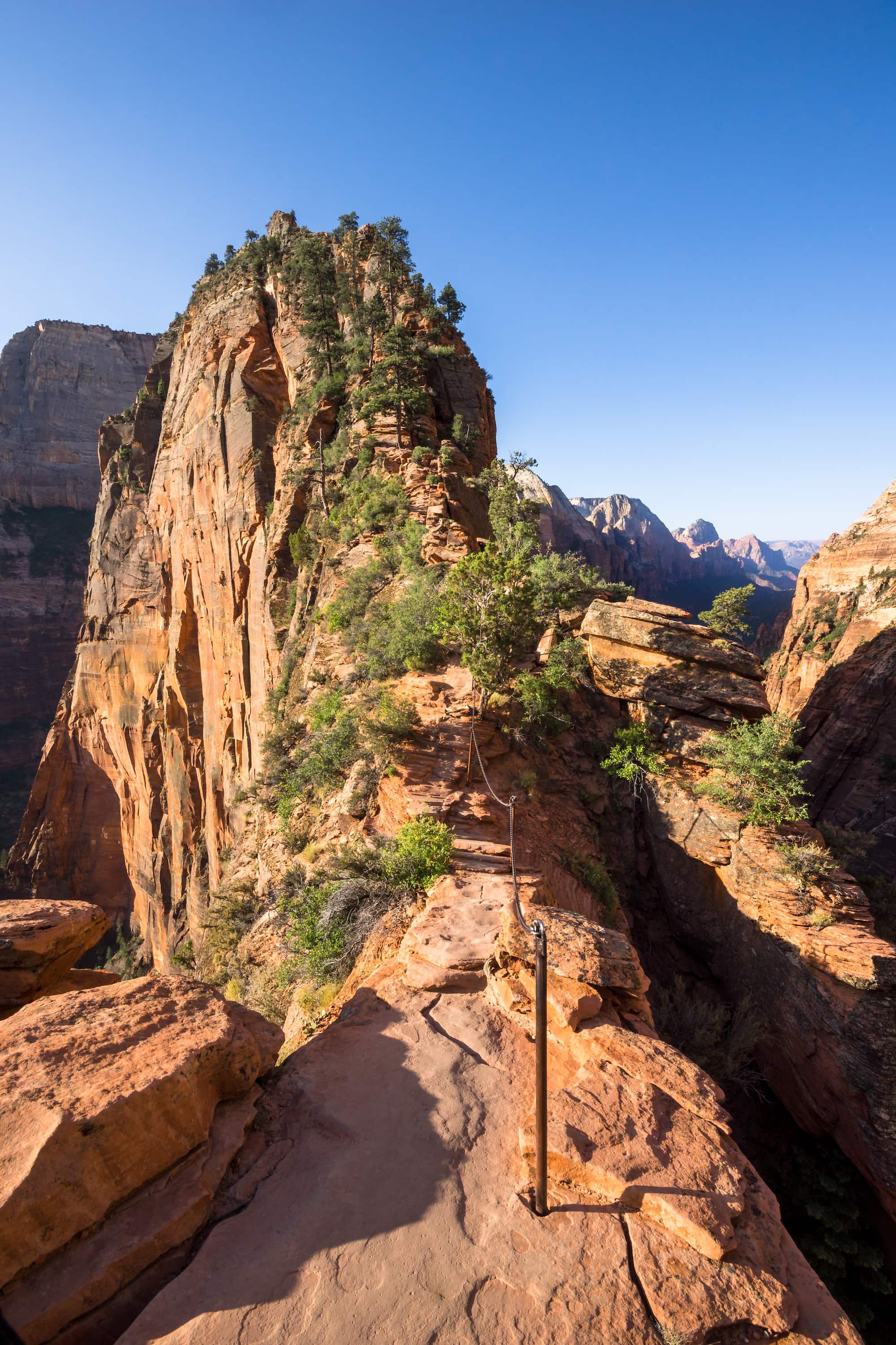
1. Angel’s Landing, Zion National Park
- Length: 4.1 miles
- Elevation gain:1,617 feet
- Difficulty: Strenuous
- Permit: Yes (new as of 2022)
First, on our list of best hikes in Utah, Angel’s Landing is a beautiful hike that’s known for being the most popular hike in Zion National Park. To avoid crowds, try not to visit during the busy season and hike at non-peak hours, like very early in the morning or late in the afternoon (don’t forget your headlamp!).
This hike begins with a series of switchbacks that travel up Zion Canyon, eventually spitting you out at the base of Angel’s Landing. Those with a fear of heights might consider stopping here. Beyond this point, the trail gets very exciting, turning into a steep and narrow path with chains to hold onto as it drops off on either side, eventually opening up to 360-degree views.
Starting on April 1st, 2022 everyone who wants to hike Angel’s Landing will need a permit. Permits are available via a lottery system two months in advance and you can pick up to 7 ranked days and times for your hike. There is a $6 non-refundable fee to apply for a permit and an additional $3 fee if you are issued one. Find more information about the Angel’s Landing permit process and apply for your permit on the Zion National Park website.
How to get to Angel’s Landing
Within Zion National Park, Angel’s Landing trailhead is easily accessible from The Grotto trailhead shuttle stop in Zion Canyon. For more information on getting to Zion National Park & staying nearby check out our Essential Zion National Park Guide.
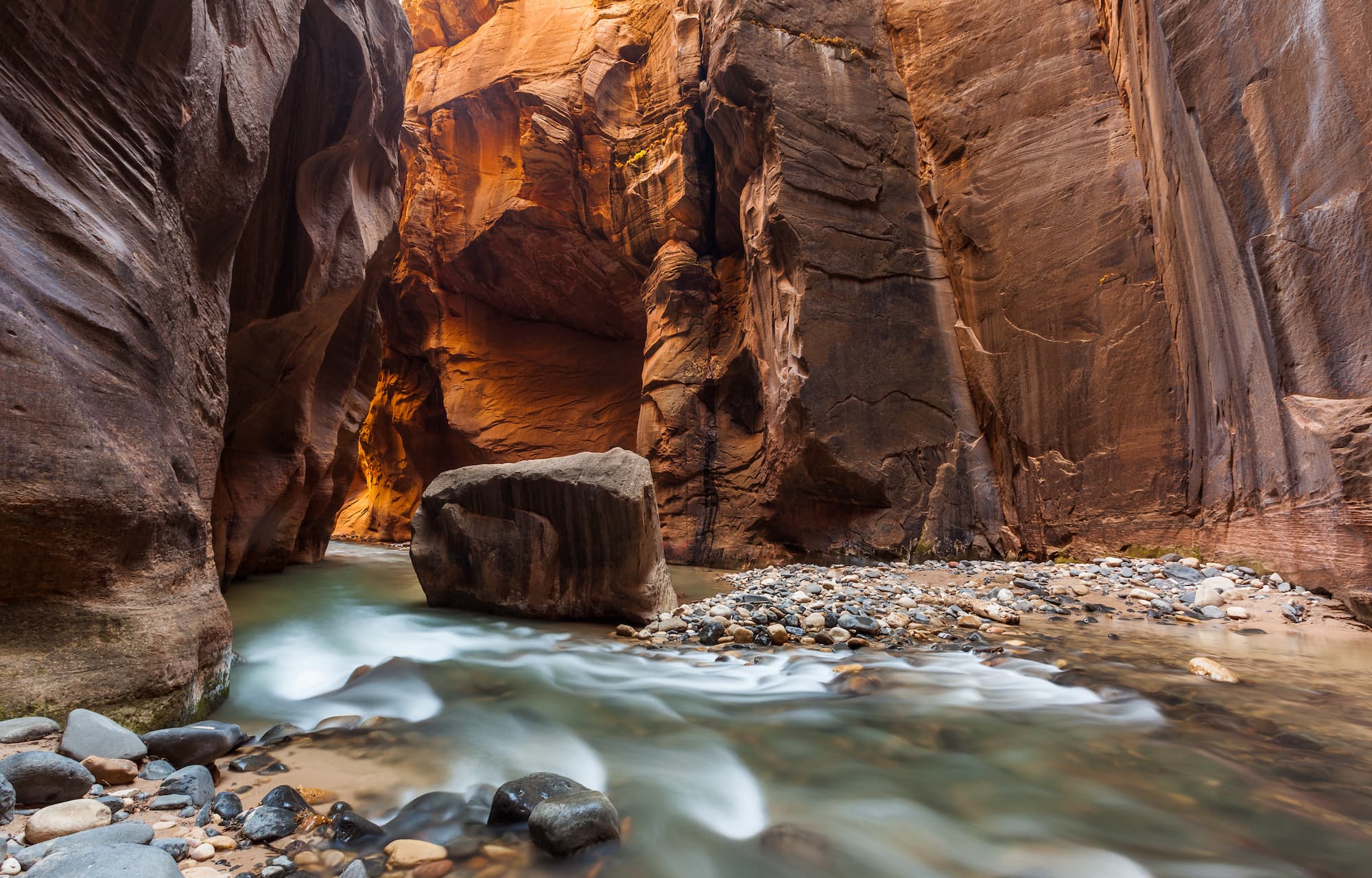
2. The Narrows: Top-Down + Bottom-Up Hike, Zion National Park
- Length: 5 or 16 miles
- Elevation gain: 206 -1,017 feet
- Difficulty: Easy to Strenuous
- Permit: Not needed for Bottom-Up; Permit needed for Top-Down Hike
- Days: 1 for day hike / 2 for an overnight backpacking trip
Zion National Park is also home to another best hike in Utah: the world-famous Zion Narrows. This is the narrowest section of Zion Canyon where you walk right in the Virgin River between two cliffs that reach heights of 2,000 feet on either side. There are dozens of beautiful swimming holes and at the narrowest point, the canyon is just a few feet wide.
You can hike the Narrows as a day-hike from the bottom-up via Riverside Walk (no permit required and you turn around whenever you want), but I highly recommend doing the Narrows as an overnight backpacking trip where you can stay in one of the 12 isolated campsites. A permit and reservation for this hike are required.
Important note: The Narrows is prone to flash floods, so make sure you do your homework and check the weather forecast.
How to get to the Narrows
Similar to Angel’s Landing, once you are within Zion National Park you can ride the free park shuttle to the trail head. For the bottom-up route, ride the shuttle to the Temple of Sinawava, walk 1 mile to the end of the paved Riverside Walk, and then you can begin walking along the river.
For the top-down route, you’ll need to grab a shuttle up to Chamberlain Ranch operated by one of the guiding companies in town. It’s an hour-and-a-half ride. Read more about shuttle options in our Narrows Permit and Planning post.
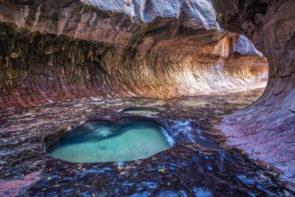
3. The Subway, Zion National Park
- Length: 9 or 9.5 miles
- Elevation gain: 1,300 ft for the bottom-up hike
- Difficulty: Strenuous
- Permit: Yes, for both bottom-up and top-down
The Subway is a day-use only area in Zion National Park that is characterized by long, tunnel-like rock passages that look like underground subways. There are two ways to hike the Subway and both are quite difficult and strenuous and require extensive route finding.
For a 9-mile bottom-up exploration of the Subway, you’ll do a round-trip hike through the Left Fork of North Creek. There is no ‘trail’, instead, you’ll be climbing over boulders and wading through creeks. I did this bottom-up route as a solo hike. You descend down into the canyon and then hike through the river up to the pools. Take a plunge if you want to brave the cold water, but be sure to save some energy for the climb out, especially on a hot sunny day.
The 9.5-mile top-down Subway route is an advanced canyoneering route that requires ropes, harnesses, rappelling skills, long swims through extremely cold water (wet suits are recommended), and route-finding skills.
How to get to the Subway
The Subway is located on Kolob Terrace Road, which can be accessed off of HWY 9 near the town of Virgin. The Zion shuttle does not pick up or drop off along this road, so you will need to drive your car or arrange a shuttle if you’re doing the top-down hike.
The bottom-up Subway hike starts at the Left Fork Trailhead while the top-down canyoneering Subway route begins at the Wildcat Canyon Trailhead and ends at the Left Fork Trailhead.
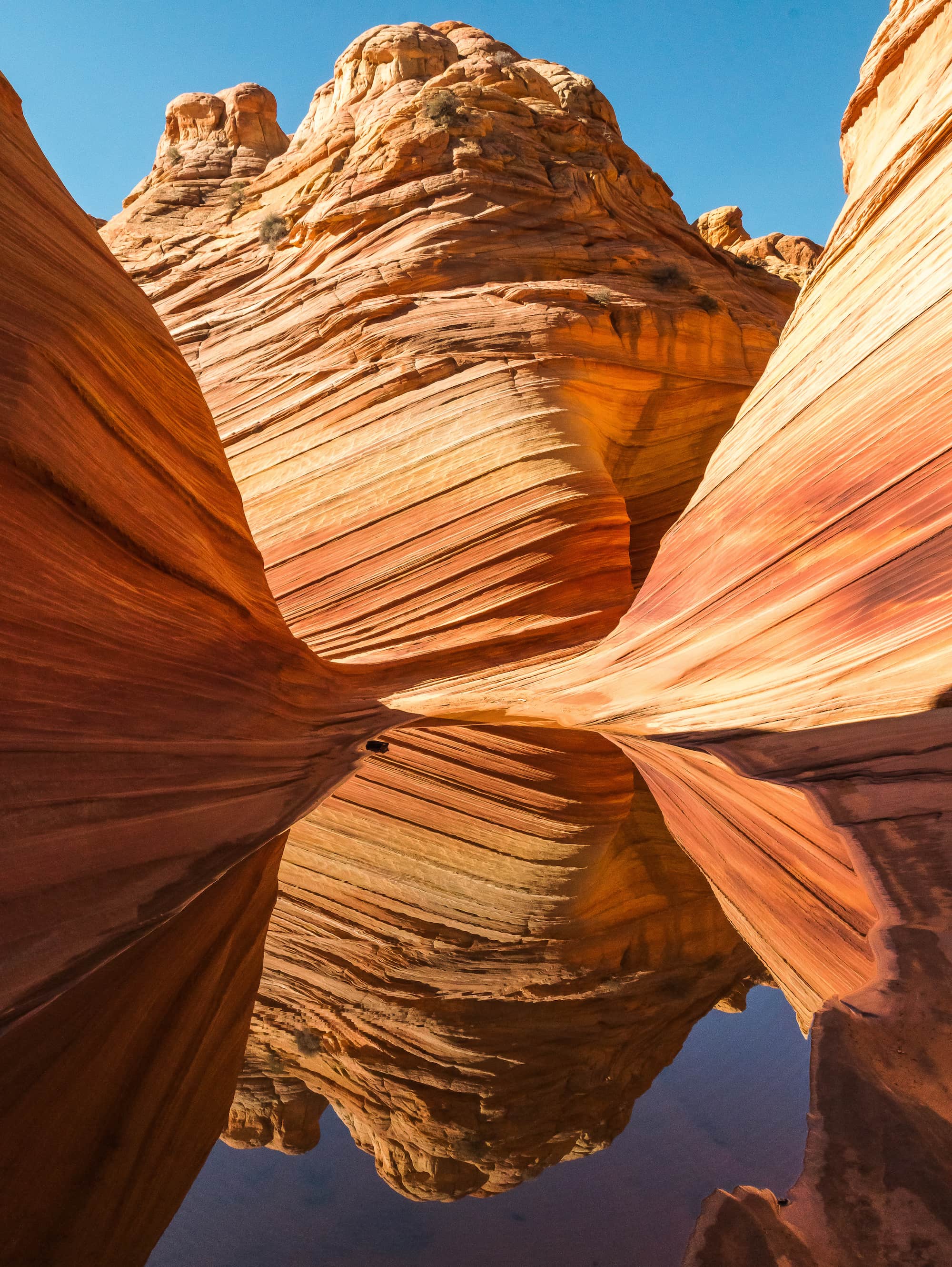
4. The Wave, Vermillion Cliffs Wilderness
- Length: 5.2 miles
- Elevation gain: 400 feet
- Difficulty: Moderate
- Permit: Yes
A mesmerizing trail of colorful red sandstone that crosses the Utah/Arizona border, the Wave is a popular and very sought-after hike with a highly competitive permit process (maybe one of the most competitive in the US).
While the odds might not be in your favor, those that are lucky enough to score one of the 64 daily permits (16 are walk-in) will find solitude while they are exploring the remarkable patterns and landscapes that make up the Wave.
How to get to the Wave
The closest town to the wave is Kanab. The Wire Pass trailhead, where you’ll start, is roughly a 1-hour drive from Kanab. The last 8 miles along House Rock Valley Road are on a dirt road that can be impassable due to flash floods that hit the region. Make sure to check conditions before heading out.
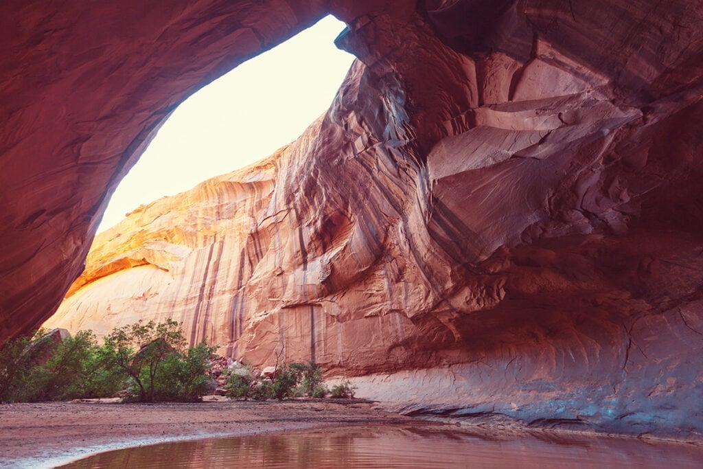
5. Golden Cathedral Trail, Grand Staircase-Escalante National Monument
- Length: 9.1 miles
- Elevation gain: 1,581 feet
- Difficulty: Moderate
- Permit: No
Located at the end of Neon Canyon in Grand Staircase-Escalante National Monument, Golden Cathedral is a beautiful, secluded hike in red rock country that leads you to an emerald pool grotto. In the cavernous ceiling, there is a hole that the sun rays beam through at a certain time of day, resulting in amazing lighting for photos.
The Golden Cathedral Trail is a longer hike that requires some navigation, so start early and bring a headlamp, food, water, and the 10 day-hiking essentials. I did this hike back in 2014 and didn’t see another person the entire day!
How to get to Golden Cathedral Trail
Drive 16.3 miles down Hole-in-the-Rock Road. Hole-in-the-Rock Road intersects with HWY 12. After driving 16.3 miles down Hole-in-the-Rock Road, take a left on Egypt Bench Road and drive another 9.9 miles down Egypt Bench Road to the trailhead. 4×4 and high clearance are needed.
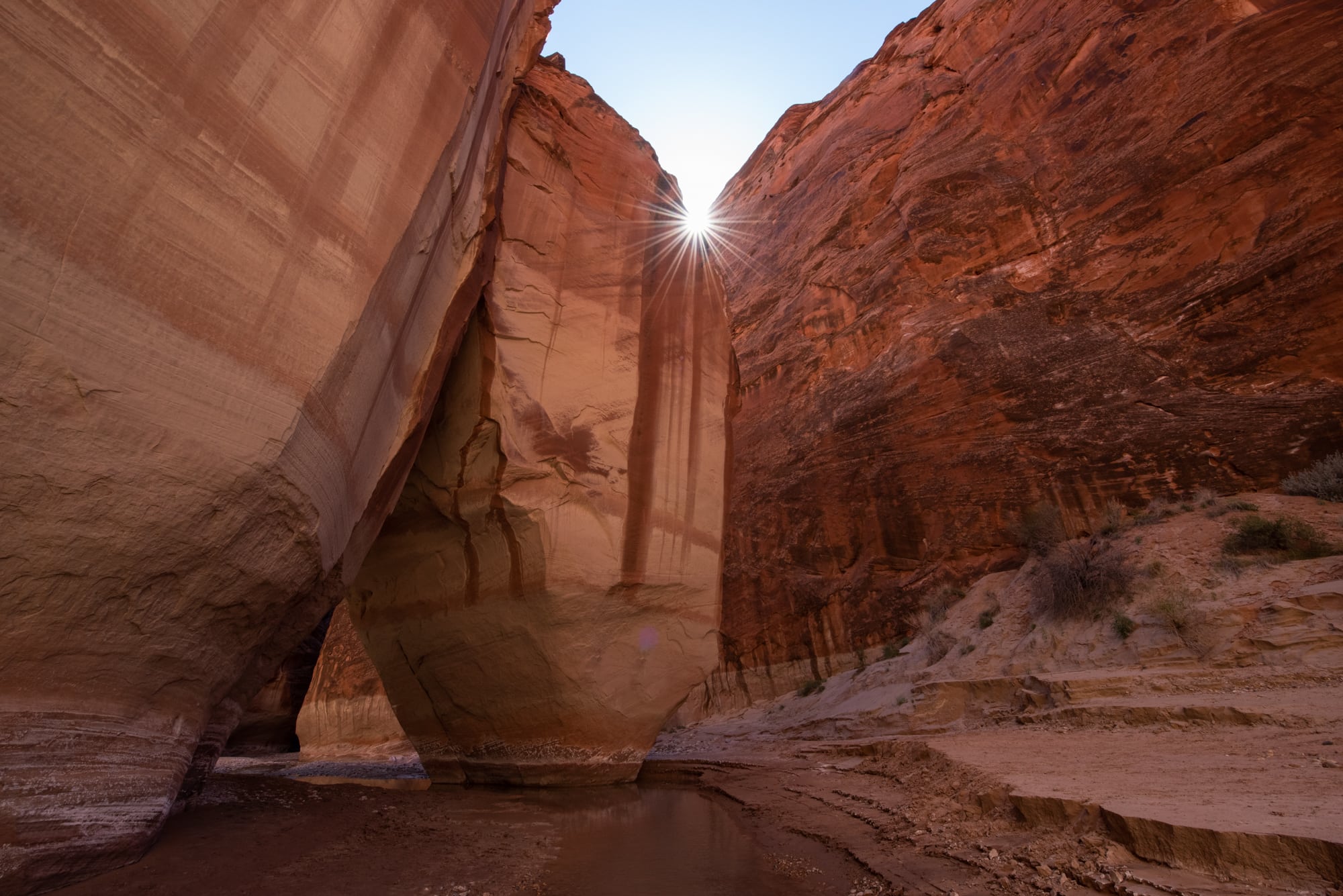
6. Paria Canyon Backpacking Trail, Vermillion Cliffs Wilderness
- Length: 38 miles
- Elevation gain: 1,130 feet decline
- Difficulty: Moderate
- Days: 4
- Permit: Yes
Paria Canyon is a 38 mile-long backpacking trek in and along the Paria riverbed between two enormous walls of Navajo sandstone. It’s similar to the Zion Narrows but is much more remote and isolated. Out of all of the backpacking I’ve done, this hike stands out as one of my all-time favorites.
The trip takes about 4 days and requires a car shuttle, but those that are able to deal with the challenging logistics will be rewarded with private riverside camping in one of Utah’s prettiest canyons. Get our full Paria Canyon backpacking guide with permit info here.
How to get to Paria Canyon
There are three different starting trailheads for Paria Canyon. The most popular, and the one that I started at, is via the White House Trailhead, which is two miles down the road from the BLM Paria Contact Station off of Highway 89 North.
Read next: Best Utah Backpacking Trips
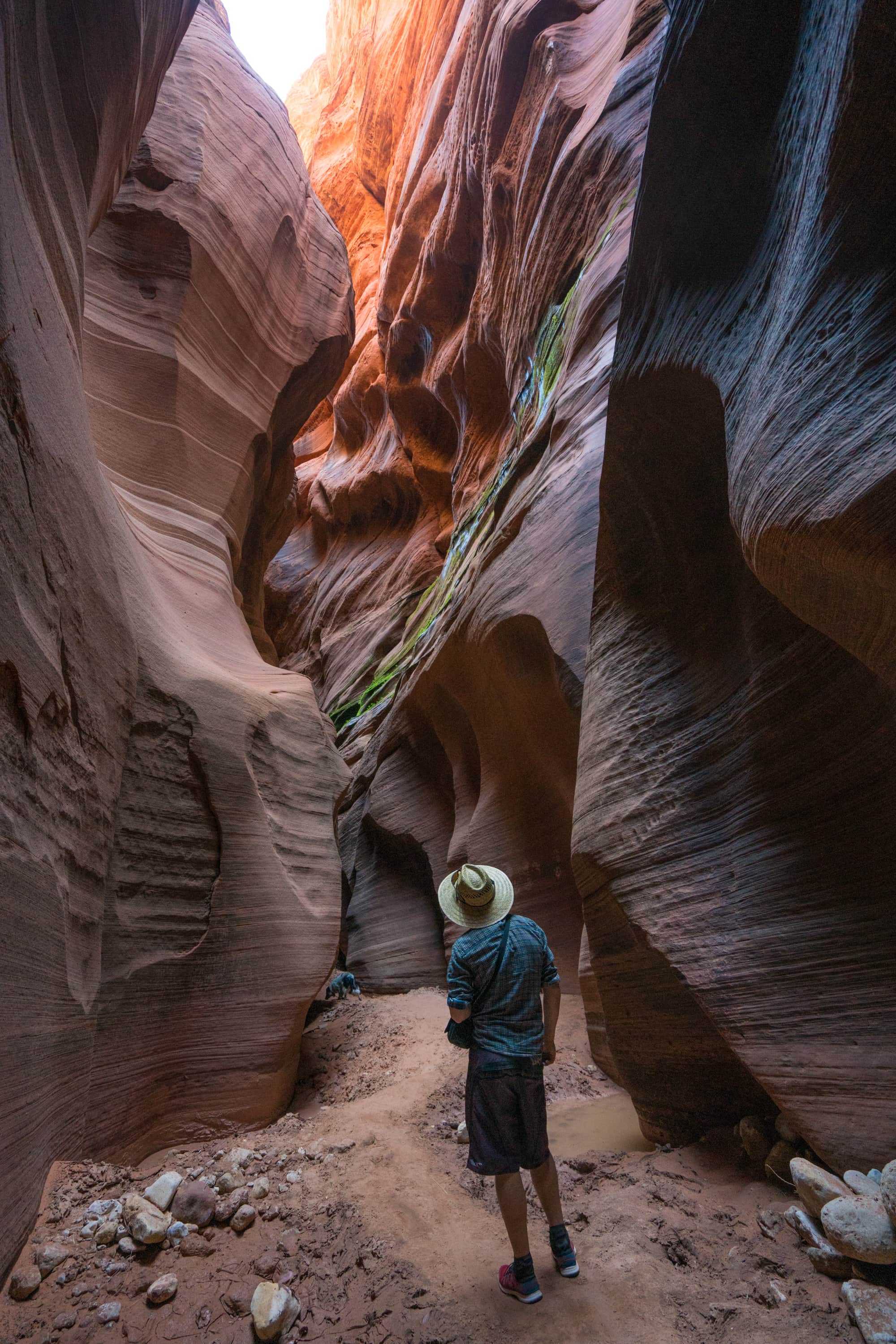
7. Buckskin Gulch Day Hike – Wire Pass Trailhead, Vermillion Cliffs Wilderness
- Length: up to 16 miles one way
- Elevation gain: 649 feet
- Difficulty: Strenuous
- Permit: Yes (Day-permits can be obtained via a self-pay station at the trailhead. Buckskin Gulch Overnight permits must be obtained in advance.)
Buckskin is the longest slot canyon in the world and many people only hike a section as an out-and-back trail. This specific route via Wire Pass has a short section that requires a downclimb over a boulder jam to access Buckskin. At the confluence of Wire Canyon and Buckskin Gulch, take some time to check out (with your eyes only) the ancient petroglyphs on the canyon walls.
Once you enter Buckskin, be prepared for cold water, boulder jams, and other obstacles, which can ultimately dictate your turn-around point. This hike is more enjoyable outside of winter months and the deepest pools will mostly be encountered during spring run-off.
If you plan on going deep into the canyon and wading through pools of water, proper shoes and neoprene socks for warmth are recommended.
Bring plenty of water or a water filter, as the water in the canyon is not safe to drink, and make sure there is no rain in the forecast. A flash flood in Buckskin would be deadly.
If you want to backpack Buckskin Gulch, the most common route is to enter via Wire Pass and exit at the Whitehouse Trailhead near the Paria Contact Station. For this a car shuttle and an advanced reservation permit are necessary.
How to get to Buckskin Gulch
The Buckskin Gulch Trailhead is easily accessible via House Rock Valley Road in Kanab, Utah. Walk across the street to the marked trail.
8. Lower Calf Creek Falls, Grand Staircase-Escalante National Monument
- Length: 6.7 miles
- Elevation gain: 512 feet
- Difficulty: Easy
- Permit: No
Lower Calf Creek Falls is one of the first hikes I ever did in Utah. It’s easy, flat, and dog-friendly and leads you to a giant waterfall in the middle of the Staircase-Escalante National Monument desert.
This hike is very popular due to quick access from the highway, so I’d recommend a mid-week sunrise or sunset hike to avoid the crowds.
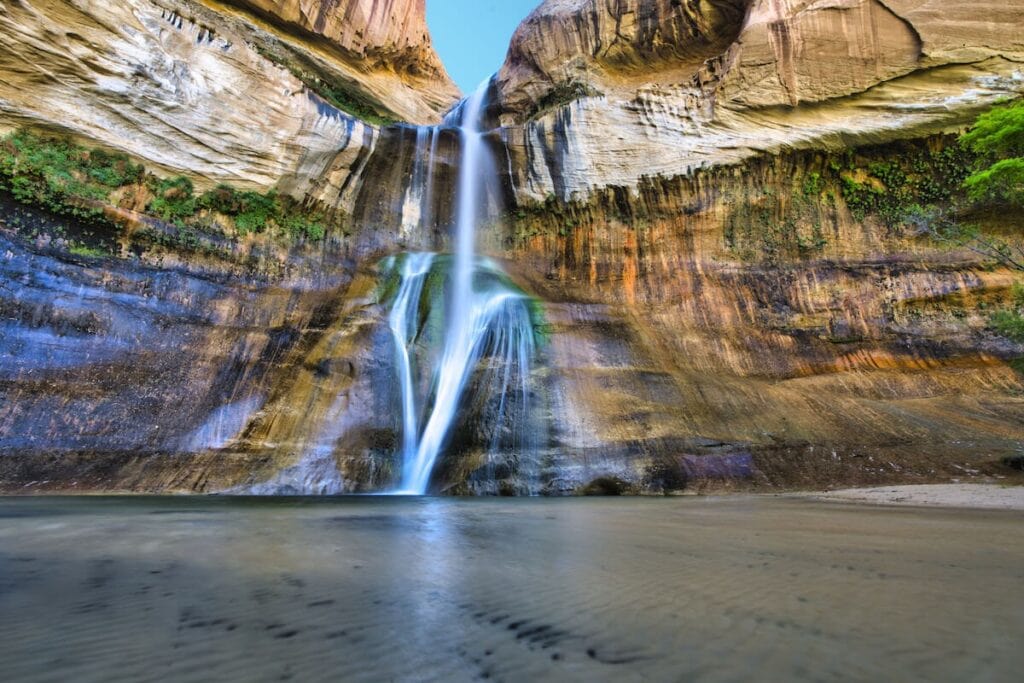
How to get to Calf Creek Falls
From the town of Escalante, take HWY 12 east until you see signs for Calf Creek Campground. The trail starts from the campground.
9. Coyote Gulch, Grand Staircase-Escalante National Monument
- Length: 13-22 miles depending on route
- Elevation gain: Varies
- Difficulty: Moderate
- Days: 1-3
- Permit: No permit needed for day hikes; permit needed for overnight backpacking trips
Coyote Gulch in Staircase-Escalante National Monument is similar to Paria Canyon in that it’s a gorgeous slot canyon in Utah’s red rock country, but it can be done in 1-3 days instead of 4 and it’s not as logistically challenging.
Coyote Gulch has been on my bucket list for a while, and I finally got to backpack through it with a friend a few years ago.
This is one of my favorite overnight backpacking hikes in Utah for beginners because it’s relatively flat and easy to navigate. You’ll pass towering canyon walls, a large mystic arch, a natural bridge, and numerous waterfalls along the route. Most of the trail is along stream beds, so expect your feet to be wet the whole time. For more information on planning your Coyote Gulch hike, read our Coyote Gulch Backpacking Guide.
Wag bags are required for this hike to pack out all human waste.
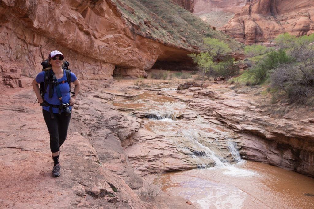
How to get to Coyote Gulch
All of the trailheads for Coyote Gulch are located off of Hole in the Rock Road, which is about 5 miles east of Escalante off of HWY 12.
There are a number of Coyote Gulch trailheads off of Hole in the Rock Road, so be sure to use the trail guides in our Coyote Gulch post for directions.
10. Delicate Arch Trail, Arches National Park
- Length: 3 miles
- Elevation gain: 610 feet
- Difficulty: Moderate
- Permit: No
Utah’s most famous arch (as displayed on the license plates!) is a scenic trail with panoramic views of Arches National Park and the La Sal Mountain range. Hiking out for sunset is a must-do, just bring a headlamp and a trail map on your phone to safely navigate back to your car once it’s dark.
If you have a few days to spend in the park, check out a few of our other favorite hikes in Arches National Park.
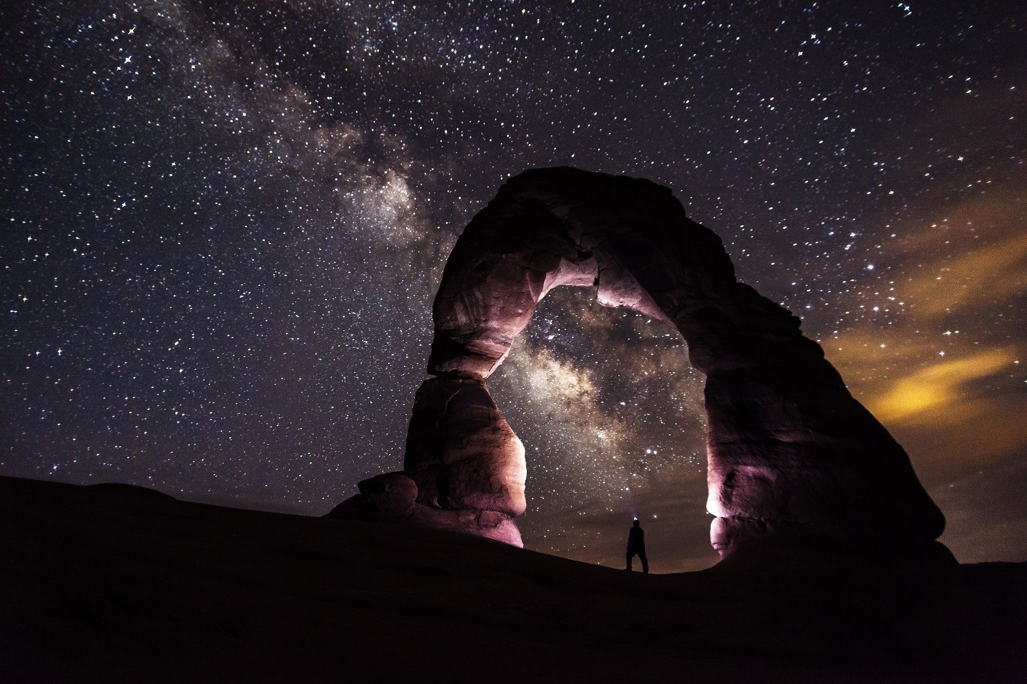
How to get to Delicate Arch
Within Arches National Park, drive a couple of miles down Wolfe Ranch Road to Wolfe Ranch for the trailhead.
11. Corona Arch, Arches National Park
- Length: 3 miles
- Elevation gain: 440 ft
- Difficulty: Easy
- Permit: No
Hiking out to Corona Arch, located just outside Arches National Park in Moab, is a great way to experience these delicate, sandstone wonders if you’re short on time or you’re traveling with a dog (this hike is pet-friendly!).
To get to the arch, it’s an easy 20-30 minute hike followed by a short scramble up a steep rock wall aided with safety cables. It sounds more difficult than it is! After that, you’ll be rewarded with amazing views of the Corona Arch and surrounding mesas. For more detailed directions and information, head over to our Corona Arch Trail Guide.
If you’re feeling motivated, this is also a great place to practice night photography if you’re willing to hike out there by headlamp.
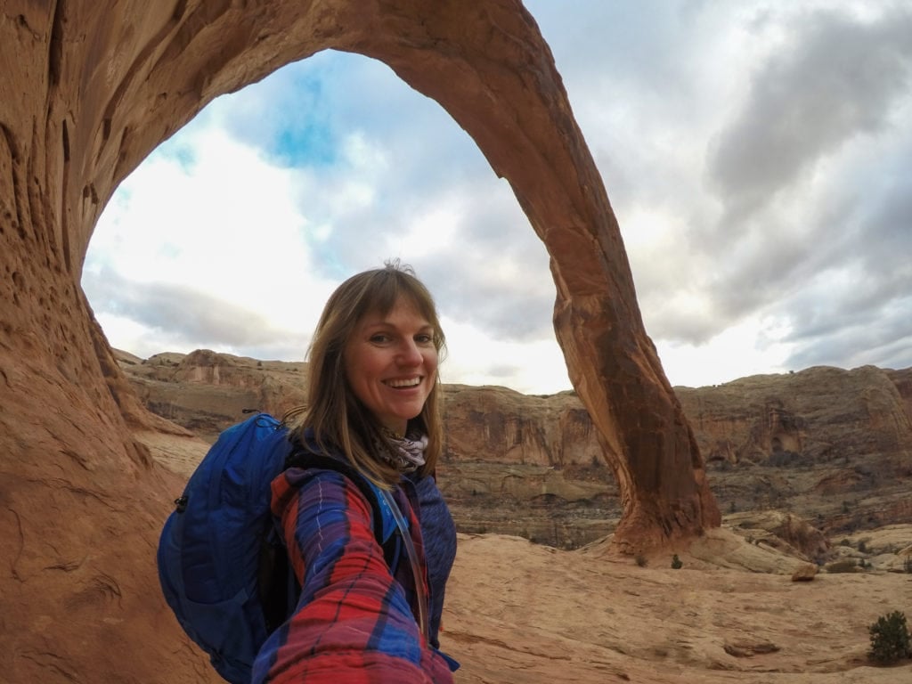
How to get to Corona Arch
Corona Arch is located in Bootleg Canyon, about 20 minutes outside of Moab. Head 4 miles North on HWY 191 towards Potash Road (State Road 279). Turn left on Potash Road and head west for 10 miles down Potash Road to the trailhead which is well signed as “Corona Arch Trailhead”. Turn right into the Corona Arch parking lot and a kiosk with information.
12. Mount Timpanogos, Wasatch Mountain Range
- Length: 14 miles
- Elevation gain: 4,390 feet
- Difficulty: Strenuous
- Permit: No, trailhead fee per car
Peaking at 11,752 feet, Mount Timpanogos is the second-highest peak in Salt Lake City’s Wasatch Range and is known for its vibrant wildflowers, resident mountain goats, and sweeping views.
The Timpooneke Trail to the top of Mount Timpanogos is a tough, but not technical, hike that is totally worth the climb. It can be done as a long strenuous day hike or an overnight backpacking trip. Get more info in our Mount Timpanogos Trail Guide.
How to get to Mount Timpanogos
There are two different ways to access the Timpooneke trailhead: from I-15, take the Orem 800 North Exit 272. Travel east on 800 North, Highway 52, to the mouth of Provo Canyon. Take a left turn onto Highway 189, Provo Canyon Scenic Byway. Then left onto Highway 92, Alpine Scenic Loop/Sundance turnoff to the North Fork of Provo Canyon. This section of the road is narrow and winding which requires caution.
Or from I-15, you can take the American Fork/Alpine Exit 284 and turn east onto Highway 92. This takes you through American Fork Canyon. Continue on this road, making a right turn onto the south fork.
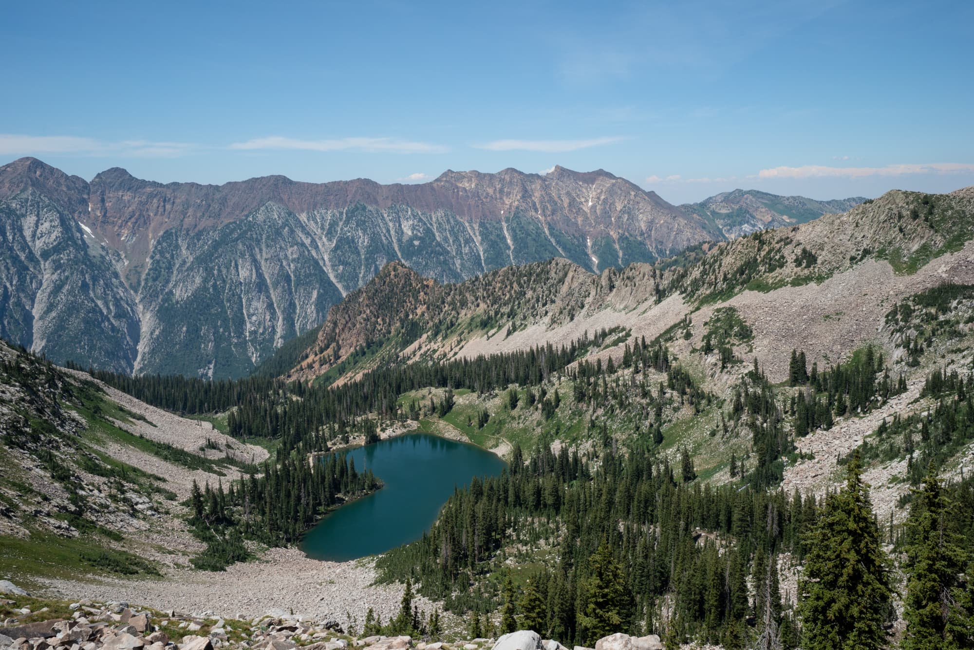
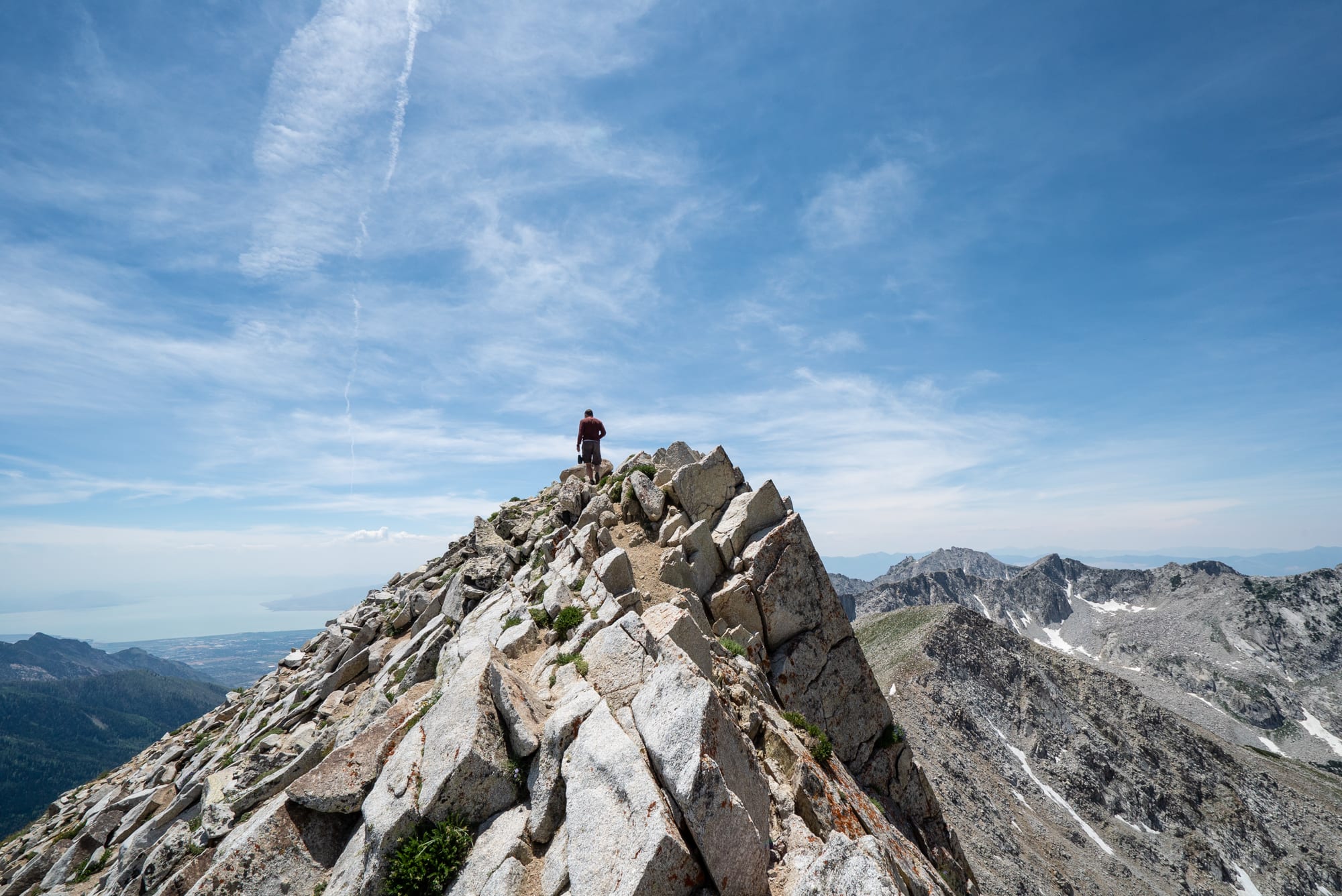
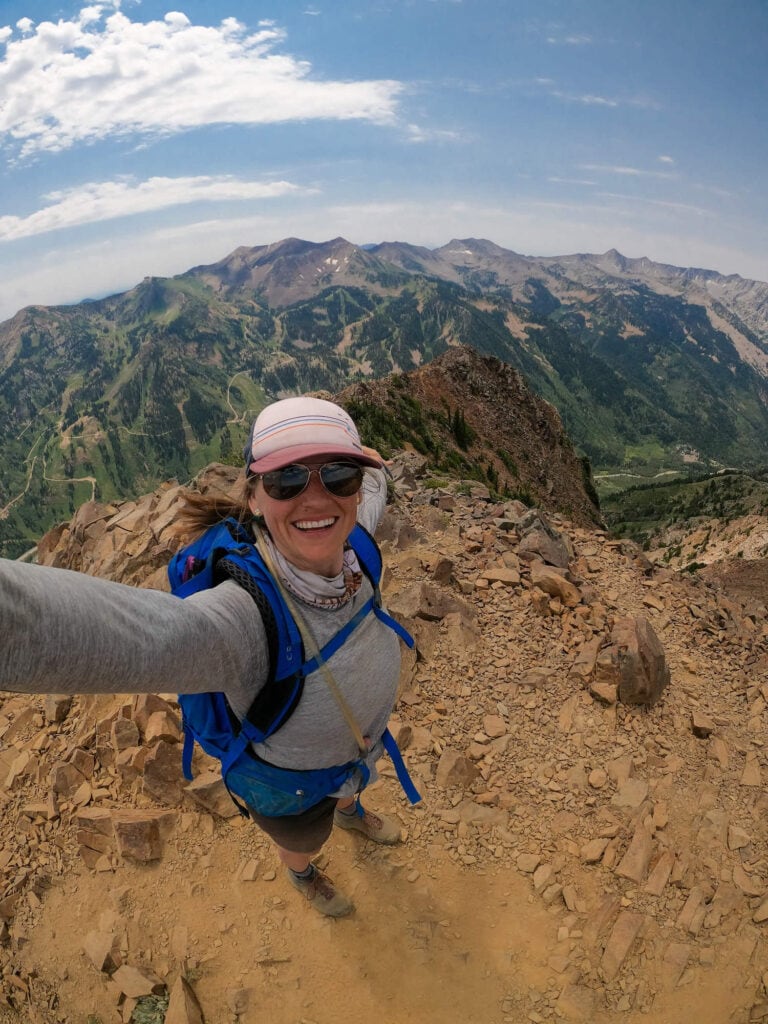
13. Pfiefferhorn Trail, Wasatch Mountain Range
- Length: 9 miles
- Elevation gain: 3,800 feet
- Difficulty: Strenuous
- Permit: No
Pfiefferhorn is the third tallest peak in Utah’s Wasatch Range at 11,326 feet high and is one of the best hikes in Utah to do while you’re in Salt Lake City. Along the way, you’ll pass Red Pine Lake, a gorgeous and popular hiking destination in the Wasatch.
Past the lake, the trail up to the Pfiefferhorn requires some scrambling, navigating a knife ridgeline, and hiking a steep section to reach the summit. It’s a hike that will get your blood pumping but doesn’t actually require any technical climbing gear. Get more details in my Pfeifferhorn Trail Guide.
How to get to Pfiefferhorn Trail
From Salt Lake City, take I-80 and merge onto I-215 S. Continue on I-215 S for 5 miles and take exit 6 onto 6200 S. Go left at the light and take 6200 S following signs to Alta Ski Area. After 4 miles, this road curves left up Little Cottonwood Canyon becoming Little Cottonwood Canyon road. Continue driving up the canyon for 5.5 miles. Keep an eye out for signs on the right for the White Pine Lake Trailhead and turn right into the large paved parking lot. If you get to Snowbird Ski Resort, you’ve gone too far.
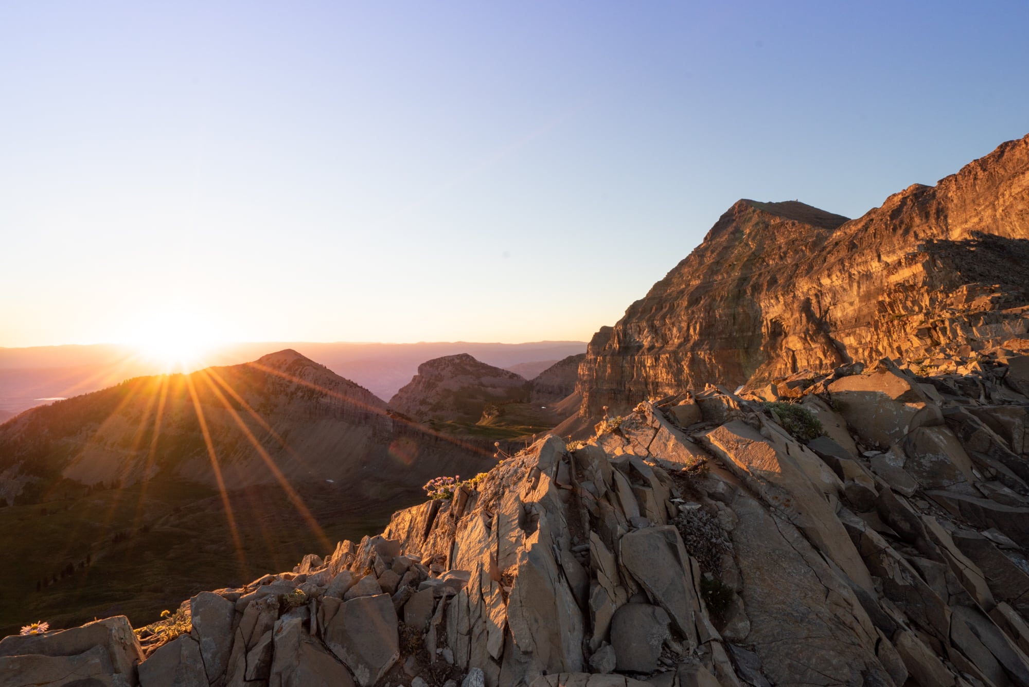
14. Monte Cristo via Cardiff Pass Trail, Wasatch Mountain Range
- Length: 5.3 miles
- Elevation gain: 2,477 feet
- Difficulty: Strenuous
- Permit: No
The Monte Cristo via Cardiff Pass Trail rewards hikers with amazing views of the Wasatch range and surrounding ski areas. The trail leaves from Alta Ski Area to the east of Salt Lake City and makes its way up to the summits of both Monte Cristo and Mt. Superior.
Do not underestimate this hike. It’s a very steep climb with some dicey sections of scrambling, making it suitable only for advanced hikers comfortable with exposure. When I did this hike, there were a few points where I got nervous, but I stayed focused and took my time – standing on the top was well worth the effort!
I highly recommend taking a pair of trekking poles that collapse so that you can put them in your bag when need to use your hands for scrambling and balance. There’s also no shade on the trail, so be sure you’re prepared with plenty of sun protection.
How to get to Monte Cristo via Cardiff Pass Trail
Drive east along HWY 210 toward Alta Ski Area. Take a left onto Michigan City Road and the Cardiff Pass Trailhead will be on your left.
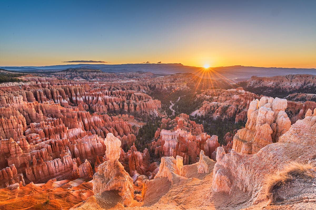
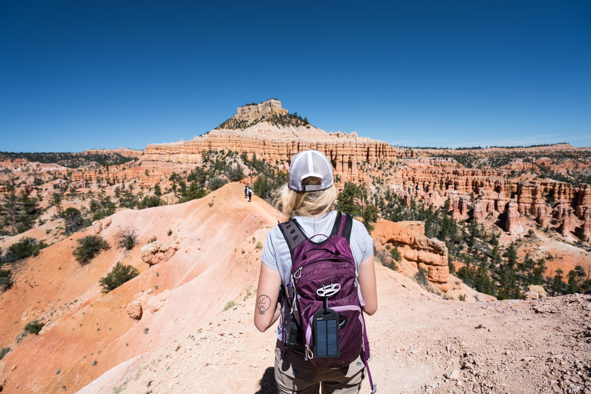
15. Fairyland Loop, Bryce Canyon
- Length: 7.4 miles
- Elevation gain: 1,514 feet
- Difficulty: Strenuous
- Permit: No
The Fairyland Loop trail is a spectacular hike through Bryce Canyon National Park’s northern region. Walk past the spiraling hoodoos that make the park famous and trek all the way from the rim until you eventually get down into the canyon itself.
You’ll experience a lot of the same landscapes as the popular Navajo Loop Trail with a lot less foot traffic. This hike is considered challenging because it takes you up through different elevations, and you can have long exposure to the sun.
Looking to spend more time in Bryce Canyon? Plan your trip to Bryce Canyon with my guides:
How to get to Fairyland Loop
From the Bryce Canyon Visitor Center, drive one mile down Scenic Drive to get to the access road for Fairyland Point. Make a right and drive another mile to the parking lot.
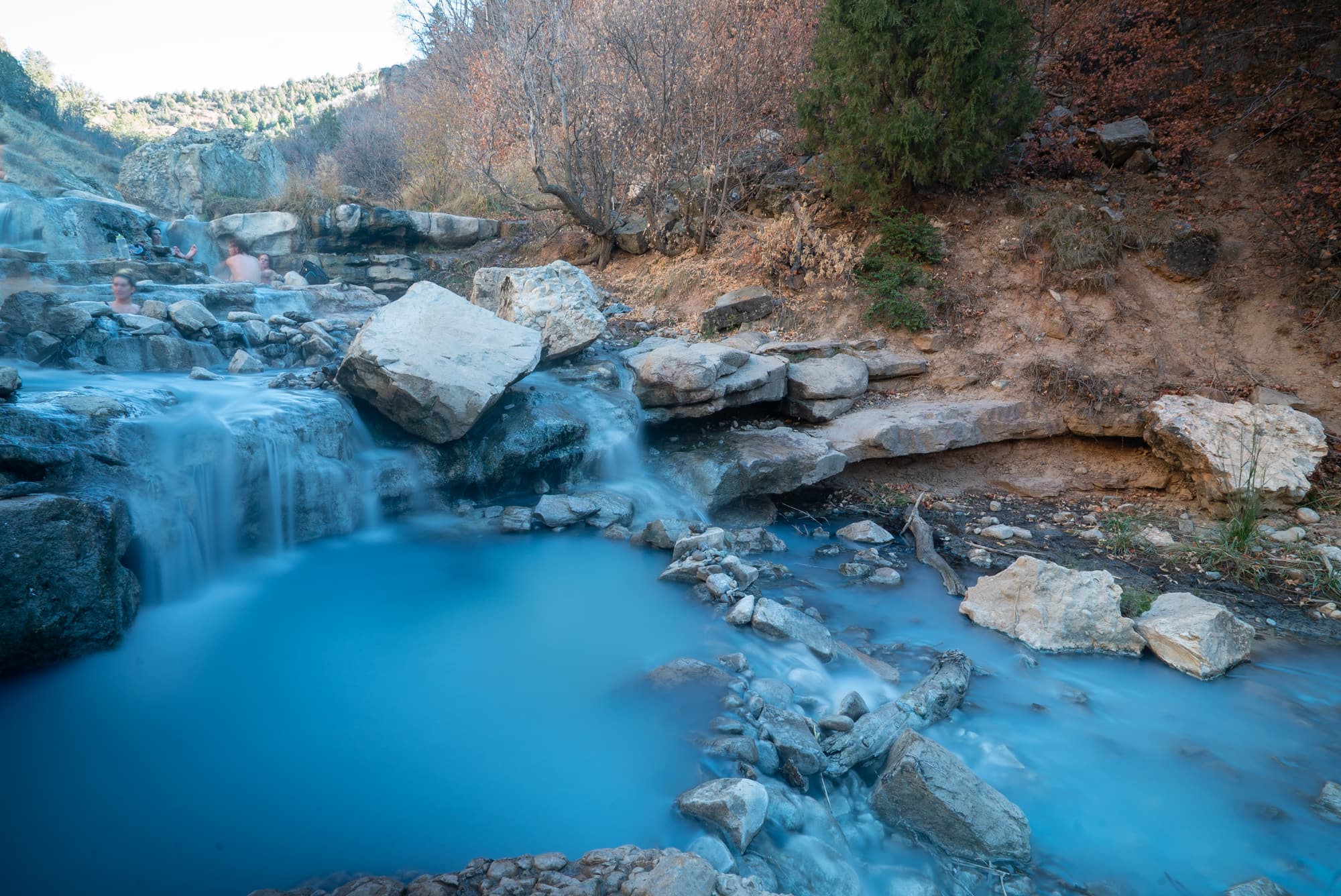
16. Diamond Fork Hot Springs Trail, Springville
- Length: 4.5 miles round trip
- Elevation gain: 700 feet
- Difficulty: Easy
- Permit: No
A hike to the Diamond Fork Hot Springs is a must-do and one of the best hikes in Utah because of its blue hot spring lagoons and beautiful scenery. The hike itself, along the river, is quite enjoyable and you’ll know you’ve arrived when the smell of sulfur fills the air.
Sit and soak in the naturally heated pools (I found the temperature to be perfect!), surrounded by stunning canyon walls and take it all in. Bring a towel, water and a change of clothes. If visiting in winter, check the road status before you head out. For more information check out our complete trail guide to Utah’s Diamond Fork Hot Springs.
How to get to Diamond Forks Hot Springs Trail
From Salt Lake City, head south on 1-15 until you reach the town of Spanish Fork. Once in Spanish Fork, take exit 257 to get on the US-6E. Drive for 11 miles, and take a left at mile marker 184 onto Diamond Fork Road. Follow this road for 10 miles until you reach the signed trailhead parking lot on the right.
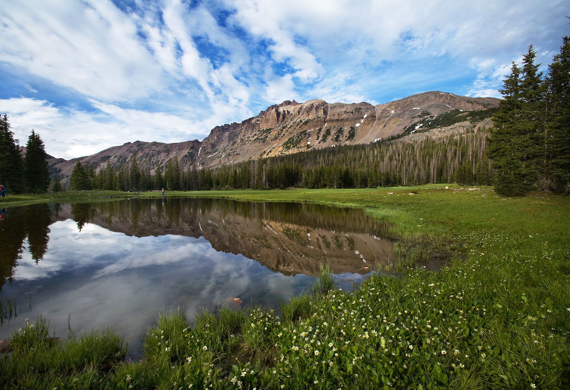
17. The Highline Trail, Uinta Mountains
- Length: 78 miles
- Elevation gain: 2,754 feet (trail stays mainly above 10,000 feet high)
- Difficulty: Strenuous
- Days: 7-8
- Permit: No
An easy contender on my list of best hikes in Utah is the Highline Trail, one that I have yet to cross off my bucket list. This multi-day trip is not for the faint of heart. For almost the entire hike, you’ll be above the timberline at 10,000 feet high and at times, this trail requires technical skills.
Plan ahead, be prepared, and do a little training ahead of time to really get in shape for this incredible hike.
How to get to the Highline Trail
The Highline trailhead is located right off of Mirror Lake Highway (U-150). The closest town is Kamas, Utah.
18. Little Wild Horse/Bell Canyon Trail, Hanksville
- Length: 11.2 miles
- Elevation gain: 1,617 feet
- Difficulty: Moderate
- Permit: No
One of Utah’s most spectacular, non-technical slot canyons is Little Wild Horse/Bell Canyon. It’s a loop trail with amazing views. Little Wild Horse/Bell Canyon is good for hikers of most skill levels and doesn’t require any technical gear or sketchy climbing.
Most people hike up Little Wild Horse, hang a left on the Behind the Reef connector trail, and then hike back down Bell Canyon. It’s a full day if you end up hiking the full loop. If you don’t have time, I suggest hiking up Little Wild Horse as far as you like and then back down the same way.
Like all of the slot canyon hikes here, keep an eye on the weather and if rain is in the forecast, save this trail for next time.
How to get to Little Wild Horse Trailhead
To find the trailhead and parking area, drive 11 miles down Highway 24, about 2 miles before the Goblin Valley State Park Fee Station. Look for the sign to see where to turn off.
Read next: Goblin Valley is also home to more great hiking and things to see and do. Use our Goblin Valley travel guide to help plan your trip!
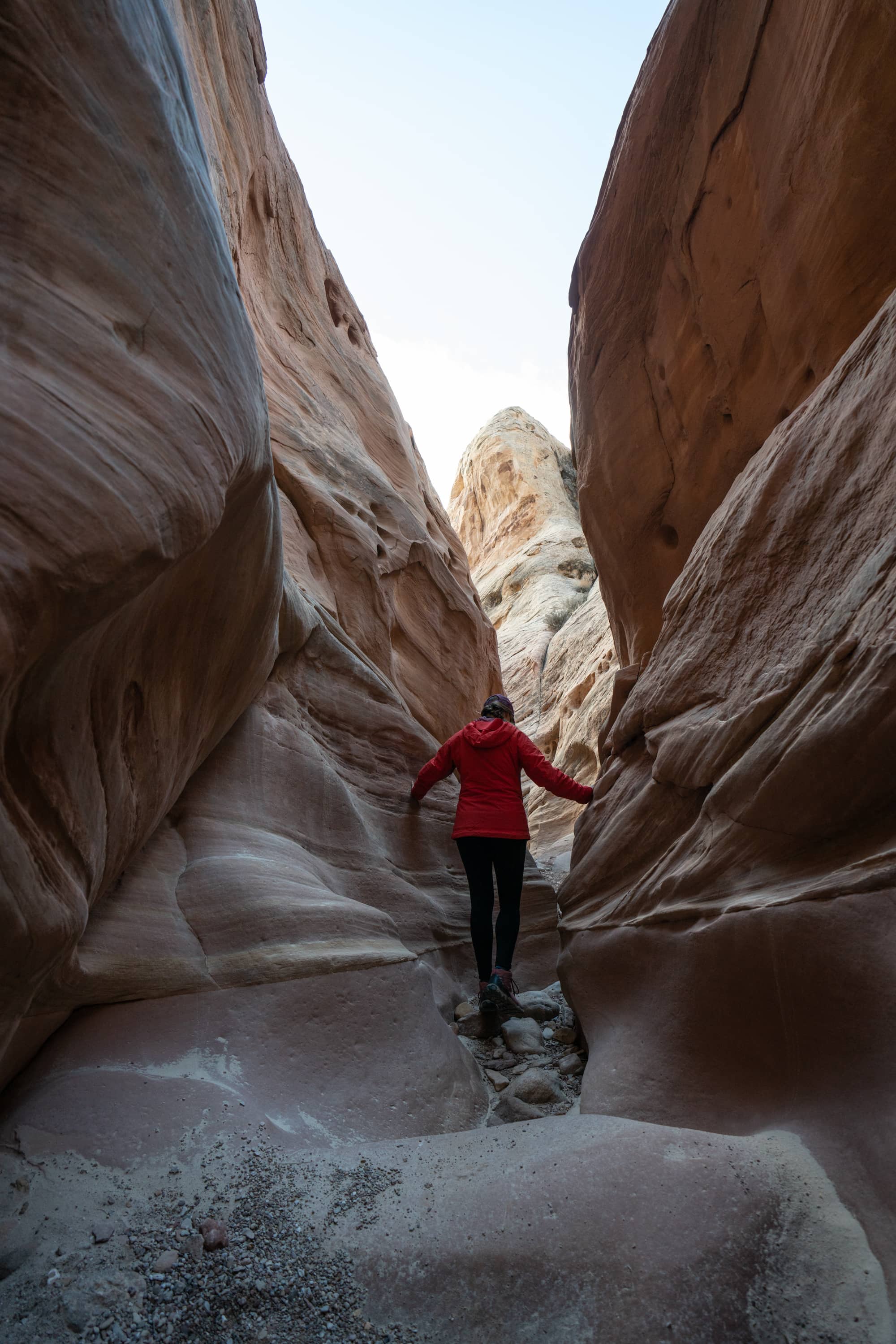
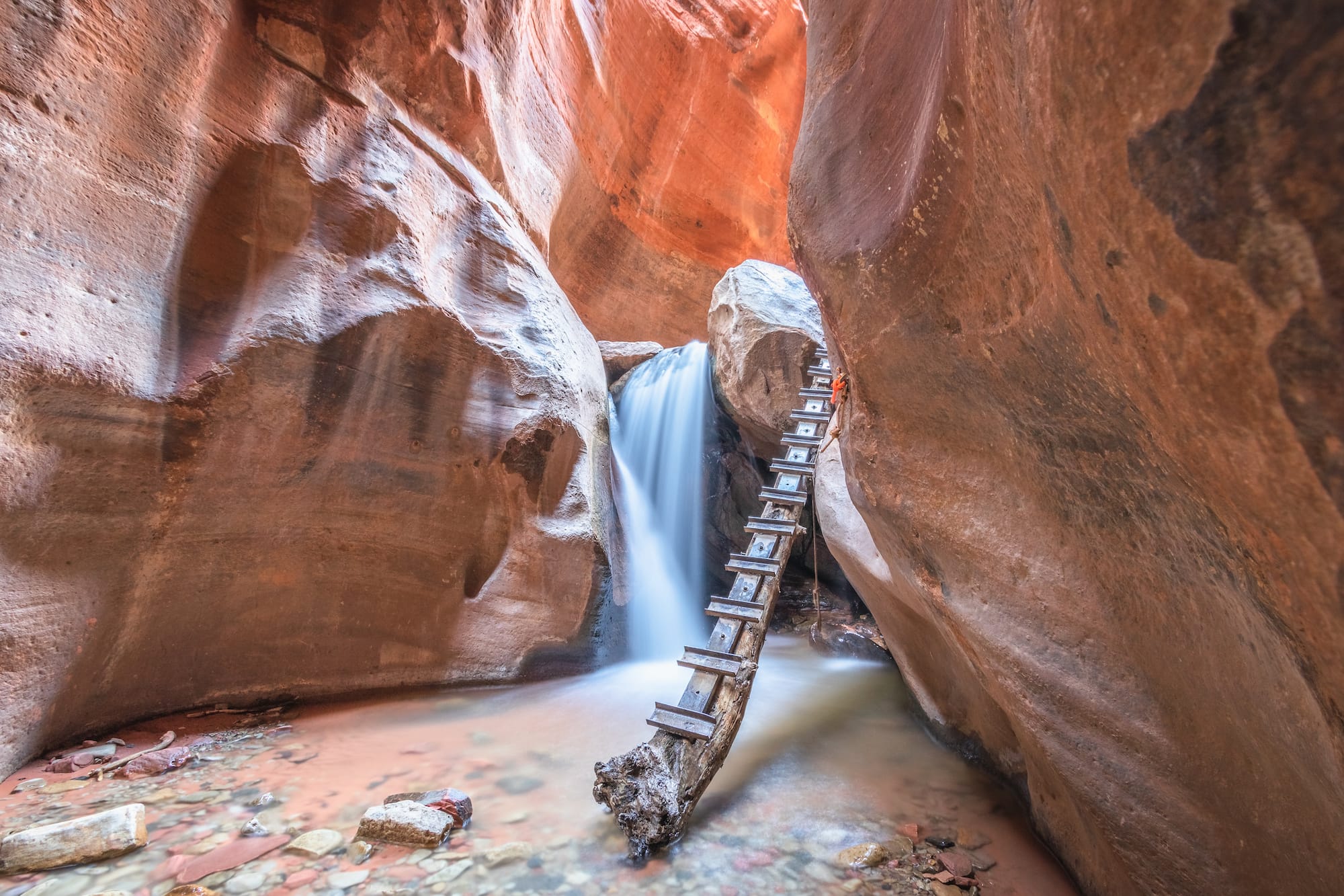
19. Kannara Creek Canyon Trail, Kannaraville
- Length: 2.7 miles
- Elevation gain: 456 feet
- Difficulty: Moderate
- Permit: Yes; $12 permit that you can obtain here
This trail brings you the best of Utah landscapes: Slot canyons, not one but two waterfalls, views, and that orange canyon glow. Kannara Creek Canyon Trail also features a few handbuilt ladders to climb further down into the canyon.
I recommended you wear water shoes you can hike in – like these Astrals, which are my favorite for hiking in desert streams. Also, I did this hike in November, and the water was freezing! I had neoprene socks which were extremely helpful in preventing my feet from getting too cold.
As always, when hiking in slot canyons, check the weather conditions to avoid flash floods. Kannara Creek has gotten very popular over the years, so make sure to check the website for the latest info on permits and daily limits.
How to get to Kannara Creek Canyon Trail
From the Kannara Falls parking lot, start walking up the trail by the information sign. Alternatively, from the Sweet Spot parking lot follow the road east for a couple hundred feet to the Permit Kiosk. Here the attendant will scan your permit and let you proceed on the hike.
20. Frary Peak Trail on Antelope Island
- Length: 6.9 miles
- Elevation gain: 2,335 ft
- Difficulty: Strenuous
- Permit: No, but entry fee to the state park
Located on Antelope Island outside of Salt Lake City, this out-and-back hike takes you up to the top of Frary Peak, the highest point on the island, for great views of the Great Salt Lakes. The trail can get snowy and muddy in winter, so it’s best left for late spring (when nearby mountains are still snowcapped) and fall. Summertime also gets very hot, so early morning hikes are best to avoid both the heat and crowds.
When I hiked this in May, I also got glimpses of the bison that live on the island. If you’re lucky enough to see them, be sure to keep your distance and give them plenty of space.
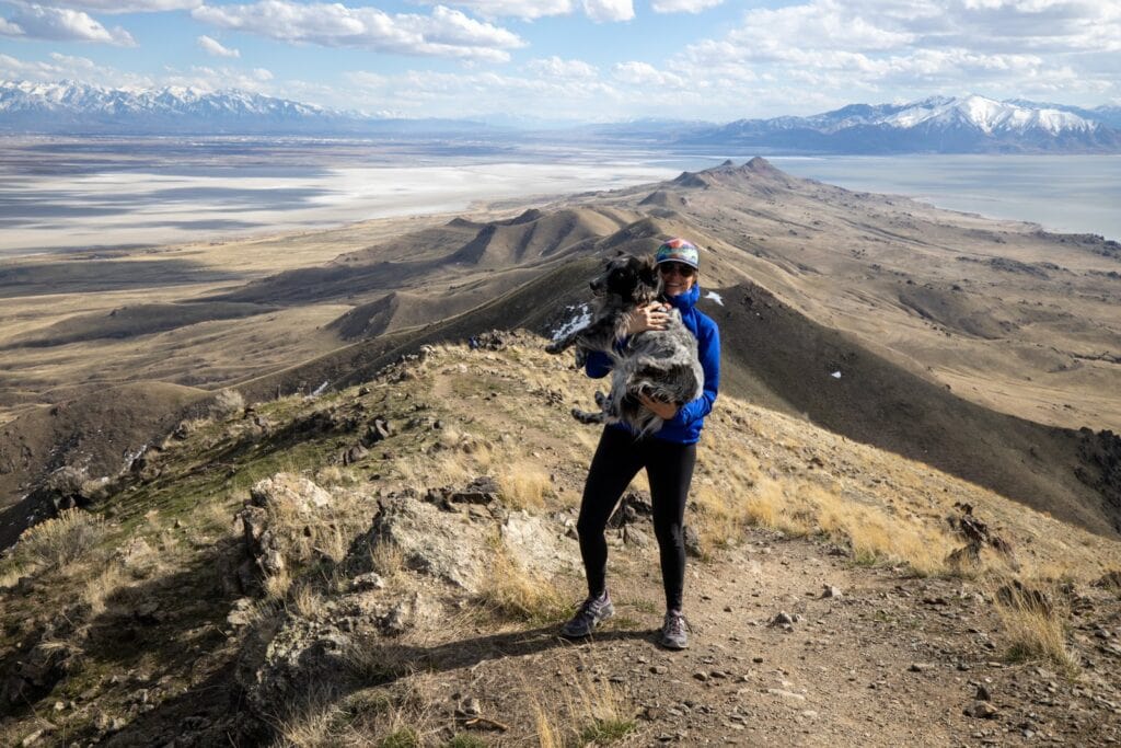
How to get to Frary Peak Trail
The bridge onto Antelope Island can be accessed via HWY 127. There is a $15 state park day-use fee that can be paid at the entrance or online. From the entrance, follow Antelope Island Road onto the island and stay left at the fork. Continue on until you see Frary Peak Trailhead Road on the right.
My Favorite Utah Hiking Resources
With cell service being limited in parts of Utah, it’s not a bad idea to invest in a hiking book or map for your trip. Here are the Utah hiking resources I’ve found to be most helpful over the years:
- Hiking from Here to WOW: Utah Canyon Country – this is hands-down the best book for finding Southern Utah hiking trails. It covers all of the Mighty 5 National Parks and more.
- Utah National Parks National Geographic Map Pack – this bundle includes Nat Geo topo maps for all 5 of Utah’s National Parks. These maps will give you the lay of the land, show you where the Park campgrounds are located and feature all of the major hiking trails in the Parks.
- Utah Benchmark Road and Recreation Atlas – if you want to get off the beaten path and explore Utah’s dirt roads, this is a great atlas to have on your road trip.
- 60 Hikes Within 60 Miles: Salt Lake City – consider this your trail guide for the best hikes around Salt Lake City
Which of these hikes in Utah would you like to explore? Which ones have you already hiked? Leave us a comment below!
This is an awesome list, thanks for sharing it! We’ve done Angels Landing, The Narrows, and a different hike within Bryce Canyon NP and loved them all. But there is so much that we hadn’t even considered for Utah, and I’m definitely adding a few of these to our “must-do” list.
Adding some of these to our list! Also, an update – we were at Kanarra Falls about 2 weeks ago and the permit cost per person was $12. Thanks for this great compilation!
Thank you so much! We’re planning a trip in the Fall and his will help tremendously!!
I love your site and the interactive map. My son and I will be in SLC this Friday and taking our rental to Denver. Any hikes you’d recommend for a short stay of only 2 days? I was thinking Moab because of its proximity to Denver? Any suggestions would be greatly appreciated. Any closures due to Covid?
Hi Robyn, thanks for reading! We just published a Colorado Road Trip blog post that you might find helpful for your trip: https://bearfoottheory.com/colorado-road-trip-stops/. You’ll want to check local websites for updates on closures and guidelines due to COVID. Visitutah.com and colorado.com are good places to start. Safe travels!
The Diamond Fork Hot Springs has been closed since spring 2020 due to public health concerns and Covid. 🙁 The gate at the trailhead parking lot is closed. I’ve heard some folks are still hiking it from further out (like in winter), but I’ve also heard it’s a hefty fine if caught.
https://www.fs.usda.gov/recarea/uwcnf/recarea/?recid=9861
Thanks for the tip, Alex. We’ve updated the post
Outstanding article !
Thanks for reading, Alex!
Leave No Trace can also include enjoying these beautiful places privately without indulging your own sense of importance by posting your opinion on social media
People are going to find these places whether we post about them or not. By emphasizing Leave No Trace on all of my blog posts, it educates and encourages everyone to be better stewards of the outdoors.
One of my favorites is Upper Muley Twist in Capitol Reef.
Thanks for the suggestion, Joan! We’ll have to check it out sometime.
Have you hiked Ding and Dang Slot Canyon next to Little Wild Horse? I’ve heard it’s even better!
No we haven’t, we’ll have to check that out! Thanks for the tip.
I’m sure Ding and Dang are great! But, I did hear just a couple of days ago that it requires descending on ropes and wading in waste deep water. It might dry up at certain times of the year but currently it’s full of water. Just fyi!
Excellent list! Thanks for putting it all together in a succinct article. I was running out of ideas for my Utah road trip. Thank you!! ~Kate
Glad you found it helpful – have a great trip!