Best Section Hikes on the John Muir Trail
Here are the best section hikes on the John Muir Trail that require less than a week to complete.

Taking 3 weeks off to hike the John Muir Trail isn’t always feasible. Not to mention you also have to score a JMT permit with a date that works for you, which is becoming more competitive every year. If you aren’t able to hike the entire JMT, why not section hike a portion of the trail?
One of the biggest advantages of doing a section hike on the John Muir Trail vs. a thru-hike is that you also don’t need to worry about the infamous JMT resupply hassles.
In this blog post, we’ve put together a list of our favorite John Muir Trail section hikes that offer up the best views and terrain of the High Sierra to get you out the door and exploring. These incredible backpacking trips are also great options for visiting Pacific Crest Trail or JMT thru-hiking friends during their trek.
This blog post was originally written by BFT Founder, Kristen, who hiked the John Muir Trail Southbound in 2014. It was updated in 2023 by Mary Caperton Morton of The Blonde Coyote who hiked the John Muir Trail Northbound in 2020. It includes the most recently available information.
This post may contain affiliate links.
Tips For Preparing For Your John Muir Trail Section Hike
Before heading out on your JMT section hike, there are a few important planning details to consider:
Transportation Options Between Trailheads
You’ll need to plan for transportation before hiking any of the John Muir Trail section hikes. Where public transit is available, we list those options below. Otherwise, you’ll need to plan on having two cars or hitchhiking to and from trailheads.
There are also numerous private shuttle companies that offer one-way and roundtrip transportation to trailheads all over the Eastern Sierra Nevada mountains. Depending on your start and endpoint, you might find some applicable info in our JMT Transportation Planning Guide.
Don’t Forget Your Bear Canister
A bear canister is required for the entire length of the JMT, even if you’re just doing a section hike. You can rent one at the Yosemite Wilderness permit office for (no reservation needed) or purchase one. You can check out our favorite bear canisters here.
Read next: Need gear recommendations? Check out our 3-Day Backpacking Checklist
Save this post!
Enter your email & I'll send this post to your inbox! You'll also receive my weekly newsletter full of helpful advice for planning your adventures.
John Muir Trail Section Hike Permits
You will need a permit for all section hikes on the John Muir Trail. Not a full-blown JMT thru-hiking permit, but still – a permit. For the 2023 season, all permits are being issued through Recreation.gov, including walk-up permits, which are released online 2 weeks before the start date.
Limited walk-up permits are available in person at some Ranger Stations for certain trailheads– but always call ahead to confirm. Usually, only a handful of walk-up permits are available each day, but you may get lucky with last-minute cancellations. More information on wilderness permits for overnight trips in Inyo National Forest and the John Muir Wilderness areas can be found on the Recreation.gov website.
Wilderness permits are required year-round for overnight trips in the Ansel Adams, John Muir, Hoover, and Golden Trout Wilderness areas, as well as in Yosemite, Kings Canyon, and Sequoia National Parks, and Inyo National Forest.
During the off-season, usually from September 15 to April 30, there is no cap on the number of permits issued. During the busy summer months, the number of permits issued for each trailhead each day is restricted to a certain number to keep trails from being too crowded.
Your permit is issued based on your starting trailhead. If you start a JMT section hike in Yosemite, a Yosemite permit will cover you in all the other wilderness zones along your route.
In general, permits are harder to get in National Parks, and easier in wilderness areas and National Forests. Permits are released on Recreation.gov 24 weeks ahead of the start date. So if you want to start your hike on July 1st, you’ll want to log on to Recreation.gov on January 1st at 7am, Pacific time to secure a permit.
On all National Forest sections of the JMT, campfire permits are also required for campfires, stoves, and lanterns. You can quickly and easily get a California campfire permit online. Note that campfires are restricted in some areas, including the alpine zone.
6 Best John Muir Trail Section Hikes
Ranging from 28 miles to 65 miles, these section hikes will give you a taste of all you can experience on the John Muir Trail and the High Sierra of California. Most JMT hikers start in Yosemite Valley and head south, ending at Mt. Whitney, so we have listed all of these hikes in a similar fashion. Keep in mind any of these hikes can be reversed as well.
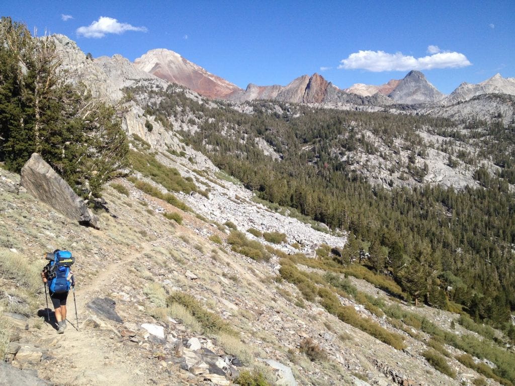
1. Yosemite Valley to Tuolumne Meadows (~20 miles)
- Starting Point: Happy Isles Trailhead in Yosemite Valley
- Ending Point: Cathedral Lake Trailhead in Tuolumne Meadows, Yosemite National Park
- JMT Miles: Mile 0 to Mile 20.8
An iconic section hike through Yosemite National Park, this route generally takes 2-3 nights depending on your pace. Cathedral Lakes is a must-see in Yosemite and offered one of my favorite campsites in all of the JMT. This section also passes by some of Yosemite’s most iconic waterfalls as long as it’s early enough in the season that water is still running.
Yosemite offers a convenient shuttle system throughout the park and between the two trailheads making planning with just one car and a one-way route a cinch. Be sure to check the official Yosemite National Park website for updated information as you start planning. You can also summit Half Dome from this route (an additional permit is required for Half Dome).
Transportation Options Between Trailheads
Between June 15th and October 15th, you can take the YARTS bus shuttle to and from your start location which makes completing this section hike on the John Muir Trail easy with just one car. We recommend parking your car at the Tuolumne Meadows Visitor Center and taking the shuttle to Yosemite Valley. This way, you don’t have to deal with shuttles at the end of your hike and you can just have your car waiting for you.
Permit Information
Yosemite wilderness permits are required for all overnight trips in Yosemite. Check the NPS website and Recreation.gov for more information and for permit applications. Permits are available through an advanced lottery system 169 days (24 weeks) prior to your start date. If you want to add summiting Half Dome to your route you’ll need to get a Half Dome permit as well.

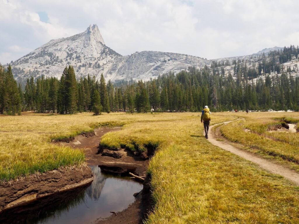
2. Tuolumne Meadows to Devils Postpile (~34 miles)
- Starting Point: Tuolumne Meadows Visitor Center in Yosemite National Park
- Ending Point: Devils Postpile in Mammoth Lakes, CA
- JMT Miles: Mile 21 to 56.6
You can beat the crowds of Yosemite Valley by starting your John Muir Trail section hike in Yosemite’s quieter Tuolumne Meadows. You’ll conquer Donahue Pass and Island Pass while also walking alongside several stunning alpine lakes including Garnet Lake, Gladys Lake, Rosalie Lake, and Thousand Island Lake. Thousand Island Lake was a prominent subject of some of Ansel Adam’s most famous work.
Pro Tip: If both of the above routes sound great, keep in mind you could easily connect them for a 60-mile trip!
Transportation Options Between Trailheads
You can’t park a car during the high-season summer months at Devils Postpile, so you’ll have to take the $8 shuttle that leaves and returns from Mammoth Ski Resort. Tickets can be purchased at the Mammoth Mountain Adventure Center.
I took this shuttle when I was dropping off my resupply, and found it to be very simple. To get from Mammoth Lakes to the Tuolumne Meadows Visitor Center, you can take YARTS.
Permit Information
Yosemite wilderness permits are required for any overnight trips in Yosemite. Permits are available through an advanced lottery system 169 days (24 weeks) prior to your start date. Check the NPS website for more information and for permit applications. There is a quota for Donahue Pass, which limits the number of hikers exiting Yosemite Valley to 45 per day.

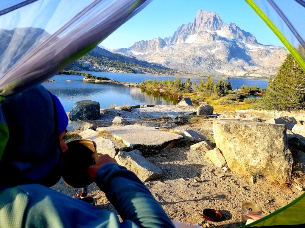
3. Purple Lake to Big Pete’s Meadow (~84 miles)
- Starting Point: Duck Pass Trailhead in Mammoth Lakes, CA
- Ending Point: Bishop Pass Trailhead at South Lake in Bishop, CA
- JMT Miles: Mile 70.5 to 134.5
This is one of the longer John Muir Trail section hikes and hikers are rewarded with non-stop scenery. You’ll climb through Evolution Basin up the infamous Muir Pass and get to visit Muir Hut, all named in memory of the naturalist John Muir. You also get to climb Silver and Seldon Passes and enjoy some incredible campsite opportunities at the gorgeous Purple Lake, Lake Virginia, Bear Creek, McClure Meadow, and Big Pete’s Meadow.
The hike up out Le Conte Canyon and out over Bishop Pass is a big one. I’d suggest planning for a night in Dusy Basin on the way out. If this section is too long, you can reduce the section to 57 miles by starting at the North Lake Piute Trailhead.
Transportation Options Between Trailheads
From Mammoth Lakes, CA you can take the free Orange Bus Line (Lakes Basin Trolley) to stop 100 which is right along the shore of Lake Mary. From there it’s a short hike uphill through the Coldwater Creek Campground to the parking area where you’ll find the Duck Pass Trailhead in the uppermost corner of the parking lot. For transportation between Mammoth Lakes and Bishop, Eastern Sierra Transit offers shuttles Monday-Friday.
Permit Information
Permits need to be secured through Inyo National Forest. Advance permits are available online 24 weeks ahead of the start date. Walk-up permits are made available online two weeks before the start date or in person at some ranger stations–call ahead to check.
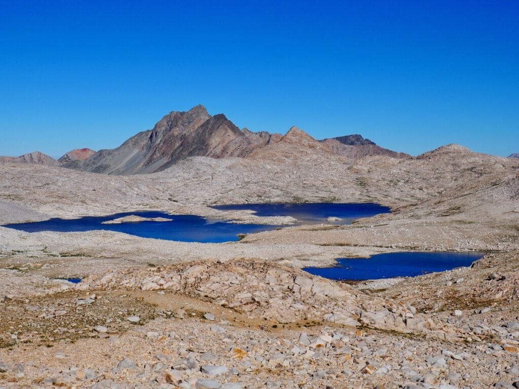
4. Big Pete’s Meadow to Kearsarge Pass (~65 miles)
- Starting Point: Bishop Pass Trailhead at South Lake in Bishop, CA
- Ending Point: Onion Valley Trailhead in Independence, CA
- JMT Miles: Mile 134.5 to Mile 177.9
This is an epic section hike of the JMT and you should plan for at least 5 days to complete this route. You’ll cross over three 12,000 foot passes, Glen Pass, Pinchot Pass, and Mather Pass, as well as travel through the stunning Kings Canyon National Park. You’ll also tramp through LeConte Canyon, Grouse Meadows, and conquer the Golden Staircase.
Make sure to camp at Middle Rae Lake for a night. While it’s a slightly busier site, the morning reflections of the Painted Lady make it worth it. The exit over Kearsarge Pass isn’t too bad and there are some nice lakeside campsites on the east side of the pass. I suggest Flower Lake for your final night of camp. You also get to experience two awesome trail towns, Lone Pine and Bishop!
Transportation Options Between Trailheads
Hitchhiking from Onion Valley trailhead is fairly simple since this is a commonly trafficked area and there is a large campground at the bottom of the road as well. You might have to hitch into town (Independence or Bishop) and then hitch to the other trailhead.
The best option would be to take two cars and drop one at the Onion Valley trailhead then drive to Bishop Pass trailhead to park. It is about an hour’s drive between the two trailheads. As of 2023, East Side Sierra Shuttle also offers transportation between the two for $260 for the first 2 passengers and $50 for each additional passenger.
Eastern Sierra Transit also runs buses between Independence and Bishop Monday-Friday and twice-daily shuttles from Bishop to South Lake, where the Bishop Pass Trailhead is located.
Permit Information
Since you’ll be hiking through Inyo National Forest & Kings Canyon National Park you’ll need a permit. The great news is that since the trail starts in the Inyo National Forest and NOT in Kings Canyon National Park, your Inyo Wilderness permit is good for the entire itinerary of your hike.
4. Rae Lakes Loop (~40 miles)
- Starting Point: Road’s End in Kings Canyon National Park
- Ending Point: Road’s End in Kings Canyon National Park
- JMT Miles: Mile 169.1 to Mile 181.8
This classic High Sierra loop only travels 12 miles of the John Muir Trail–between Woods Creek and Bubbs Creek–but it’s a bucket list route due to its incredible diversity of gorgeous scenery from river canyons to waterfalls to high alpine lakes and mountain passes.
The loop passes by the Rae Lakes, one of the most scenic lake basins on the whole JMT. Most people hike this loop in 3 or 4 days and since it’s a loop, the logistics are easy; you will start and finish at your car at Road’s End in Kings Canyon National Park, eliminating the hassle of setting up a shuttle.
When planning this trip, keep in mind that Road’s End and Kings Canyon are on the west side of the Sierra, which may be more or less convenient for you, depending on where you’re coming from.
Permit Information
Since this loop starts and ends in Kings Canyon, you will need a permit through Sequoia-Kings Canyon National Park (which are jointly managed). Wilderness permit reservations are available at Recreation.gov up to six months in advance of your entry date, released daily at 7am, Pacific Standard Time.
In 2023, walk-up permits will be available on Recreation.gov and from the Road’s End Ranger Station, starting at 1 pm the day before your trip. Only five walk-up permits are available per day for this trailhead, unless there are cancellations or no-shows. In 2023, the fee is $15 per permit, plus $5 per person. Credit cards are preferred.

6. Kearsarge to Whitney Portal (~49 miles)
- Starting Point: Onion Valley Trailhead in Independence, CA
- Ending Point: Whitney Portal out of Lone Pine, CA
- JMT Miles: Mile 177.9 to Mile 222.4 (the southern terminus of the JMT)

If summiting Mt. Whitney is important to you then this is the John Muir Trail section hike for you! You’ll also have the opportunity to climb Forester Pass, the highest point on the Pacific Crest Trail, as well as visit Crabtree Meadows at the base of Mt. Whitney. Allow at least 5 days for this route.
This southernmost route along the end of the JMT takes you from Onion Valley over Kearsarge Pass to the highest point in the continental United States. Another highlight of this section is that you get to climb Whitney from the back and exit out the portal from the front. Day hikers on Whitney typically only climb up and back down the portal route.
Transportation Options Between Trailheads
There are frequent shuttle services that will transport you from Whitney Portal to the Onion Valley campground. Hitchhiking this distance is also very common.
Permit Information
Permits are required for this section since you’re starting at the Onion Valley trailhead and hiking through the Inyo Forest on an overnight trip. Permits can be reserved online up to 24 weeks in advance. You’ll need to use the Inyo National Forest- Wilderness Permits and search for a permit that starts at “Kearsarge Pass” and “Exits Mt. Whitney” via Mt. Whitney (Trail Crest Exit). You’ll need to know your start date and your exit date to obtain permits. Planning is key for this section hike.
READ NEXT
Curious about a JMT thru-hike? Here’s our top John Muir Trail posts:
Have you hiked one of these John Muir Trail section hikes? Which one is your favorite and why? Leave a comment below!

I love your web pages on Best Section Hikes on the John Muir Trail
I’m unable to bring up “For more info check out my detailed” for section 2:
https://bearfoottheory.com/john-muir-trail-highlights-2/ (broken link)
So sorry about that Charles. The link has been fixed! Here is the link as well: https://bearfoottheory.com/best-of-john-muir-trail-part-2/
what is weather on JMT mid june?
thisis the time i have free.
Hi Amy, it really depends on the year and snowpack. Mid-June can usually be very heavy with snow and the creeks can be high for river crossings but again it varies yearly.
Any thoughts on Reds to LaConte? We did Happy to Reds this year.
I have hiked the JMT in sections, most sections multiple times.
Consider also the following in-and-out JMT section treks:
Reds Meadow to Edison Lake (Vermillion Valley Resort) and back.
Florence Lake (Muir Trail Camp) to LeConte Ranger Station and back.
The advantage is that they require one vehicle and they can be done in a week without resupply.
Which is the easier section? For someone inexperienced (begainner), in 40s and a bit out of shape?
We’d say Tuolumne Meadow to the end of Lyell Canyon is the easiest stretch. It’s about 8 miles long and is relatively flat. Hope that helps!
Hi Kristen! I am also Kristen…with a E! My sister and I are working on planning a JMT Section hike. We want to start in Yosemite Valley (being from the East Coast we have never been) and ending at Reds Meadow. From my calculations it looks like about 86-90 miles total…we would plan on doing this in about 10 days. What are your thoughts? Resupply suggestions?
Any advice you have would be greatly appreciated.
Hey there, Kristen!
You and your sister are going to have an incredible time. The distance between Yosemite Valley and Red’s Meadow is actually about 60 miles. If you start in Yosemite Valley, a resupply at Tuolumne Meadows is your only option before Red’s Meadow. For Kristen’s complete JMT Resupply strategy, check out this post: https://bearfoottheory.com/john-muir-trail-resupply/. (Keep an eye out in that post for the mention of Tuolomne Meadows.) Have an awesome time! P.S: My favorite parts of that area are Cathedral Lakes and Cloud’s Rest. – Mary Kathryn
Hey there, which direction would you recommend doing the Onion Valley to South Lake section of the JMT — northbound or southbound?
Thanks!
Martin
Hey Martin,
That section of the JMT is packed with beautiful scenery, so you can’t go wrong in either direction. Though it’s much (much!) easier to get a northbound permit for any section of the JMT – your chances of getting one are greater. Enjoy your trip!
Hi Kristen,
How do you get the walk up permit from Onion Valley to Whitney Portal?
Hi there!
This is Mary Kathryn responding on Kristen’s behalf. The Inyo National Forest Service distributes permits for this section of the JMT so you’d get it from them. Here’s their direct number for more information: (760) 873-2483. Happy trails! – Mary Kathryn
Is it possible to do a round trip section hike from Devils Postpile to Tuolomne and back with one application? Or, does this require two applications?
An overnight permit should be fine for an out-and-back hike from Devils Postpile, but check the US Forest Service website to be sure.
Wow…things have sure changed! I grew up backpacking in the High Sierra back country with my dad in the ’50s and ’60s. Back then, not only did you NOT need a permit to be in the mountains – we rarely saw another human being for the two to three weeks that we would be out there, except for an occasional ranger on horseback. I’m glad that more people are out there experiencing the unique beauty that the ‘Range of Light’ offers, but not thrilled that the JMT has become a pedestrian super highway.
What’s the best route if you only have 5 days around end of Sept/ 1st week Oct, and shuttles available back. We are experienced hikers/ mountaineers. No more available permits for Mt Whitney.
One of Kristen’s favorite sections of trail is Big Pete’s Meadow To Kearsarge Pass. It’s 65 miles, so you would have to do big days. Alternatively, you could exit before Independence (Big Pine could be a good choice). We cover shuttle options in this post
Love this post, thanks so much for the info. We are looking to do a two week jaunt on the trail. We’re all experienced east coast hikers, not afraid of miles but want to enjoy our time as well.
Purple Lake > Kearsage seems too good to pass up. At nearly 150 miles is there anything you’d recommend dropping off either end, to drop somewhere between 20 – 40 miles? We plan to utilize shuttles hopefully.
Thank you!
Hi Pete, You can shave off about 20 miles by starting at North Lake Piute Trailhead instead of Duck Pass. Enjoy your trip!
Hello, thanks for all the info and this cool page.
WE are considering a section hike & we are leaning toward Duck creek to Kearsage Pass, over 2 weeks of hiking. Wondering your thoughts on this, or if you’d recommend a different route. We are planning to utilize some sort of shuttles etc,
Thanks for your help!
Hi Peter, thanks for reading! The JMT is amazing and Duck Creek to Kearsarge Pass is an awesome section full of non-stop scenery. I don’t think you’ll be disappointed with that choice.
Hello Kristen,
Really enjoyed your post!!! It is helping a lot in our planing of JMT section hike this June. We are a family of three, and sort of experienced hikers from east coast. We have done multiple 2-3 nights section hikes on Applachian Trail. And my son who will be 12. He has hiked to more than 15000 feet in Ecuador before. He also did a 5000 feet day climb with his backpack in Acatenango Volcano in Guatemala. We are wondering:
1. If we are open to one 4 nighter, or even a 5 nighter, with the rest around 3 nights, what are the top three sections you thing we should not miss on JMT?
2. Is first half of June better for these sections hikes, or the second half is better, and why?
3. Do you think a rental car will still help tremendously as from what i read the public transportation is pretty good in that area?
Many thanks in advance, please keep up your excellent work!
YIcheng
Hi Yicheng, I think you can’t go wrong with any sections of the JMT, but my top 5 are on this list. I hiked the JMT in August so I can’t really comment on whether the beginning of June or end of June would be better, but the thing to keep in mind with early summer is mosquitos. Be prepared for bugs (I recommend bringing a head bug net just in case) although it varies year to year when they are most prominent. With COVID, I would double check public transportation and shuttle schedules, but you can find detailed transportation info here: https://bearfoottheory.com/john-muir-transportation-information-planning-tips/
Sounds like an amazing trip you have planned with your son – enjoy!!
Hello Kristen
My son (22) ,son-in-law (32) and myself (M59) will be backpacking over Kearsarge Pass from Onion Valley June 13 2022. I know we may still have snow in some parts then and will be prepared for that. Is it difficult getting a Whitney pass from the back side? I would love to hike up Whitney sometime. Would this be the better hike this time of year or should we go north top Red’s Meadow?
Thanks!!
Hi Alan, I hiked the JMT in August so I haven’t personally hiked Whitney or this section of the Sierras in June and can’t speak to the snow or permit difficulty, unfortunately.