John Muir Trail Transportation Guide & Planning Tips
Learn about the cheapest and most efficient John Muir Trail transportation options, including the best airports & bus options.
Ok… so you got your John Muir Trail permit, planned your resupply points, and got your gear lined up. Congrats! You’re almost ready for the best backpacking trip of your life. But don’t lace up those boots just yet… you still have a few more logistics to take care of, one of which is your John Muir Trail transportation plan: How will you get to and from the trail at the start and end of your hike?
John Muir Trail transportation is pretty simple if you have two cars and two people to drive. Simply drop one car off at one end, drive the other up to your permitted trailhead, and after your hike run a shuttle back up to your starting point.
But what if you are going solo, don’t have two cars, or are flying in from somewhere far away? Fortunately, the Eastern Sierra has very good public transportation but you will need to plan ahead a bit to arrange shuttles or reserve seats. In this John Muir Trail Transportation Guide, you’ll find all of the information you need to plan your public transportation logistics for your John Muir Trail hike.
This blog post was originally written by BFT Founder, Kristen, who hiked the John Muir Trail Southbound in 2014. It was updated in 2022 by Mary Caperton Morton of The Blonde Coyote who hiked the John Muir Trail Northbound in 2020. It includes the most recently available information.
This post may contain affiliate links.
Which Direction Are You Hiking the John Muir Trail?
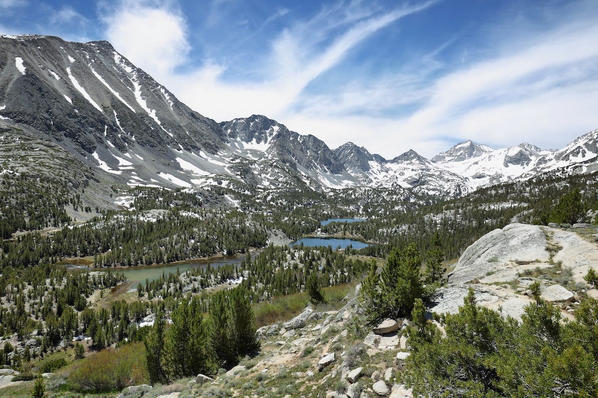
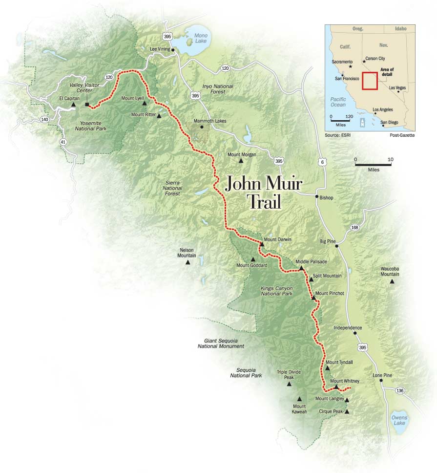
The 212-mile John Muir Trail runs from Yosemite to the Whitney Portal trailhead just south of the 14,505’ Mt. Whitney. The most popular direction for John Muir Trail hikers is North to South because you are able to adjust to the altitude more gradually (the passes and peaks get taller as you move south towards Mt. Whitney). You’ll need to decide which direction you will be hiking the JMT before you get your permit as permits are assigned based on your starting trailhead.
>> Read Next: How To Apply for a Southbound JMT Permit
The JMT transportation logistics are somewhat easier in Yosemite, as public transit and parking are readily available, and you also have the opportunity to explore the park before and after the hike if you have extra time.
On the other hand, southbound John Muir Trail permits are becoming harder to come by, so many people are opting for a northbound John Muir hike departing from Horseshoe Meadow, just south of Whitney. Horseshoe Meadow is not accessible by public transportation, but there are several shuttle options from Lone Pine which we’ll talk about below.
Save this post!
Enter your email & I'll send this post to your inbox! You'll also receive my weekly newsletter full of helpful advice for planning your adventures.
Closest Airports to the John Muir Trail
Mammoth
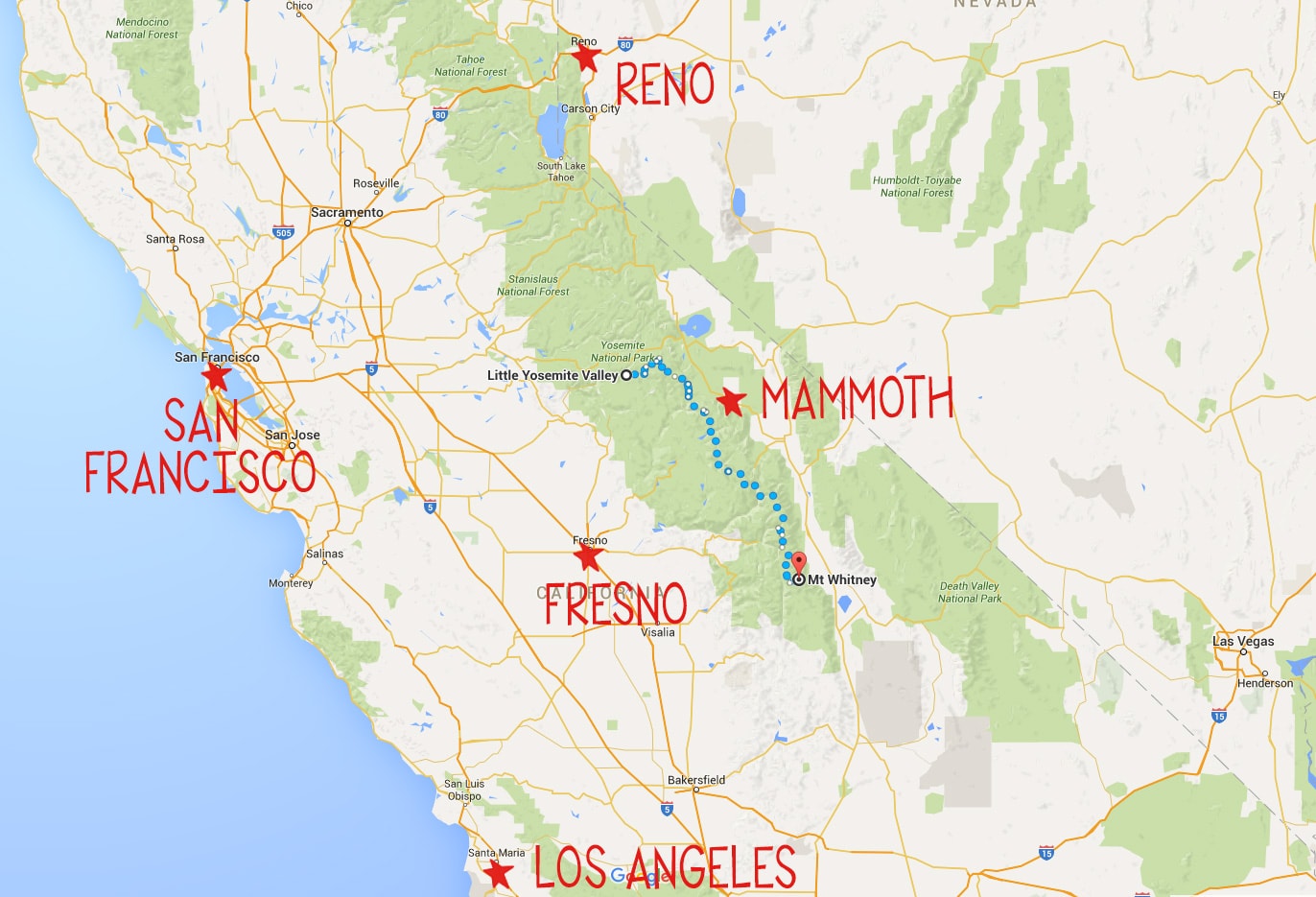
If you don’t live out West and you plan on flying into California to start your hike, the easiest airport to fly into is Mammoth airport. Conveniently situated on the eastern side of the Sierras between Yosemite and Mt. Whitney on Highway 395, there is frequent public transportation that you can use to get to and from the JMT. What’s more, Alaska Airlines and United serve this airport, so you can pretty much get to Mammoth no matter where you are coming from. The only downside to Mammoth is that fares can be a bit more expensive than larger airports, but you’ll make up for it in convenience.
Reno
The second best option is the Reno airport. However, getting to Yosemite from Reno requires a transfer in Mammoth, and Reno is several hours further from the endpoint at Mt. Whitney (assuming you are hiking north to south) than Mammoth.
San Francisco, Oakland, or Los Angeles
Major airports on the west side of the Sierras – like San Francisco, Oakland, or Los Angeles – may have cheaper flights, but they are substantially more difficult to get back to since you will finish your hike on the east side of the Sierras, requiring a very long drive around to the other side.
Amtrak connects to YARTS (more on YARTS below) in Merced if you want to look at train/bus options. I’m not going to detail these routes since they require multiple transfers between trains and buses. If you want to fly into one of these airports, Rome2Rio is a helpful public transportation planning tool that you can use to figure out the best route from SFO, OAK, or LAX.
Regional Airports
Other regional airports like Fresno-Yosemite or Merced don’t offer the same convenient transit options and also aren’t any cheaper.
All airports (Mammoth, Fresno, and Merced included) have car rentals available if you want to rent a car… but leaving a rental car at a trailhead for 2-3 weeks doesn’t seem that economical.
>> Read Next: How to Resupply on the JMT
Shuttle & Public Transportation Options for Getting to and from the John Muir Trail
From Mammoth Airport:
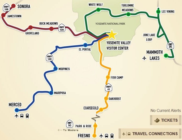
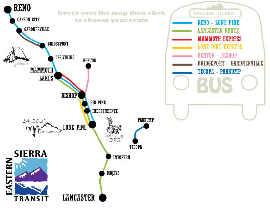
If you are going to fly round trip to the Mammoth Yosemite Airport, then public transit is a great, easy, and cheap way to get to the JMT and back to the airport at the end. Just take a taxi into Mammoth Lakes, where you can pick up the Yosemite Area Regional Transit (YARTS) HWY 120/395 bus from Mammoth to Yosemite Valley (the line shown in GREEN on the map below). The bus runs daily from mid-June to mid-October (as long as Tioga Road is open) and you can get dropped off either in Tuolumne Meadows or Yosemite Valley, depending on which trailhead you have a permit for. If you go all the way to Yosemite Valley, the bus ride takes about 4 hours. Advance tickets are highly encouraged.
Getting back to the Mammoth Airport: At the south end of the John Muir Trail, you exit at the Whitney Portal trailhead. There is no public transportation that goes directly to the trailhead, so you’ll need to hitchhike out to the nearest town of Lone Pine. It’s about a 20-minute ride, and with all the people hiking to the Whitney summit every day, hitching a ride is common practice and you shouldn’t have to wait that long. That said….always trust your gut and don’t get in the car with anyone you don’t feel comfortable with.
If you don’t want to hitchhike or you have a large group, there are a few private shuttle options that offer rides to/from Horseshoe Meadow or Whitney Portal to Lone Pine:
- East Side Sierra Shuttle offers rides from the Whitney Portal or Horseshoe Meadow to Lone Pine.
- The Lone Pine Chamber of Commerce
- Kurt Power: contact Lonepinekurt@aol.com (preferred) or call 661-972-9476. Kurt has limited availability but can also help connect you to other private shuttle drivers in the area
- Climber.org offers a list of Sierra shuttle options, some of which will apply to JMT hikers
Once you’re in Lone Pine, you can take a 2-hour Eastern Sierra Transit bus back to Mammoth. There are two different lines that will get you there:
- The Lone Pine-Reno line leaves Lone Pine at 6:10 am and runs Monday to Friday
- The Lancaster Route leaves at 5 pm and runs Monday to Friday
- Unfortunately, there is no weekend bus service, so plan accordingly
- Reservations are also recommended. Call 800.922.1930 to reserve your seat
- Double-check these days/times on their website, as schedules do change
If you want to skip the bus, East Side Sierra Shuttle will pick you up at the Mammoth Airport, drop you off in Yosemite, and then pick you up at Whitney Portal and take you back to the airport. This is an awesome (but expensive) way to take the hassle out of the travel, especially if you have a bigger group.
>> Read Next: JMT Gear List
From Reno Airport:
Getting to the John Muir Trail: If you are starting in Yosemite, you’ll need to take a 4-hour Eastern Sierra Transit bus from Reno and get off in Lee Vining or Mammoth. Mammoth is the last “major” town to get last-minute supplies such as gear and backpacking food, so if you think you need to pick anything up, plan on stopping in Mammoth.
Then once you are in Lee Vining or Mammoth, transfer to the Yosemite Area Regional Transit (YARTS) HWY 120/395 bus. As mentioned above, the YARTS bus runs daily mid-June to mid-October (as long as Tioga Road is open) and you can get dropped off either in Tuolumne Meadows or Yosemite Valley, depending on which trailhead you have a permit for. If you go all the way to Yosemite Valley, the bus ride takes 4 hours. Advance tickets are highly encouraged.
Getting back to the Reno Airport: Once you are in Lone Pine, you can take a 6-hour Eastern Sierra Transit bus all the way to Reno.
- The Lone Pine-Reno line leaves Lone Pine at 6:10 am, Monday to Friday.
- Unfortunately, there is no weekend bus service, so plan accordingly.
- Reservations are also recommended. Call 800.922.1930 to reserve your seat.
- Double-check these times on their website, as schedules do change
Parking Options for the John Muir Trail
Another option if you have only one car is to park it at one end and then take public transportation to the other end. But where do you leave your car? Fortunately, there is long-term parking available near both the north and south terminus of the JMT.
Yosemite National Park
There is free long-term parking available in the Curry Village backpacker’s lot near the Happy Isles trailhead and at Tuolumne Meadows in the Wilderness Permit lot. Make sure to check in first before parking and if you have any questions about parking, just ask the ranger. Also, make sure you don’t leave any food in your car, and instead place any scented items in the parking lot bear lockers.
Whitney Portal
JMT hikers will find limited free parking at the Whitney Portal trailhead, although the lot does fill up and you may need to wait for a spot. Never leave food or scented items in a car anywhere in the Sierra! Black bears are notorious for breaking into cars. Use the provided bear boxes and be sure to date any food that you leave or it will be thrown out. For more information on current road conditions up to the Whitney Portal, visit the Inyo National Forest website.
Horseshoe Meadow
There is also free long-term parking available at Horseshoe Meadow if you choose to begin or end your hike at the next trailhead south of Whitney Portal. Some hikers elect to start their trek here, as it’s easier to get permits from Horseshoe Meadow than Yosemite or Whitney Portal. Heed the warnings about leaving food in your car. Bear boxes are provided.
Lone Pine
If trailhead parking options are full or if you’d rather leave your car in town to avoid bear break-ins, the small but hiker-friendly town of Lone Pine has several paid options for long-term parking. Both the Chamber of Commerce and the Dow Villa Motel offer parking for a small fee.
Related Blog Posts:
- Complete John Muir Trail Planning Guide
- How to Apply for a Southbound JMT Permit
- 3 Week John Muir Trail Itinerary
- JMT Maps, Apps, Books, & Resources
- John Muir Trail Gear List
- How to Resupply on the JMT
>> See our entire John Muir Trail archive
What questions do you have about John Muir Trail transportation? And if you’ve hiked the JMT, leave any tips in the comments below!
Kristen,
We are hiking in this year at Rush creek and exiting at Bishop Pass. Do you have any suggestions on transportation? We plan on leaving a car at Bishop TH but need to get to the Rush Creek Campground to start oyr hike. Any help would be appreciated.
Hey Stephanie – I’m not sure of any public transportation for Rush Creek. I will tell you I was just in the Bishop area and saw lots of people hitchhiking. We actually picked up one guy who ended up being a PCT thru-hiker. I can’t tell you whether or not that’s something that is safe or you should feel comfortable with…but I now a lot of people do it.
EXACTLY what i needed! Thanks so much!
I’m trying to plan a trip from Muir Trail Ranch NOBO to Happy Isles. What’s the best way to get to MTR from either San Francisco or Fresno?
Great question Jason, here is a link to information on driving to Muir Trail Ranch from NorCal! Have an awesome hike!
I’m starting at VVR and going south to Whitney portal is there any public transportation back to Yosemite or better yet Fresno?
You can get transport back to Yosemite using the public transportation options in this post. Fresno is a little bit harder because it’s on the other side of the Sierras
What do you think of leaving a car in mammoth, busing to the Yosemite valley, then busing back to mammoth from Lone Pine? I live 6 hours away from Mammoth but not sure taking two cars that far is the best option…
Hey Sarah,
I think that’d be a fine option. But maybe you just leave your car in Yosemite and bus all the way back. Or vice versa. That way you only have to bus one way?
Hi Kristen, Long time lurker on your site. Just wanted to say thank you for this great post (and all of the other ones!). We are applying about to apply for a September start date heading southbound and all of your JMT info has been MUCH appreciated. Fingers crossed for the lottery!
Kristen:
I appreciate your blog and all the info on the John Muir trail. We are doing the trail this year and changed our plans to go Northbound beginning July 10. With the extra ordinary amounts of snow this year they are predicting rough river crossings. My question to you would be what stream/river crossings would you be concerned about. I am keeping up with a lot of blogs to see what current conditions are but wanted to get your thoughts.
Thanks
Pat
Hey Pat – It’s hard to say as I did the trail in mid-September in a below average snow year. I’d recommend asking in the JMT facebook groups as there are a lot of knowledgeable folks in there.
Hi Kristen – Great blog. I’m hiking the JMT in late September and my friend wants to join me the last few days and climb Whitney (I have an extra permit). I was wondering if you had any suggestions for a meeting point? From what I’ve been reading it seems like Onion Valley would be good perhaps? Is there parking there? Any suggestions would be much appreciated! Thanks so much.
Hey Jeri! Great to hear you are hiking in late September, hopefully, this year’s snow pack will be significantly melted by then. We wish you best of luck on your trek. There is plenty of parking available at Onion Valley.
Hi Kristen,
My mom and I have a permit to hike the JMT section from Yosemite Valley to Reds Meadow starting Sept 29-Oct 5. It will be our first time doing a backpacking trip. Our plan was to do a resupply in Tuolumne Meadows to save on weight but we are now realizing they won’t be open after Sept. 15. We were told that if we leave a resupply in a bear box in the parking area as previously suggested in your blog, rangers check those often and dump it! I think we can get 6-7 days of food in our bear canisters (we’ll definitely have to pre-pack to figure it out). The guy at Toulumne scared us when he said that the trail will be miserable during our planned trek, below freezing temperatures, we could get lost if there is sudden snow, AND if there is we’ll be stuck at Red’s Meadow unable to drive out (we plan on leaving a car in the long-term parking for the week). Now we’re kind of freaked out that we’ll run into some serious problems. I don’t know what to do. Do you have any suggestions on how we can navigate this? Thanks for any advice.
Hi Casey! Sounds like you and your mom have an awesome adventure planned. It looks like on your start date the weather in Yosemite Valley is going to be 70+ degrees and sunny. You are correct about Tuolumne Meadows but I would talk to a ranger about leaving a resupply in a bear box. Keep in mind if you do leave a resupply it should be marked and labeled with your expected pickup date. Who is “the guy at Toulumne”? Is he a ranger? This is from the Devil’s Postpile Monument NPS website, “There is no overnight parking in the Reds Meadow Valley or Devils Postpile after October 15. Backpackers need to arrange for a shuttle or taxi or be prepared to hike out. The road will not be plowed after October 15.” I would also try calling their ranger station. Your trip sounds great, just keep a watch on the weather predictions.
Hi,
We are planning the section hike from Purple Lake to Big Pete’s Meadow. Can you give me any ideas for transportation out at the Bishop Pass Trailhead at South Lake? We wwill most likely be going back to Mammoth. But could consider other transportation.
Thank you! I love this site. Can’t wait to get on the trail!
Ellen
Hi Ellen, so great to hear you are planning to section hike this gorgeous area. Check out this post (https://bearfoottheory.com/john-muir-trail-section-hikes/). We recommend taking the Orange Line from Mammoth, CA. Hope that helps!
My three sons and I are doing the JMT starting the end of July. What kind of pretraining schedule would you recommend for me? I’ll be 51 and consider myself to be in good shape but the elevations have me a bit worried. I’m not worried about my sons, age 15, 17 & 20.
Hi Anna, thank you for reaching out. We wrote an entire post on training for a thru-hike. Here is a link: https://bearfoottheory.com/how-to-train-for-a-thru-hike/ We are getting ready to also publish a piece in April on building your lung capacity. I recommend completing cardio activities at least 3x a week to build your lung capacity — this will help with elevation. Make sure your 15-year-old has some strength training and is prepared to carry his own gear for a month on his back. Best of wishes on the JMT! Have fun & take lots of photos!
Great guides, much appreciated!!
You mentioned that you parked at Whitney Portal (or Lone Pine). I didn’t see your explanation on how you then traveled to the trailhead in Yosemite. Maybe I missed it but that’s my plan. Recommendation?
Thanks
Hi Kristen. Great blog. My sister and I are going NOBO to HI out of VVR this year. We plan to fly into Fresno. Would we also want to fly out of Fresno to get home, or would SanFran be better? We will be ending our adventure on a Tuesday, so it looks like the YARTS to Mammoth Airport won’t work for us.
The Fresno Airport is significantly closer.
Hi Kristen
My friend and I are planning a thru hike from Whitney Portal to Happy Isles in mid July. I was thinking about leaving my car in Whitney Portal/Lone Pine. How do I get back from Yosemite to Whitney Portal/Lone Pine to pick up my car once I complete my hike?
Alternatively, is it better to drive to Yosemite first to leave the car there and then take public transportation from Yosemite to Lone Pine? Is there a direct bus from Yosemite to Lone Pine?
Hi Jag, we included this information in the post. You’d need to either arrange a shuttle or you’d need to take a combination of buses.
Hello!
My boyfriend and I are coming to California (from the UK) at the beginning of September and were planning on hiking the first bit of the JMT (from Happy Isles to Red’s Meadow). We did not know about the lottery permit system so obviously we do not have a permit… Do you know if it’s going to be possible to get a permit once we get there? I read about first come first served permits being given out from 11 am the day before the start of your trip, but not sure how to check the availability for those. Also, if we leave the car at the parking lot near the Half Dome Village, is there any transportation to get back there from Reds Meadow?
Thanks a lot!
I’m flying in from Chicago to Mammoth Lakes – does anyone have any suggestions on car rental – from pick up at Mammoth Lakes – to drop off at a car rental place (Whitney Portal?) – and take a shuttle/bus to Onion Valley Campground? Has anyone done something like that because I’m trying to figure out the logistics.
If I hike north to south and park at Yosemite, is there any transportation from Lone Pine back to Yosemite?
Hi Ann, from Lone Pine, you can take the Eastern Sierra Transit shuttle north on HWY 395 to Mammoth Lakes. The bus stop in Lone Pine is right outside of the McDonalds. Once in the Mammoth Lakes area you can then take the YARTS bus to Yosemite Valley. Best wishes!
I read your tip and try to follow and implement into my real life. Thanks!
Hey Kristen – A group of friends and I are doing a section of the JMT from Devils Postpile to Happy Isles. We are trying to figure out how to get transportation from Happy Isles to the Yosemite/Mammoth Airport to pick up a car to drive back to Reno to get on a plane back to NC. Do you have any suggestions for cheap transportation for us to get from Happy Isles to the Mammoth airport? Thanks!!
Hi Leslie, you’re going to need to connect a few of the options (public & private) to get between the two.
Good morning, I am a Belgium hiker who will do the JMT trail on july 2nd, i’m looking for transportation from san francisco to Tuolumne Meadows… any good idea? Uber, Lift or any other service i could use ?
Thanks
Hi Sébastien, we haven’t personally gone from San Francisco to Yosemite, but Rome2Rio is a good place to start for public transportation options (train/bus/shuttle etc options). You may have luck with Uber/Lyft but the drive is 4.5 hours so it may be hard to find a driver. Enjoy the JMT!
I need to get from Mammoth to Lone Pine on September 5th. It’s a holiday, so public transportation is not running. My permit is for the 6th out of Cottonwood Pass. Thank you
Hi Julie, unfortunately we’re not familiar with any other options. I’d recommend looking into local private shuttles or buses. Rome2Rio might be able to help for buses. Best of luck & enjoy your trip!
Thank you for putting together this brilliant brilliant article! In the process of finding transport options, I found that YARTS also serves Fresno-Yosemite airport. May be that changed since the article was last updated for that information, but it might be worth an edit.
https://yarts.betterez.com/cart/57f29bf6c241026a0b0001a1/trip-results?productFamily=reservation&productId=57f29bf6c241026a0b0001a2&type=oneway&channel=websales&departureDate=2024-09-08&from=58122922396e984509b5c806&to=65e8b79b1eab9e03aeb9d3ab&fares=57f29f8a185191e708cb534c%3A1