8 Best Hikes in Big Bend National Park
Planning a trip to Big Bend National Park? This post highlights my favorite hiking trails across Santa Elena, Chisos Basin, and Boquillos Canyon.
I’d heard a lot of great things about Big Bend National Park before I ever visited, but I wasn’t prepared for how cool and beautiful this place really is! As an avid hiker, the trails were what drew me in. The park is laced with over 150 miles of hiking trails ranging from short, paved paths to multi-day backpacking routes and everything in between.
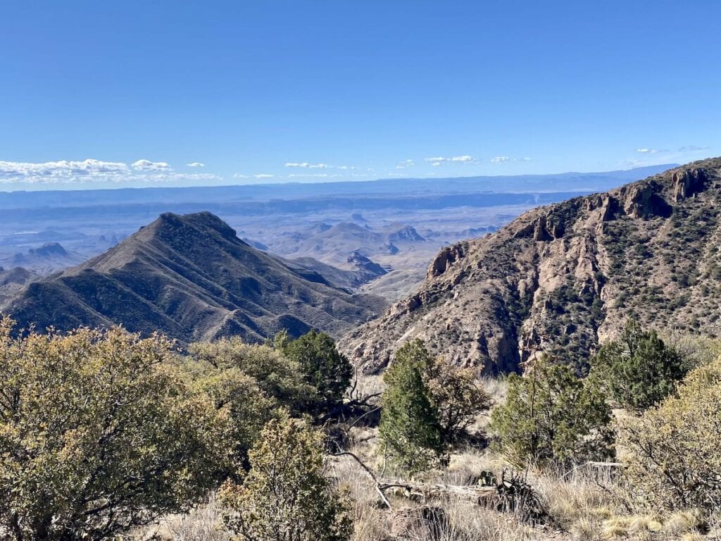
During my visit, I fell in love with the varied landscapes – depending on where I was in the park (which is huge), I hiked through forested mountains, expansive deserts, and deep canyons split by the Rio Grande River. The range of ecosystems and terrain in this park is incredible!
Big Bend National Park is a hiker’s paradise, and I encourage every outdoor adventurer to plan a trip to this unique place. I spent several days exploring the best Big Bend hikes and in this post, I share my top picks so you can spend more time out on the trail!
Planning a trip to Big Bend National Park? Be sure to check out my Big Bend Visitors Guide which gives you an overview of the Park and all of the things there are to do.
This post may contain affiliate links.
Big Bend National Park Layout
Big Bend National Park covers over 1200 square miles and is the 15th largest National Park (by size). Planning your hikes ahead of time is key to minimizing your driving time within the park and maximizing your time spent on the trails.
There are three main sections to the park:
- Boquillas Canyon in the East
- Santa Elena in the West
- Chisos Basin in the center
To drive from the East corner of the park (Boquillas Canyon) to the West corner (Santa Elena Canyon) takes at least 1.5 hours.

It is possible to combine hikes between these sections in a day, but it would be jam-packed and include a lot of driving. If you are limited on time in the park, I recommend focusing on hikes within Chisos Basin and toward Santa Elena Canyon – these were my favorite areas.
It’s also important to point out that Big Bend National Park has very limited facilities in the park, so be prepared with your hiking essentials ahead of time.
Save this post!
Enter your email & I'll send this post to your inbox! You'll also receive my weekly newsletter full of helpful advice for planning your adventures.
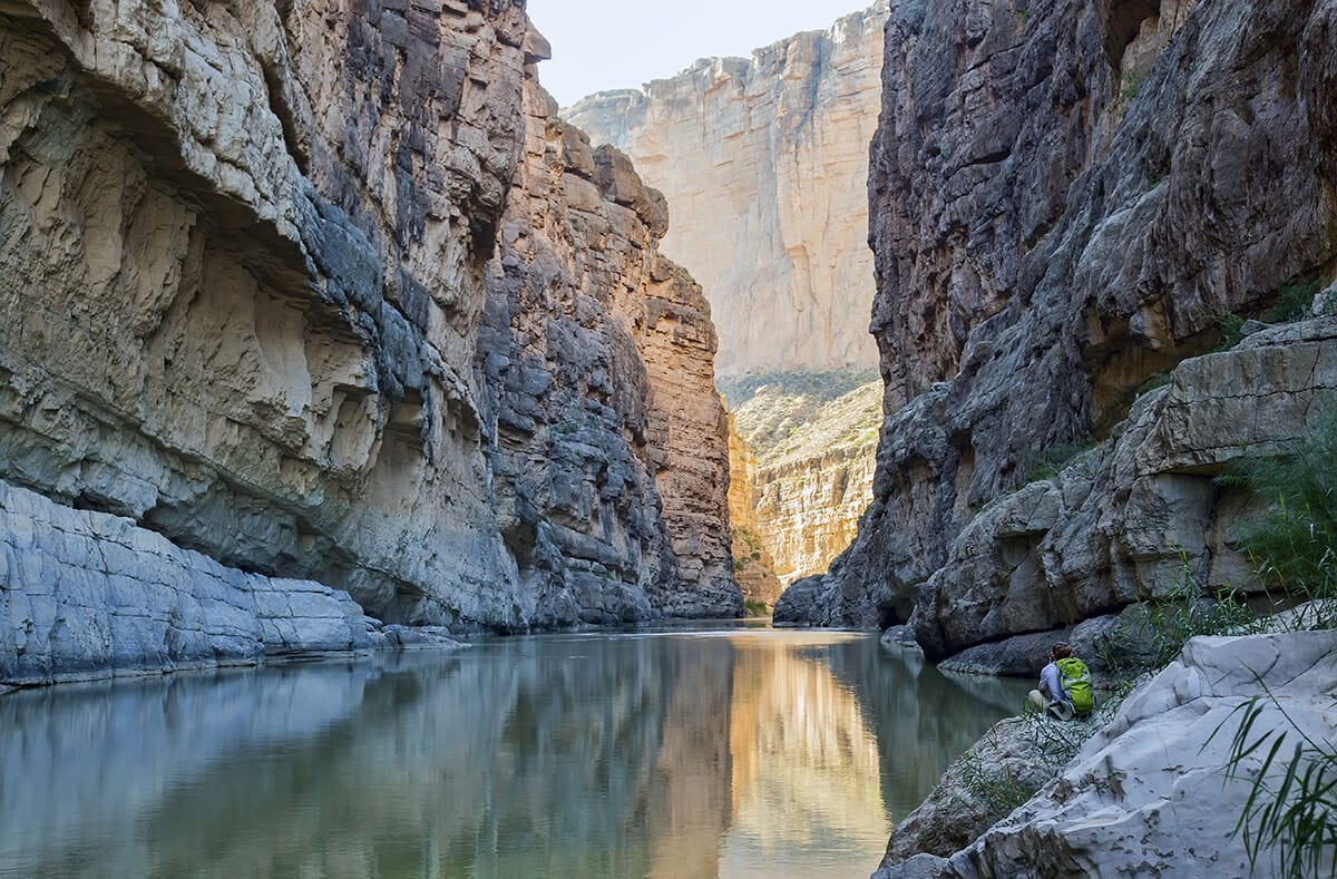
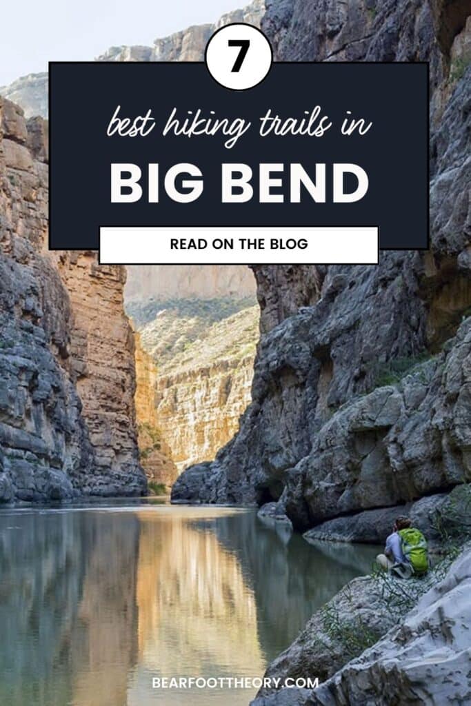
1. Santa Elena Canyon
Trail Basics
Trail Description
Even though it’s a short and relatively easy hike, the Santa Elena Canyon trail was one of my favorite (and also one of the most iconic) hikes in the park. Located at the end of the 30-mile Ross Maxwell Scenic Drive, Santa Elena Canyon begins at the mouth of a wide-set canyon.
From the parking area, I walked along a sandy creek for a stretch and then continued up paved stairs to a viewpoint of the canyon. From there, I descended down to the water’s edge until I reached a point where the canyon walls met the water and I couldn’t walk any further.
The canyon views all along this trail were spectacular! Note that the Santa Elena Canyon Trail can be muddy or closed off during the rainy season.
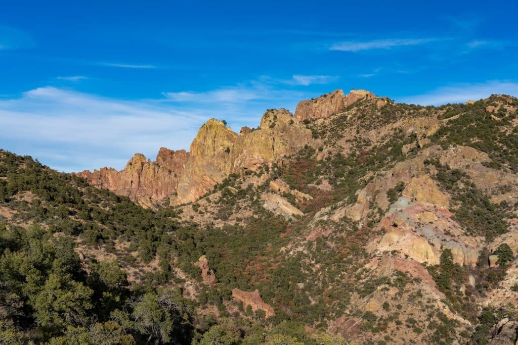
2. Chimneys Trail
Trail Basics
Trail Description
The Chimneys Trail is a beautiful and mostly flat path through the heart of the Chihuahuan Desert. One of the highlights of this trail for me was seeing all the desert vegetation – cacti, ocotillo, yuca, and more. It was beautiful!
The trail takes you out to the “Chimneys”, a group of tall rock spires that can be seen from the trailhead. At the Chimneys you can search for a panel of indigenous petroglyphs on one of the rocks. Please do not touch any rock art as it can cause permanent damage.
Technically the trail extends past the Chimneys for another 4.6 miles and ends at Old Maverick Road, but you would need to arrange a pickup on the other end.
This trail is fully exposed, so be sure to have adequate sun protection and lots of water.
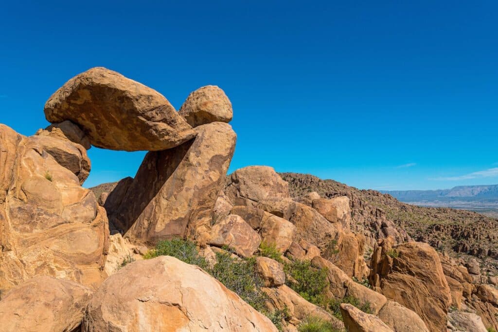
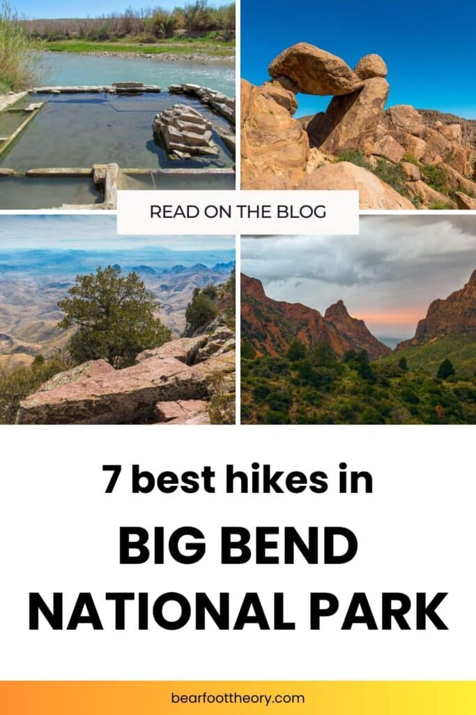
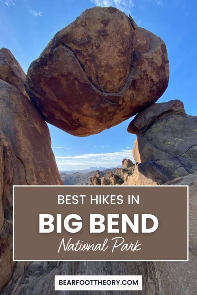
3. Balanced Rock Trail
Trail Basics
Trail Description
Balanced Rock Trail was one of my personal favorite hikes in Big Bend National Park. The views at the end of the trail are stunning and there are really cool rock formations.
This trailhead is located 6 miles down a dirt road – all vehicles should be able to make this drive unless it has recently rained.
Starting at Grapevine Hills trailhead, the trail weaves through jumbo boulders before climbing up to a group of rocks. This is where you’ll see the ‘balanced rock’ between two larger boulders. It creates a perfect frame of the desert in the distance.
4. Lost Mine Trail
Trail Basics
Trail Description
Lost Mine Trail is a very popular introduction hike to the Chisos Mountains landscape. But don’t let its popularity steer you away – the views from the saddle (about 1 mile in) will give you amazing views over Casa Grande and Juniper Canyon.
This trailhead has extremely limited parking, so I recommend starting this hike early in the morning to guarantee you get a spot.
You can stop at the viewpoint, but I decided to continue on and do the full hike. I encountered a few rocky switchbacks up to the summit but was rewarded with views all the way to Mexico.
5. Window View Trail
Trail Basics
Trail Description
The Window View Trail is a paved walking path that starts from the Chisos Basin Visitor Center. It’s wheelchair accessible and has excellent views of the Chisos Basin mountains. I recommend doing this walk at sunset – watching the sun go down through the natural “window” is beautiful!
If you want to make it into a longer hike, you can actually hike out to the window via Window Trail, which is 5.5 miles and ends at the “v” notch you can see from the trailhead.
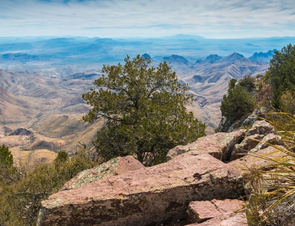
6. South Rim + Emory Peak
Trail Basics
Trail Description
If you are looking for a challenging all-day hike (or want to do an overnight backpacking trip), the South Rim loop (with the optional summit to Emory Peak, the park’s highest point) is a must. I did the full loop/summit in 1 day and it was the highlight of my trip.
If you want to summit Emory (elevation 7,800 feet), start the loop clockwise by following the Pinnacles trail from the visitors center. This way, you climb Emory Peak early in the day when your legs are fresh.
Alternatively, If you plan to bypass the detour up to Emory Peak, the elevation change will be more gradual on the South Rim loop by starting counterclockwise following the Laguna Meadows trail.
You can also make the hike shorter by cutting through on Colima Trail, but this will mean missing out on the views at South Rim, so I only recommend doing this if your goal is to summit Emory.
There are several backcountry campsites located along this loop that can be booked ahead of time (you can also usually get last-minute backpacking permits in person at Panther Junction or Chisos Mountain Visitor Center).
Tip: during Peregrine Falcon nesting season (usually February to May), the Northeast and Southeast portions of the South loop trail are closed.
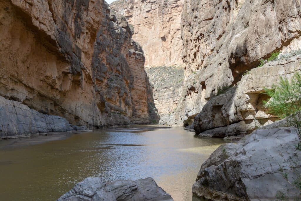
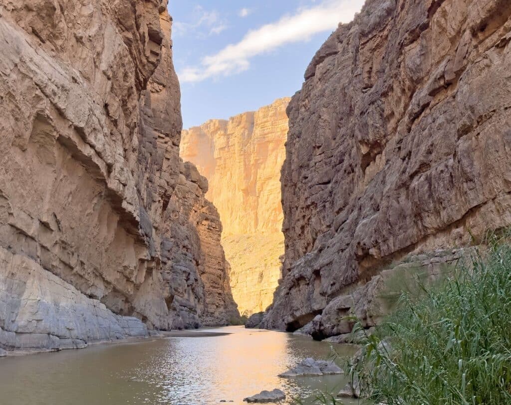
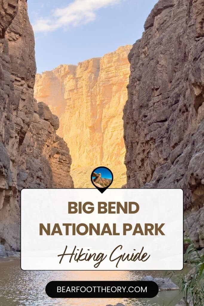
7. Boquillas Canyon
Trail Basics
Trail Description
Boquillas Canyon is another beautiful deep canyon hike along the Rio Grande. The water along this trail is quite shallow and a light aqua color – much different than the canyon and water at Santa Elena. I was happy I did both of these canyon hikes during my trip because they were quite different.
From the parking lot, the trail climbs up and over a cliff overlooking the water. As I descended the gradual slope, the trail parallels the river’s edge until the canyon walls meet the river and I couldn’t walk any further.
8. Hot Springs Historic Trail
Trail Basics
Trail Description
This trail is interesting for two reasons:
- You can learn about the families that inhabited this area and pass an old homestead along the historic trail.
- There is a 105-degree natural hot springs pool at the end that you can soak in.
However, both of those things being said, this wasn’t my favorite hike in Big Bend. It’s a popular area and you will most likely be sharing the hot spring with other visitors, so don’t expect peace and quiet.
But if you enjoy history and want to dip your toes in the warm water, it might be worth adding to your list of hikes to do in Big Bend.
Frequently Asked Questions
Big Bend National Park is open year-round, but I think spring (March- May) is the best time for hiking. The temperatures in spring are still mild (especially in the higher-elevation mountains) and it’s a great time to see wildflowers and wildlife.
Most of the trails in Big Bend National Park are not shaded, so make sure you’re dressed for desert hiking and carry plenty of water. The environment here can be very dry and hot, so it’s better to be overprepared than underprepared.
That depends! I spent about a week in Big Bend and while I was able to do all of the hikes I wanted to, there were still plenty more trails to explore. If you want to explore all three areas of the park, I recommend at least 5 days to make the most of your time there.
Other Hikes in the Southwest
Save this post to Pinterest
Are you planning a trip to Big Bend National Park or have you been hiking there? Share your questions, comments, and experiences below!
You should check out Mesa de Anguila if you want to avoid the crowds.
Thanks for that tip, Rick!
Emory Peak is an all-day hike for the average person and requires a tiny bit of climbing at the end, but it’s worth it for all those unforgettable views. Breaking the park into sections like you said is a must. We spent less than 48 hours inside the park and were able to climb Emory Peak, reach both sides of the park, hit several trails and find some spectacular sunrises/sunsets. There is a good chance of spotting black bears in the Chisos mountains if you keep a watchful eye. The amount of things to do though is insane. In my estimation, it will take two weeks to see every trail/attraction in Big Bend. Of course, there are surely many hidden “treasures” for those true explorers! I’m wondering if any campers hangout on top of the peak around sunset? Cannot wait to visit again…
Your travels and sights are extraordinary! I wish I could travel to them all and spend weeks at most! Thanks for sharing!
hello hikers ! during our trip on ROSS Maxwell ROADif it possible to park our car close to some trail , hike for 1-2 hours ,get back in to the car and continue to drive up tp to the end of this road,hike at the Yelena CANYON AND BACK?
Yes, there are several parking areas along the road where you can stop and investigate the trails or surroundings. Some are fairly short, but others are several miles long. The canyon trails are very popular because they are shorter hikes and often recommended by park staff. Some visitors also paddle down the Rio Grande from the canyon. We happened to pick up a family on the side of the road after their kayak was damaged in the river!
I just got back from a trip that included a day and a half stop in Big Bend. While the window view trail is mentioned, the window trail, which takes you to the window is a must! This was the highlight of my visit. The hike is about 5 miles down and back. It takes you down into a beautiful canyon and up and towards the end over boulders with steps built into the rocks along a spring fed stream. The trail stops at the window where you can stand right at the edge of the pour off and look out the window.
Thanks for the tip, Maria! Sounds like you had a great visit