6 Best Las Vegas Hikes within 1 Hour of the Strip
Discover the best hiking in Las Vegas from the vibrant colors of Red Rock State Park to the high altitude trails on Mt. Charleston.
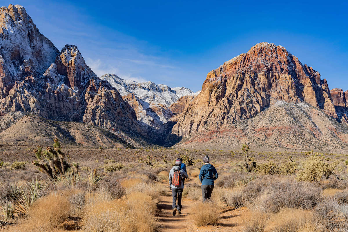
Many visitors to Las Vegas are surprised to learn that it’s not all casinos and nightlife. The city also offers stunning hiking trails in places like Red Rock Canyon, Mt. Charleston, and Valley of Fire State Park. Most of these outdoor gems are located within an hour’s drive or less of the Strip and are home to some of the best hikes in Las Vegas.
Having lived in Vegas for over 10 years myself, I have thoroughly explored the Las Vegas hiking scene. There are trails for everyone whether you’re looking for a challenging hike or a leisurely stroll.
In this blog post, I give you the rundown of 6 of my favorite Las Vegas hikes that offer breathtaking views and an opportunity to connect with nature in the desert oasis of Las Vegas.
Looking for more adventurous things to do in Las Vegas? Check out our post on the best outdoor adventures around Sin City.
This post may contain affiliate links.
1. Calico Tanks Trail
- Trail type: Out-and-back
- Location: Red Rock Canyon
- Distance: 2.3 miles
- Elevation Gain: 420 ft
- Time: 2-3 hours
- Difficulty: Moderate, some scrambling required
- Dogs allowed?: On leash
- Fees: $20 entrance fee or free with an America the Beautiful Pass
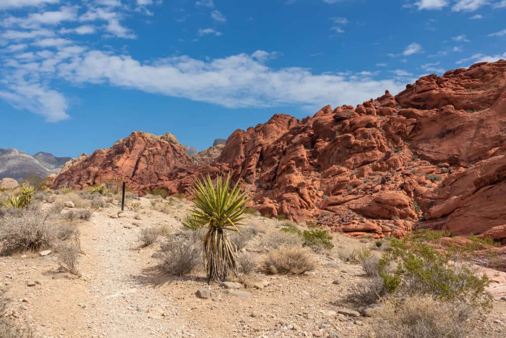
One of the first trails I ever hiked when I moved to Las Vegas was the Calico Tanks Trail in Red Rock Canyon. I was blown away by the stunning views of the red rock formations and the hidden natural pools of water, known as Calico Tanks.
It’s also a great hiking trail to get close-up views of Las Vegas’s unique desert plants and cacti. You may even spot some wildlife like rabbits or lizards!
The trail is a little tricky in places with some rocky sections that require careful footing. Be prepared to scramble with your hands at times. But the reward at the end is worth the effort. You can relax by the beautiful blue-green pool surrounded by towering rocks or continue past the pool for a panoramic view of the Las Vegas Valley.
This is one of the best hiking trails for out-of-towners because you get an epic view of the Strip at the end.
Important: Between October 1st and May 31st, a Timed Entry Reservation into Red Rock Canyon National Conservation Area is required between 8am and 5pm. You can make your Timed Entry Reservation online.
Save this post!
Enter your email & I'll send this post to your inbox! You'll also receive my weekly newsletter full of helpful advice for planning your adventures.
2. Mary Jane Falls Trail [CURRENTLY CLOSED]
- Trail type: Out-and-back
- Location: Mt. Charleston
- Distance: 3.3 miles
- Elevation Gain: 1,036 ft
- Time: 2-3 hours
- Difficulty: Moderate
- Dogs allowed?: On leash
- Fees: None
NOTE: As of November 2023, the Mary Jane Falls trail is currently closed due to storm damage.
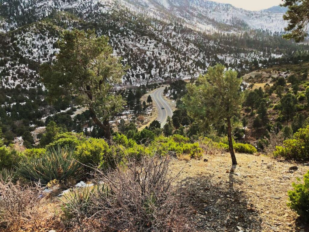
Mt. Charleston, located in the Spring Mountains National Recreation Area, is a place not many visitors to Las Vegas explore. In fact, most people don’t even realize that just a short drive away from the city is a nearly 12,000-foot peak!
My favorite Las Vegas hike on Mt. Charleston is the Mary Jane Falls Trail. It’s a challenging hike with over 1,000 feet of elevation gain, but it’s also very rewarding.
As you hike, the trail takes you through a scenic mountain canyon that is surrounded by tall aspen trees. After about 1.6 miles, you’ll reach a cliff face where, if you’re lucky, Mary Jane Falls will be trickling down from above.
The falls are usually covered in snow in the winter, but it’s a popular hike in the summer months since the temperatures are typically 20 degrees cooler than in the Las Vegas Valley.
Tip: If you want to see water cascading down Mary Jane Falls, it’s best to do this hike in late spring or early summer when the snow is melting off Mt. Charleston.
3. Historic Railroad Tunnel Trail
- Trail type: Out-and-back
- Location: Lake Mead National Recreation Area
- Distance: 8.2 miles
- Elevation Gain: 931 ft
- Time: 3-4 hours
- Difficulty: Easy/Moderate (depending on length)
- Dogs allowed?: On leash
- Fees: $15-$25 or free with an America the Beautiful Pass

One of the most unique hiking trails near Las Vegas is the Historic Railroad Tunnel Trail. It follows an old railroad bed that was once used to transport supplies to and from the Hoover Dam construction site.
The two main attractions for the Railroad Tunnel Trail are the stunning views out over Lake Mead and the five tunnels that the path travels through. Each tunnel is about 25 feet wide, 30 feet high, and stretches a whopping 300 feet long!
The Historic Railroad Tunnel Trail is a different experience than the other hikes on this list, but if you’re interested in history or engineering or want to catch some great views over Lake Mead, it’s a nice hike to add to your list.
The trail starts at Lake Mead National Recreation Area and since it’s an out-and-back, you can turn around whenever you’re ready.
Prefer to bike? The Railroad Tunnel Trail is also open to cyclists if you want to explore the full 8.2-mile path.
4. Ice Box Canyon Trail
- Trail type: Out-and-back
- Location: Red Rock Canyon
- Distance: 2.2 miles
- Elevation Gain: 439 ft
- Time: 1.5-2.5 hours
- Difficulty: Moderate with some light scrambling
- Dogs allowed?: On leash
- Fees: $20 entrance fee or free with an America the Beautiful Pass

For the more adventurous hikers, the Ice Box Canyon Trail is a great way to get away from the crowds and explore a lesser-visited part of Red Rock Canyon National Conservation Area.
This trail isn’t well marked, so you’ll need a map or GPS app like AllTrails to help you navigate. There is also some light scrambling required through boulder fields, so be sure to wear sturdy hiking boots and be prepared to use your hands.
But the rewards of this hike are worth it! The views through Ice Box Canyon are stunning with tall cliffs towering above you on either side – some sections even feel like narrow slot canyons.
There’s also a seasonal waterfall at the end of the trail. You’re most likely to catch water flowing between December and April.
Lastly, keep an eye out for Bighorn sheep, which like to traverse the canyon walls.
Want more ideas for how to spend a day in the park? Here’s a full list of things to do in Red Rocks.
Important: Between October 1st and May 31st, a Timed Entry Reservation into Red Rock Canyon National Conservation Area is required between 8am and 5pm. You can make your Timed Entry Reservation online.
5. Fire Wave Trail & Seven Wonders Loop
- Trail type: Loop
- Location: Valley of Fire State Park
- Distance: 1.9 miles
- Elevation Gain: 187 ft
- Time: 2-3 hours
- Difficulty: Moderate
- Dogs allowed?: On leash
- Fees: $10-$15 entrance fee

Every outdoor enthusiast who visits Las Vegas should spend at least a few hours exploring the incredible scenery at Valley of Fire State Park, northeast of the city.
Known for its famous red and pink Aztec sandstone formations, Native American petroglyphs, scenic drives, and stunning hiking trails, this state park is truly a gem.
My favorite hike in Valley of Fire is the Fire Wave Trail and Seven Wonders Loop. It is a very popular hike, so be prepared to share it with other people, but the terrain and geological wonders make it a must.
The trail can be done in either direction, but I like to hike it counterclockwise so I end on the Fire Wave Trail with its swirling red and pink sandstone slabs – I’d never seen anything like it before moving to Las Vegas!
Other highlights along the loop include Pink Canyon with its narrow walls and sandy bottom, the brilliant Fire Cave, and Thunderstorm Arch, which rivals any arch in Arches National Park. If you want to make it longer, you can also add on the 1.1-mile White Domes Trail, which also features a narrow slot canyon and unique white rock formations.
This loop is very exposed with little to no shade, so bring lots of sun protection and water in a day pack. I also highly recommend planning your hike for early in the morning or late in the afternoon to avoid the worst of the heat.
Important: Many of the hiking trails in Valley of Fire State Park – including Fire Wave and the Seven Wonders Loop – are closed between June 1st and September 30th due to extreme temperatures.
6. Arizona Hot Springs Trail
- Trail type: Loop
- Location: Lake Mead National Recreation Area
- Distance: 5.9 miles
- Elevation Gain: 1,225 ft.
- Time: 5-7 hours (+ soaking time)
- Difficulty: Very Strenuous
- Dogs allowed?: On leash
- Fees: $15-$25 or free with an America the Beautiful Pass

The Arizona Hot Springs Trail is an epic hike located about 30 minutes from Las Vegas on the Arizona side of Lake Mead National Recreation Area.
Also known as Ringbolt Hot Springs, it’s one of the best Las Vegas hikes for incredible scenery and unique features. From narrow slot canyons with towering walls, spectacular views out over Lake Mead and the Colorado River, and heated pools that you can sit and relax in, it’s a bucket list hike for many locals and visitors.
There are several different pools, all ranging in temperatures from cool to 100+ degrees.
There are a couple of things you should know before heading out on this trail, though:
- Don’t submerge your head in the hot springs. Amoeba can enter your nose and cause a life-threatening infection.
- Flash flooding can occur. Don’t attempt this hike during or after heavy rains.
- The trail is closed in the summer. People have died from heat exhaustion and dehydration. Do not try to sneak in during the summer months.
- Bring lots of water! You’ll also need to bring extra to sip on if you plan to spend time at the hot springs.
- Wear water shoes or sandals since much of the hike is in sandy or shallow water.
- People soak in the nude, so it’s not the best place to bring kids.
After you have finished soaking in the hot springs be sure to continue through the canyon until you reach the Colorado River, the views there are simply amazing!
If you prefer a different kind of adventure, you can also kayak to these hot springs and several more on the Colorado River. Check out BFT’s Guide to Kayaking Black Canyon’s Hot Sprigs from Hoover Dam.
Best Time of Year for Hiking in Las Vegas
The best time to hike in Las Vegas is during the cooler winter months between November and March. Daytime temps in the winter range from the mid-50s to low 70s, which is ideal for heading out on the trail.
The only anomaly is Mt. Charleston, which receives snowfall in the winter, making it a great place to go snowshoeing (get tips for snowshoeing here). Otherwise, Mt. Charleston is best visited in the summer months for hiking (and it is often 20 degrees cooler than the Valley!).
Summers in Las Vegas can be dangerously hot with temperatures soaring into the 100s. If you do plan on hiking during the summer, it is essential that you get a very early start (think: sunrise or earlier) and pack plenty of water and sun protection.
It’s also important to note that many Las Vegas hikes are closed during the summer including the Arizona Hot Springs, Railroad Trail, some trails in Valley of Fire State Park.
Tips for Hiking in Las Vegas
Before heading on your Las Vegas hikes, here are some essential hiking tips to keep in mind:
Bring a map
It’s easy to get lost in the desert as there aren’t always features that clearly define the trail. Before you head out, download the map to your phone using Gaia or AllTrails and make sure you have plenty of battery to last the day.
Pay attention to the trail as you hike. You might notice trail makers, otherwise known as cairns. These are typically built by land managers to help hikers know they are on track, which is why it’s important not to build your own rock stacks for fun in the wilderness.
Carry plenty of water and snacks
It’s important to stay hydrated and fueled while hiking in the Las Vegas desert. Make sure to bring at least 1-2 liters of water per hour of hiking. I highly recommend bringing a hydration backpack so you don’t have to rely on water bottles. The hot temperatures and sun exposure can quickly dehydrate you.
You’ll also want to pack energy-dense hiking snacks like nuts and energy bars to keep your energy levels up.
Lastly, don’t forget to bring a cooler with ice to store a post-hike beverage in your car!
Dress for the desert
If you’re not used to hiking in the desert, it’s a good idea to brush up on some of BFT’s desert hiking tips – especially regarding what to wear.
During the day, desert temps can be hot and dry, so you’ll want to wear breathable, lightweight, moisture-wicking fabrics in light colors. This will help you stay cool and comfortable on the trails. You might even want to consider a long-sleeve sun shirt to help protect your skin and keep the sun’s rays at bay.
In colder weather, wear moisture-wicking layers so you have options as the day warms up or cools down.
When it comes to footwear, opt for sturdy shoes or hiking boots that provide support, protection, and traction. The trails around Las Vegas can be rocky and loose, so you’ll need good traction and support.
Read More
Desert Hiking Resources
Inform someone of your hiking plans
Telling someone about your hiking plans is crucial for your safety. Share the details of what trail you plan on hiking, when you’ll be leaving, and when you expect to return.
This way, if anything goes wrong or you get lost, help can be sent to the right location. Hiking in the desert can be disorienting and even dangerous, so be sure to let someone know where you’re going.
Be cautious of wildlife and desert hazards
Hiking in the Las Vegas area comes with its fair share of wildlife and desert hazards, so it’s important to know what to expect and be cautious.
Don’t bust the crust
Cryptobiotic soil is a living crust on the ground surface that is comprised of microorganisms like cyanobacteria and other microbiota. These little black patches can be thousands of years old!
Cryptobiotic soil is important for a number of reasons including:
- Water absorption
- Preventing erosions
- New vegetative growth
If you see a thick, bumpy, black or brown crust, please make sure not to step on it. These tiny clumps are very fragile and important for the desert ecosystem.
READ NEXT
Looking for more outdoor adventures around Las Vegas? Check out these posts:
Save this post to Pinterest


What are your favorite hikes in Las Vegas? Which ones would you like to do? Leave a comment below!
Sadly, Mary Jane Falls doesn’t exist anymore. The trail was destroyed by the remnants of Hurricane Hilary.
Thanks for the heads up! That’s such a bummer. I’ll update the post.
You nailed the main ones Shannon. I lived in Vegas for 10 years while working for both the USFS and NPS. All your recommendations are good hikes for those that don’t want overnight adventures. For those taking you up – carry lots of water, heat stroke kills hikers every year.