Trail Guide: Franconia Ridge Loop in the White Mountains
Get ready to hike New Hampshire’s 8.5 mile Franconia Ridge Loop in the White Mountains with this detailed trail guide.

Up in scenic northern New Hampshire, there is a section of the White Mountains called Franconia Notch State Park. With miles of hiking, biking, and skiing trails, plus, lakes, rivers, and waterfalls (yeah, it’s all here) it is arguably one of the most varied and naturally beautiful parts of New England. I was lucky enough to grow up exploring the mountain ranges and gorges of the Franconia Notch State Park and I (along with its estimated 700 hikers per day) have totally fallen in love with the famous Franconia Ridge Loop Trail.
It’s a decisively strenuous and challenging hike that gives you extreme verticality in three peaks and some extremely stunning views. Hiking the ridge loop isn’t for the faint of heart, but it’s also not exclusively for experienced hikers. One of my favorite things about this hike is that it is truly a labor of love and doable for cautious and prepared hikers of all levels. All you need is a little determination and willpower — oh, and snacks, definitely bring the snacks.
Ready to get out there? Here is your complete guide to hiking the Franconia Ridge Loop Trail.
This post may contain affiliate links.
Franconia Ridge Loop Details
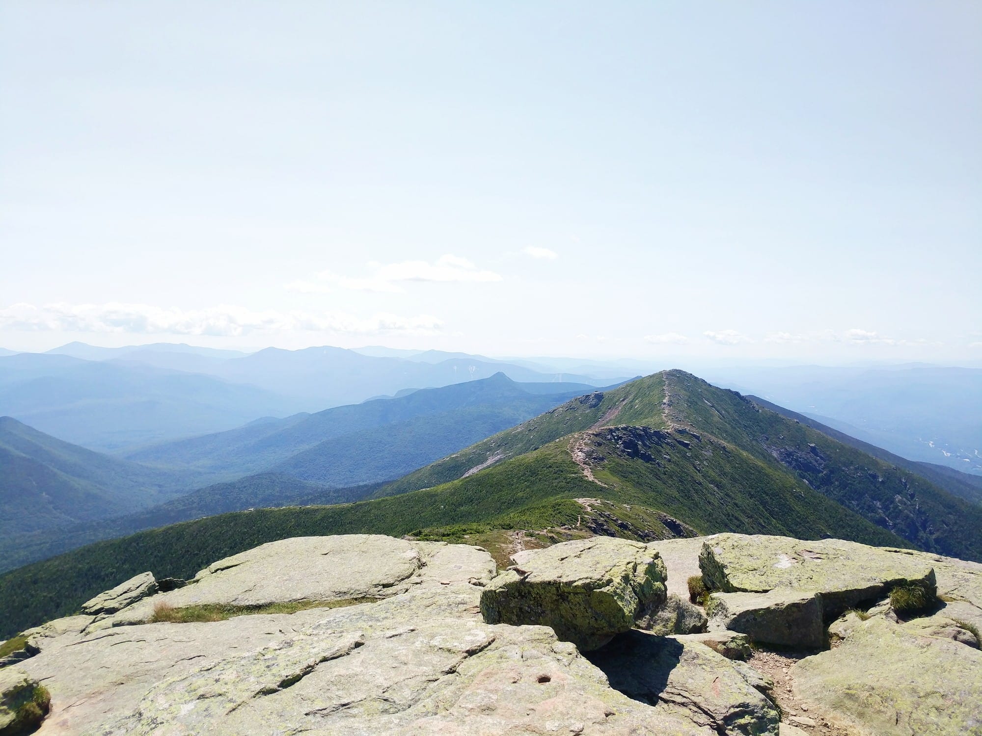
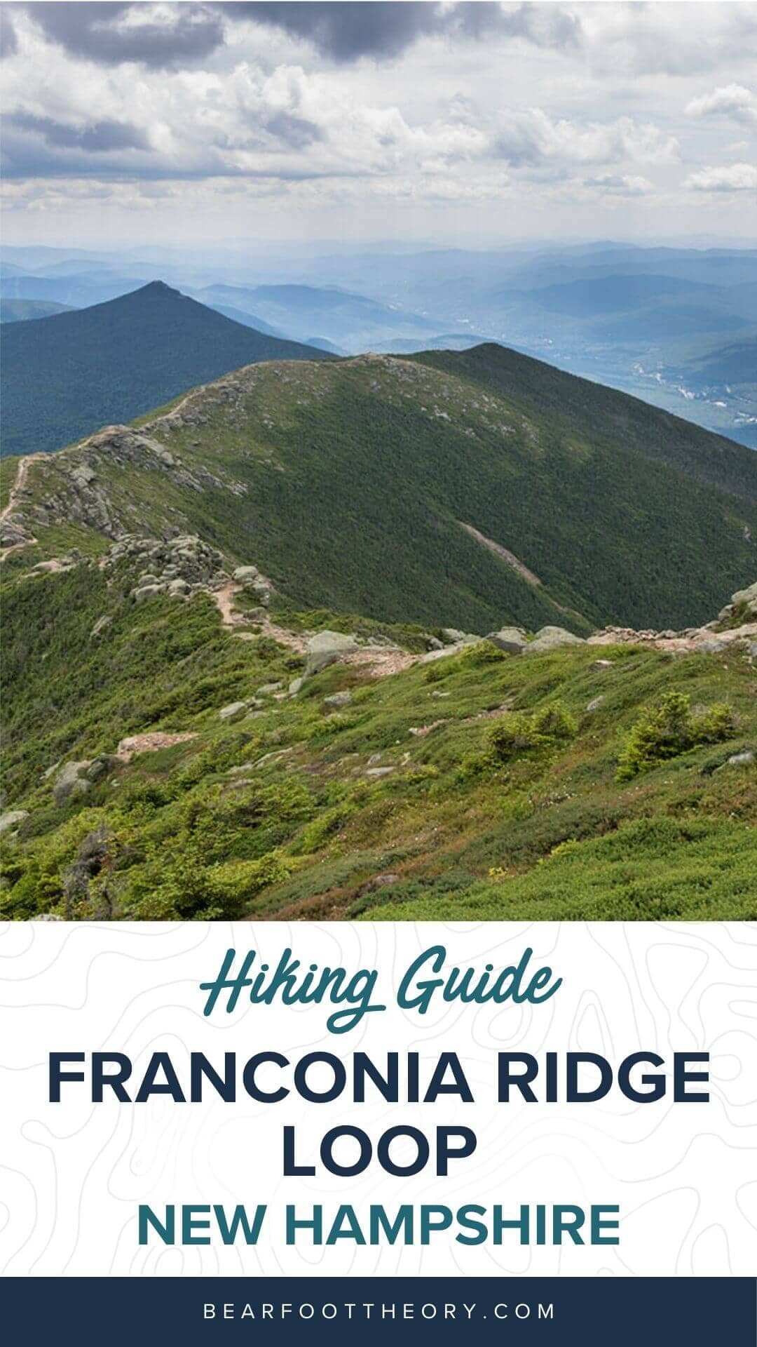
The Franconia Ridge Loop traverses Mount Lafayette, Mount Lincoln, and Little Haystack (4,780’) on Franconia Ridge, the second-highest range of peaks in the White Mountains. Since you are exposed on the alpine ridgeline for approximately a mile and a half, the weather can be extreme and change rapidly, so, check the Mount Washington Observatory website before you head out.
- Trail type: Loop
- Distance: 8.5 miles
- Difficulty: Strenuous
- Dogs allowed?: Yes
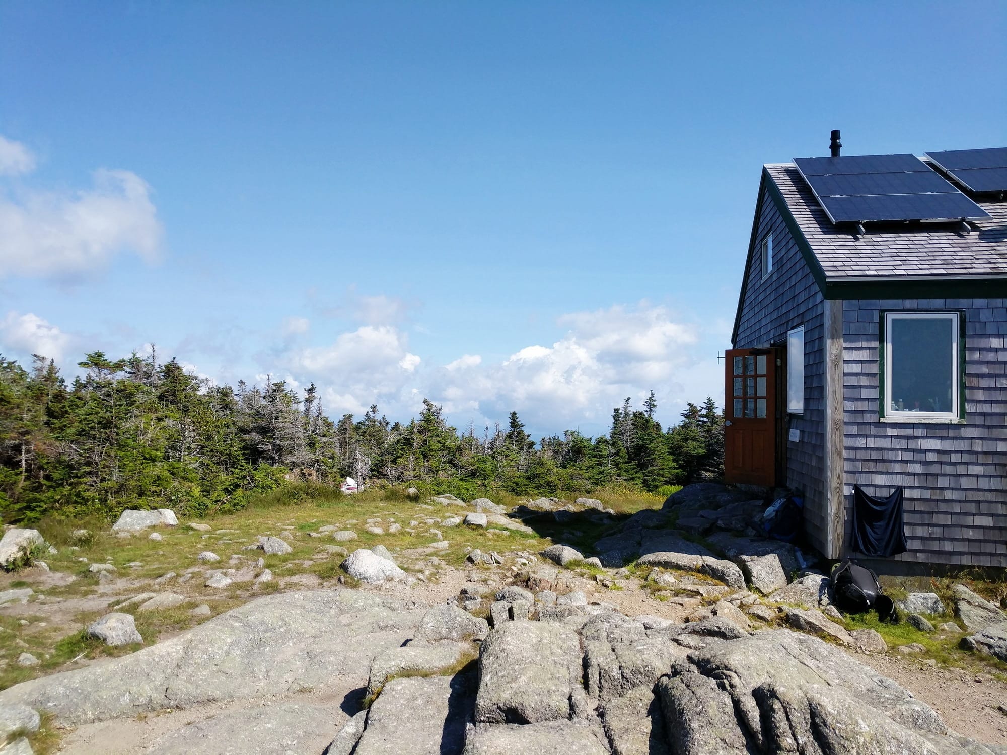
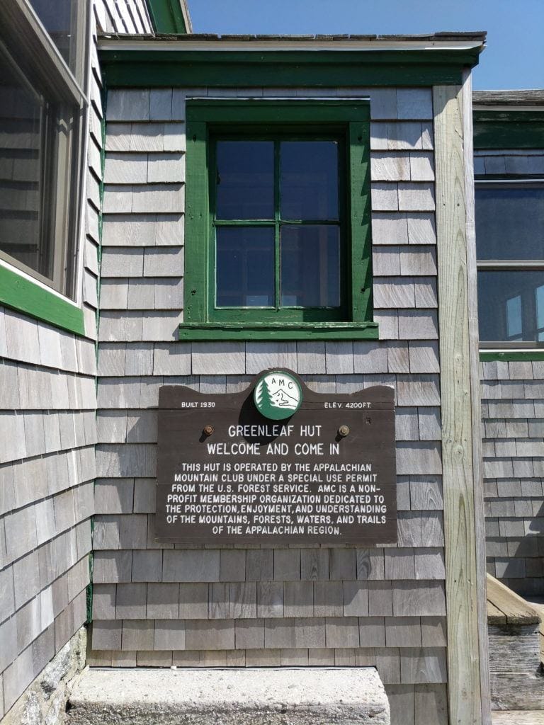
The ridge loop can be hiked within a day, but you can also stay at the Greenleaf Hut if you want to experience the Appalachian Mountain Club’s famous full-service huts and spend the night. Just make sure to check the huts availability and book your stay. Also, although the trail is dog-friendly, the huts are not. So, leave your pooch at home.
You must carry in and carry out all trash and recycling. Please remember to stay on the trail and leave no trace. The alpine flora and fauna are very fragile. Staying on the trail will prevent damage to this delicate environment.

Save this post!
Enter your email & I'll send this post to your inbox! You'll also receive my weekly newsletter full of helpful advice for planning your adventures.
Best Time to Hike the Franconia Ridge Loop
Although you can do the hike any time of the year, the best time to hike the Franconia Ridge Loop is from late May to September. You’ll have warmer temperatures and a better chance of clear skies during these months. Go mid-week to avoid the crowds and start hiking early on — this is easily a 7-10 hour hike and you don’t want to risk losing daylight. Since it is a very weather-dependent area, conditions can change drastically and instantly. Be prepared for all types of weather before heading out and be sure to pack a rain jacket, warm layers, and a headlamp in case you end up hiking in the dark.
How to Get to The Franconia Ridge Loop Trailhead
The entirety of Franconia Notch State Park is easily accessible by Route 93 North and South, a highway that runs between the two mountain passes of Kinsman and Franconia Range. No matter which direction you are coming from, it’s a really scenic drive to the trailhead, with mountain ranges flanking you on both sides as you cruise along.
To get there, park at the Lafayette Place parking area where you will see a well-marked trailhead on the east side of the road. This is a popular trail so you won’t be able to miss the many cars and hikers who are most likely to be here, too.
Franconia Ridge Loop Trail Hiking Guide
The first and most important thing to know is that there are two different ways to hike up to the ridge — a polarizing issue among many seasoned hikers. The most popular way up is the Falling Waters Trail that leads you past a waterfall and up a steep, rocky path to Little Haystack.
However, I prefer to take the Old Bridle Path all the way up to the steepest of the three peaks, Mount Lafayette, because it typically is less crowded and offers scenic vistas where you can stop and rest on your climb up to the summit. Whichever way you decide to go, you’ll certainly run into some steeps but the Old Bridle Path, although is the steepest ascent, brings you the best rewards, less foot traffic, and a slightly easier way down.
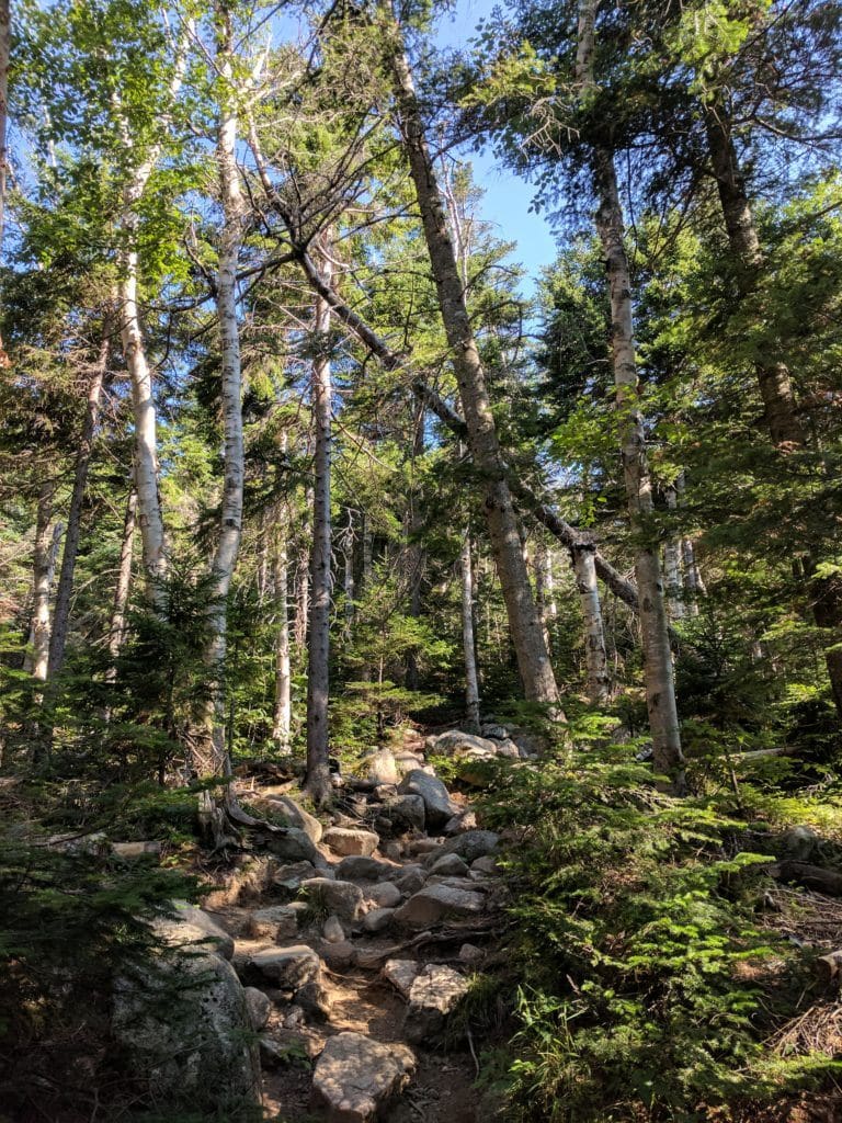
From the parking lot, take the Old Bridle Path for three miles, where you will climb up a strenuous section of the trail known as Agony Ridge, bringing you a 3,480 foot gain in elevation.
The effort really pays off in the form of stunning views and a glimpse of the summit that can’t be seen from the road. What’s more is that Agony Ridge takes you to the AMC Greenleaf Hut, which sits just above the treeline, overlooking Eagle Lake.
If you are there between the months of June and October, you’ll be able to score some water, a homemade snack and meet the fun and dedicated “Hut Croo” who care for this cozy alpine lodge. During my last hike, the cook had just made fresh gingerbread which I thoroughly enjoyed while we chatted with a few other hikers who were passing through. It was the perfect stop before heading up the long and bouldery mile-long trek to the summit.

During your final haul up to the first peak make sure that you follow the blazes up the mountain and stay on the marked trail. It’s easy to lose your direction and zigzag through the boulder field, but in doing so you’re likely to trample the fragile alpine plants, so, tread lightly.
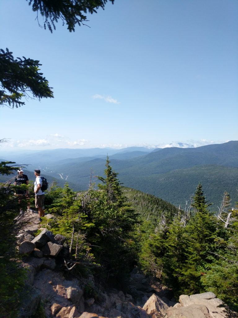
When you finally get up to the top of Mount Lafayette, take your time enjoying the panoramic view of the Pemigewasset Wilderness Area. From here, you can look south to the next two peaks along the ridgeline that more closely resemble the Alps than the White Mountains.

After Mount Lafayette, the elevation begins to get a little lower and you’ll continue along a well-worn path to the summit of Mount Lincoln and Little Haystack. Once you’ve bagged your third and final peak (go you!) keep an eye out for the blue trail blazes that will lead you back down to the Falling Water Trail.
An initially steep descent, the Falling Water Trail starts to level out after a couple of miles and leads you below the treeline to the 80-foot Cloudland Falls where you can cool off and rest your feet. From here, continue to follow the Falling Water Trail all the way back to the parking lot to complete your 8.5-mile loop.
Have you hiked the Franconia Ridge Loop in New Hampshire or are you planning to? Leave your comments and questions below!
One thought is its’ great you are writing about hikes on the east coast.
But I am disappointed that you chose this hike — why because its Mall of the Americas — on any given weekend you can find hundreds of hikers jostling for the trail. Loads of folks in sneakers and tshirts, not a clue what they are doing. This is one of the very few trails where the NFS Park Ranger or a volunteer will ask you questions before you go up, in hopes of sorting out unprepared idiots. You’d have to ask Pemi SAR, but I bet the loop is the most popular trails for rescues.
Next, there is now very limited parking, as the NH state police are cracking down on parking on Rt 93 so parking can be a challenge.
I could go on and on about what other mts to hike in the Whites. If you need ideas on great hikes the 4K FB group is filled with smarter people than I.
Cheers,
D
Thanks, Dennis. We are going to be continuing to grow the list of hikes in the White Mountains that we feature. A large focus of our blog is also helping to prepare hikers for the elements and trails. Hope to see you out there!
As always to garner maximum optimal enjoyment I truly enjoy planning out a hike at least five weeks in advance by mapping out the actual hiking trail map routing to be taken on the day of planned hike by using:
alltrails.com
they have an excellent free hiking trail map routing tool that enables one to zoom in on the actual hiking trail map routing down to the 200 foot elevation level in order to allow one to actually see all of the really minute graphic details that can be observed, outlined and documented in the form of ones own official personal documented notes to be jotted down and typed up for potential useful reference for the “day of planned hike”; I do that extra level of documented planning detail to help document where I actually took a particular set of interesting inspiring creative beautiful photographs; so that in the future if I go back I can potentially get more of those same kinds of beautiful interesting stock photographs.
Hey Daniel, thanks for reading and I appreciate you taking the time to share that advice. Agreed that the best way to do popular hikes, like the Franconia Ridge Loop, is by being prepared and scoping things out in advance to avoid any hassles. We are big fans of All Trails, too! Such a useful resource for getting great photos, plus some reviews from recent hikers that will help you get your plans dialed.
Thanks again!
K
Hello,
I am planning on Hiking the Franconia Ridge Loop, in a few weeks.
I am giving myself 10 hours to do this Trail.
Thing is, I will be driving 4 hours to get to the Trail. then 4 hours back to get home!
I am hoping to keep a 1.3 to a 1.6 mile per hours average pace.
I’m just not sure on how tough the Falling Waters Trail is?
To me, that seems like the most difficult part of the Loop?
I have been up to the Top of MT, Monadnock twice, using the White Dot & White Arrow Trails.
Just curious how similar the Loop Trails would be to those?
Thanks!
Hey John,
You’re definitely doing it right by giving yourself plenty of time; 10 hours at that pace will be more than enough. It’s a challenging trail that’s steep and very bouldery, so it’s a good idea to build in rest time. Keep in mind the parking is slim, so the earlier of a start you get the better, and try to go midweek to beat the crowds!
Have fun and thanks for reading!
Katherine
Hi,
Where did you stay after doing this hike? I am planning a trip to NH and Maine (using your other blog posts) with my husband and my dog and we are trying to figure out where to stay to do the hiking in the White Mountains. Any advice is appreciated!
Hi! Katherine, who wrote this post, actually lives in the area so we don’t have any first hand recommendations on where to stay. Sorry we can’t be of more help there, we hope you have a wonderful trip!
Hi, thank you for this resource! I hiked Franconia Ridge Loop once, a few years back, and for me, it was my favorite hike on the east coast. It just had everything that I was looking for in a hike. We also tried to go at a time when it might not be too crowded, which is how it worked out. We also started very early in the morning. I am planning to hike Franconia again within a month or two.
Remember, Life is supposed to be fun!
Gregg
Hi Gregg, it’s also one of our favorite east coast hikes! Sounds like you timed it right to have some serenity – enjoy your next adventure out there & love your life motto.
This was indeed a great hike! However, after the fact, and as one of those “unprepared idiots” mentioned by the first commenter, I think I agree with him. My wife and I took almost ten hours to do this loop, albeit including an hour break for lunch in the cabin. We’re youngish and fit-ish, and had enough water and food, but we ended up back in the parking lot close to sundown, without having packed headlamps or blankets. So just keep in mind if you are a relatively inexperienced hiker (we have done Mt. Monadnock and Sete Cidades among others, but it’s hardly our main hobby), 7 hours is a vast underestimate for this loop!
Hi Jason, thanks for sharing your experience! I just edited this to include a wider range of hiking time and a note to pack a headlamp.
Your photos of the Franconia Ridge Loop are stunning. My husband and I did this loop last July. This past June I did a solo of the Presidential Traverse and unfortunately had super bad weather. Every peak was socked in. I feel like coming back to the White Mountains just to get good photos.
Hi Diane, thank you! The Whites are truly stunning. Great job on tackling the Presidential Traverse solo, but bummer about the weather. It does sound like a return trip is in order 🙂
We have a few other blog posts about hiking there in case you need other hiking inspo:
https://bearfoottheory.com/waterfall-hikes-white-mountains-new-hampshire/
https://bearfoottheory.com/best-new-hampshire-hikes/
Thank you for all the great information! Heading out there soon. Guessing it will be raining and snow but I’m going for it anyway because I’m only in town a short amount of time.
Have a great trip and be safe!