7 Best Telluride Hikes for Lakes, Waterfalls, & Views
Learn about 7 of the best Telluride hikes including distance, elevation gain, and directions to the trailheads.
Known for snowy slopes, great food, and a happening arts and music scene, the Telluride hiking trails are also world-class. Step out your door and see 14,000-foot tall mountains towering over town (including Wilson Peak, the mountain best known from the iconic Coors logo), and alpine lakes hidden just out of view.
Within a short drive of town, you will discover Lizard Head Pass at 10,000 feet, with wildflower-filled meadows and trailheads leading into the backcountry. Head the other direction toward the Dallas Divide and catch one of the most spectacular views in the country, without even leaving your car.
Read on to discover the best Telluride hikes for lakes, waterfalls, and epic views.
This post may contain affiliate links.
Map of the Best Telluride Hikes
Save this post!
Enter your email & I'll send this post to your inbox! You'll also receive my weekly newsletter full of helpful advice for planning your adventures.
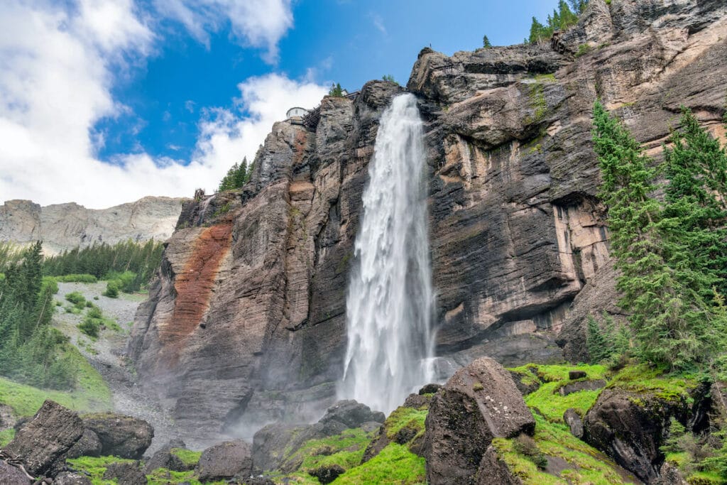
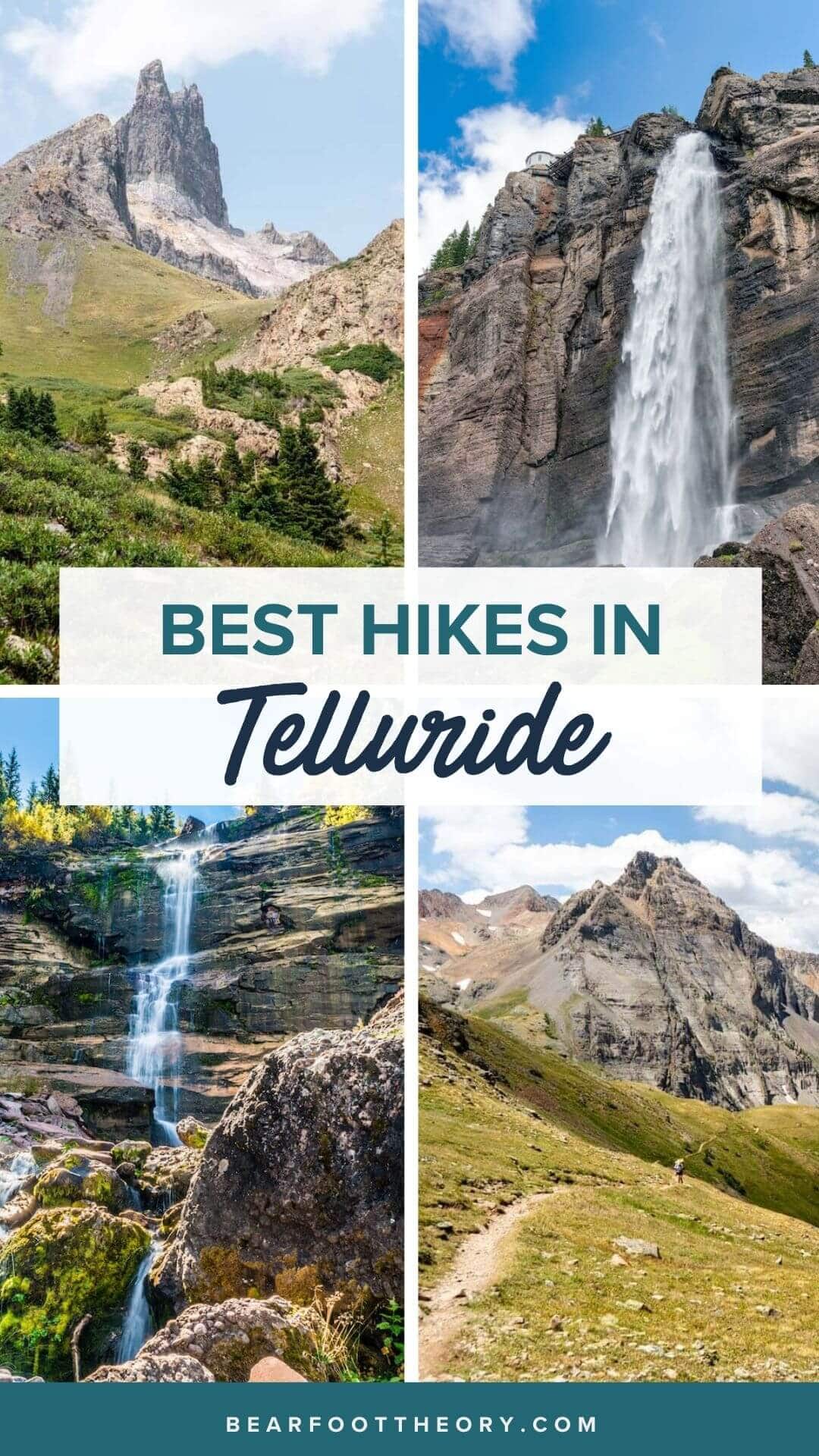
1. Bridal Veil Falls
- Distance: 2.5 miles round trip to the bottom of the falls or 3.4 miles round trip to the top of the falls
- Elevation Gain: 850 feet to the bottom of the falls, 1600 feet to the top of the falls
- Difficulty: Easy/Moderate
- Trail Type: Out and Back
- Dogs Allowed: Yes
Bridal Veil Falls tumbles 365 feet down a sheer cliff, making it the tallest free-falling waterfall in Colorado. The hike can be done two different ways, either on a trail or on a jeep road. When I did this hike, we hiked up the trail and took the road down. This stunning Telluride waterfall is definitely worth the trip.
The trail meanders through boulders and trees, climbing above the town. Make sure to stay on the trail at all times, as much of the surrounding property is private. Take in the views down and across the valley as you climb higher and higher towards the waterfall. When you arrive at the waterfall, marvel at the cascading spray and beautiful views. Look out for the power plant above the waterfall, which supplies hydroelectric power to the town of Telluride. If you choose to drive or hike to the top of the falls, you could then continue on to Blue Lake, Silver Lake, or Mud Lake.
Getting There: From Downtown Telluride, continue down Colorado Ave (the main street through town) for about 1.5 miles. You will pass a mine and find a parking area at the end of the road. When we were there, we had to park on the road by the mine since the parking area was full. This is a popular area! Get there early to secure parking. If you drive a 4WD, high clearance vehicle, you can continue up the road to find additional parking or drive to the top of the falls.
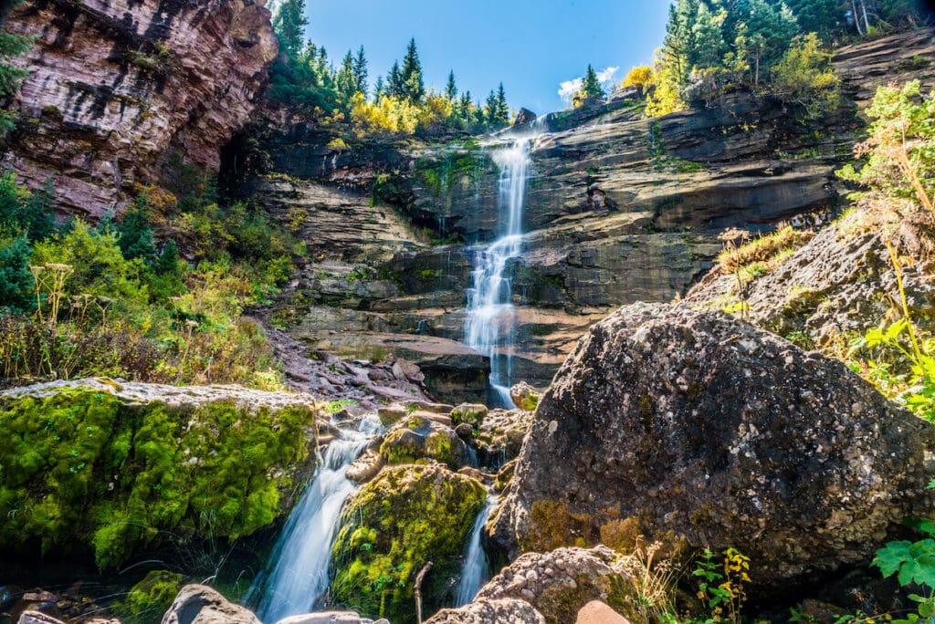
2. Bear Creek Trail
- Distance: 5 miles round trip
- Elevation Gain: 1,100 feet
- Difficulty: Moderate
- Trail Type: Out and Back (or combine with Wasatch Trail and See Forever for a long loop!)
- Dogs Allowed: Yes
Hike an old forest road from right in town up to the beautiful Bear Creek Falls on one of the best hikes in Telluride. This popular trail is never too steep, gaining elevation gradually over a couple of miles. There are two waterfalls on this trail, upper and lower Bear Creek Falls.
You will reach the first fall in about 2 miles of hiking on the old road. Continue further to the junction with the Wasatch Trail, where you could continue on the right fork if you are looking for a longer trip (and some pretty epic views). Stay straight to reach the upper Bear Creek Falls. On the way back, enjoy views of the surrounding peaks, cliffs, and the town of Telluride at the end of the canyon!
Getting There: This trail starts at the end of South Pine Street in Telluride. Turn right off of Colorado Ave onto Pine Street and drive or walk four blocks to where it turns into a wide dirt trail. This trail is also popular with mountain bikers and horseback riders, so make sure to share the trail!
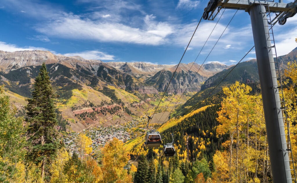
3. See Forever Trail
- Distance: 5.5 miles round trip
- Elevation Gain: 1,700 feet
- Difficulty: Easy/Moderate
- Trail Type: Out and Back (or combine with Wasatch trail and Bear Creek for a loop!)
- Dogs Allowed: Yes
Another great hike right in Telluride, Colorado, the See Forever Trail ascends through the ski resort to give summer views of these popular winter slopes. The trail is wide and well-graded since they are ski trails and access roads. This would be a great hike for a family or anyone who just wants to take a walk to see the views above the town. And the views make it well worth the elevation gain. 360-degree mountains and valleys surround you, from the Lizard Head Wilderness to the west to the Sneffels range rising east of Telluride.
At about 2.8 miles, the See Forever trail intersects the Wasatch connector trail. Here you can turn around and head down, or continue on to the Wasatch trail to intersect the Bear Creek trail to make an 8.5 mile loop back to town.
Getting There: To get to the See Forever trail, you have to take a gondola. You can either park in Telluride and take the gondola up to the St. Sophia station where the trail starts, or park in Mountain Village and take the gondola towards Telluride, getting off at the St. Sophia station.
4. Sneffels Highline Trail
- Distance: 12.5 miles round trip
- Elevation Gain: 3,380 feet
- Difficulty: Challenging
- Trail Type: Loop
- Dogs Allowed: Yes
The Sneffels Highline trail is a difficult and scenic hike that consists of alpine meadows, forests, and views for days! If you have all day, want to traverse beneath towering peaks, and take in the Telluride scenery, the Sneffels Highline trail is a must-do hike. The trail reaches 12,000+ feet, on a saddle below the breathtaking Mount Emma, so if you are from a low elevation area, make sure you are acclimatized before attempting this strenuous hike. With the elevation gain, be sure to pack trekking poles for this hike.
This hike connects multiple trails starting on the Jud Weibe trail from right in downtown Telluride. Then after about half a mile, turn left on the Deep Creek trail. Continue until you reach the Sneffels Highline trail, and then you can choose which direction you want to do the loop. Going right (recommended) on the Highline trail brings you to the high point first with a steeper climb, while going left on the Deep Creek trail is a gradual, but much longer climb. The hike remains above treeline for the majority, and will eventually descend into the Mill Creek basin.
Getting There: The trail starts on the Jud Weibe trail which can be found at the end of Aspen Street in downtown Telluride. From Colorado Ave (main street), turn left on Aspen and proceed to the end of the road. Parking at the trailhead is by permit only, and the parking along Colorado Ave has a 2-hour limit. The free Galloping Goose shuttle bus runs between two free parking lots in town and several stops throughout town.
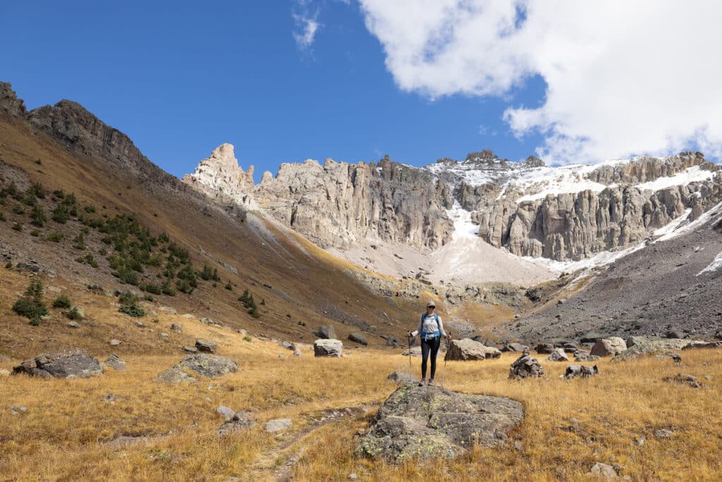
5. Hope Lake
- Distance: 5 miles round trip
- Elevation Gain: 1,130 feet
- Difficulty: Easy/Moderate
- Trail Type: Out and Back
- Dogs Allowed: Yes
The Hope Lake trail traverses through the gorgeous San Miguel Basin to a beautiful alpine lake. This is one of the best lakes near Telluride for hiking and exploring. This trail is an easy-moderate way to explore the alpine, as the first mile or so is not very steep. Make sure not to miss the unmarked creek crossing at .4 miles, or you will end up on the trail up Poverty Gulch instead of heading to Hope Lake. The last bit to the lake consists of switchbacks, topping out to spectacular views of the Wilson range, Lizard Head, San Miguel Peak, and Vermillion Peak.
If you have the energy to continue after reaching the lake, the trail keeps going up to Unnamed Pass to add another mile or so on to the hike. If you are hiking in the summer months, stop and enjoy the wildflowers along the trail!
Getting There: To get to the Hope Lake trail, head south out of Telluride on Highway 145. Turn left at the turn for Trout Lake and follow the road around the lake (a great place to hang out after hiking) for about 2.5 miles until you reach Forest Road #627. Turn left and follow the road as it switchbacks up to the parking lot. The road can require some clearance but should be doable for most vehicles.
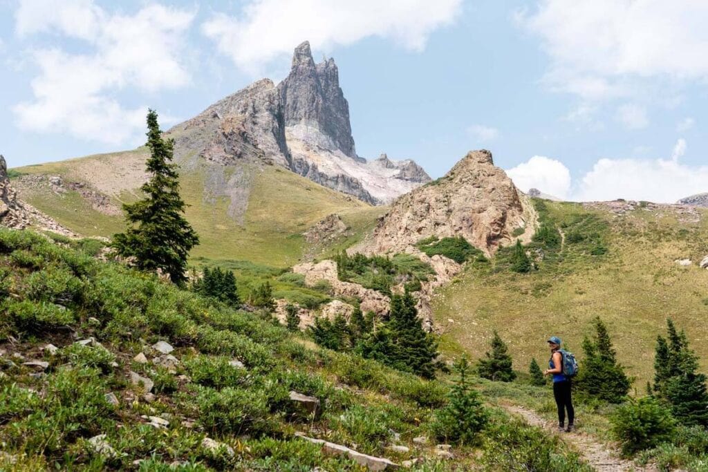
6. Lizard Head Loop
- Distance: 12 miles round trip
- Elevation Gain: 2,700 feet
- Difficulty: Challenging
- Trail Type: Loop or out and back
- Dogs Allowed: Yes
Lizard Head Peak stands tall over Lizard Head Pass, a strange rocky protrusion surrounded by fourteen thousand foot peaks and grassy meadows. This loop hike can be done in several sections, or as a spectacular loop.
When I hiked this loop, we started in the northern Lizard Head pass trailhead parking lot, and hiked counter clockwise. This got most of the climbing in the trees out of the way first, and left the views for the second half of the hike. The first part of the trail switchbacks through the forest with a few quick sneak peeks at the upcoming views. After emerging from the trees to grassy tundra, you will find yourself at the top of Black Face Peak, a 12,000 foot tall mountain overlooking the road a thousand feet below.
The trail then descends to a saddle before rising again to the base of Lizard Head itself. From here it is all downhill back to the road, where you can take a left on a dirt road that parallels the main highway to avoid having to walk along the road back to the car. Or, park a car at the southern trailhead to cut off the last mile or so of flat walking across the pass.
Getting There: From Telluride, head south on Highway 145 for about 12 miles until you reach Lizard Head Pass at 10,000 feet. Park in the first rest area/trailhead parking lot you reach, on the right side of the road. There is a restroom at the trailhead. The trailhead is on the north side of the parking lot.
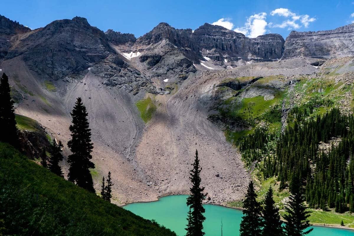
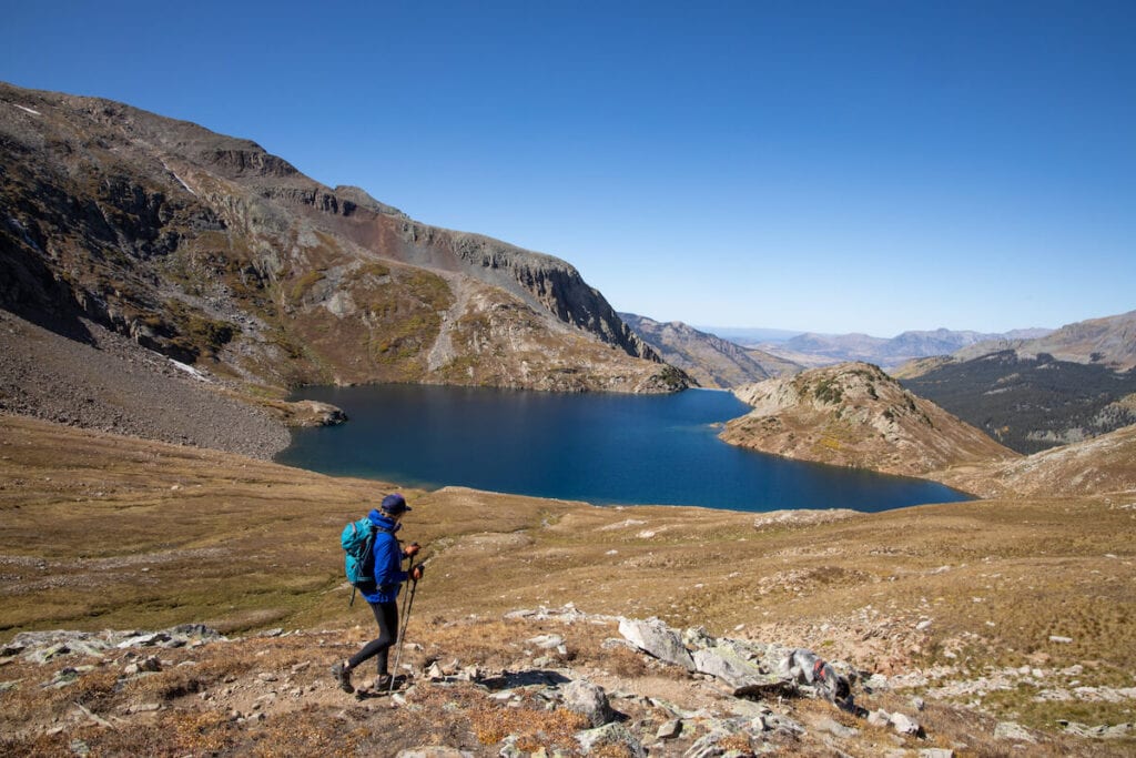
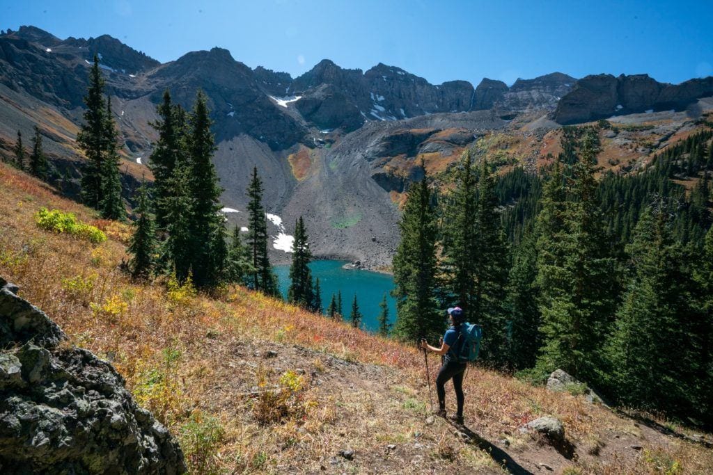
7. Blue Lakes Trail
- Distance: 10 miles round trip to all three lakes
- Elevation Gain: 2,600
- Difficulty: Challenging
- Trail Type: Out and back
- Dogs Allowed: Yes
Not to be confused with the Blue Lake above Bridal Veil Falls, the Blue Lakes hike visits three beautiful alpine lakes in the Mount Sneffels Wilderness. The hike winds its way through the forest following a creek up to three stunningly blue lakes below the fourteen thousand foot tall Mount Sneffels.
The first lake is a great place to hang out and have lunch before deciding whether or not to head to the other two lakes. If you choose to continue, the climb heads up steep and somewhat loose switchbacks to the other two gorgeous lakes. After that, you could head up more switchbacks to the top of Blue Lake pass to look down into Yankee Boy Basin on the other side, but it will add another couple miles on to the round trip. If you are brave, dive into one of the lakes to enjoy a shocking and refreshing dip in the bright blue water!
Getting There: Head west out of Telluride on 145 until you reach the junction past Placerville. Turn right on highway 62 toward Ridgway. Drive about 18 miles and then turn right onto County Road 7, also marked as East Dallas Creek road. After about two miles, stay right at a junction. Continue about 7 more miles until you reach a large parking lot with the trailhead. The road is good for most vehicles.
Have you hiked any of these Telluride trails? Are you planning a trip to Telluride? Let us know in the comments below!
This is a great resource, thank you! Is it available as a PDF?
Hi there! I’m planning a trip out there for a photoshoot and was hoping to get in as much hiking as possible while there. My 75 yr old mom and small dog are coming with me. We’ll be there on Aug 1st and 2nd. Do you have any advice on an easy but beautiful location with the mountains in the background for my photoshoot of a high school senior girl? I’ve never been.
You could drive down towards Rico. There are some nice places to pull off there that don’t require hiking to