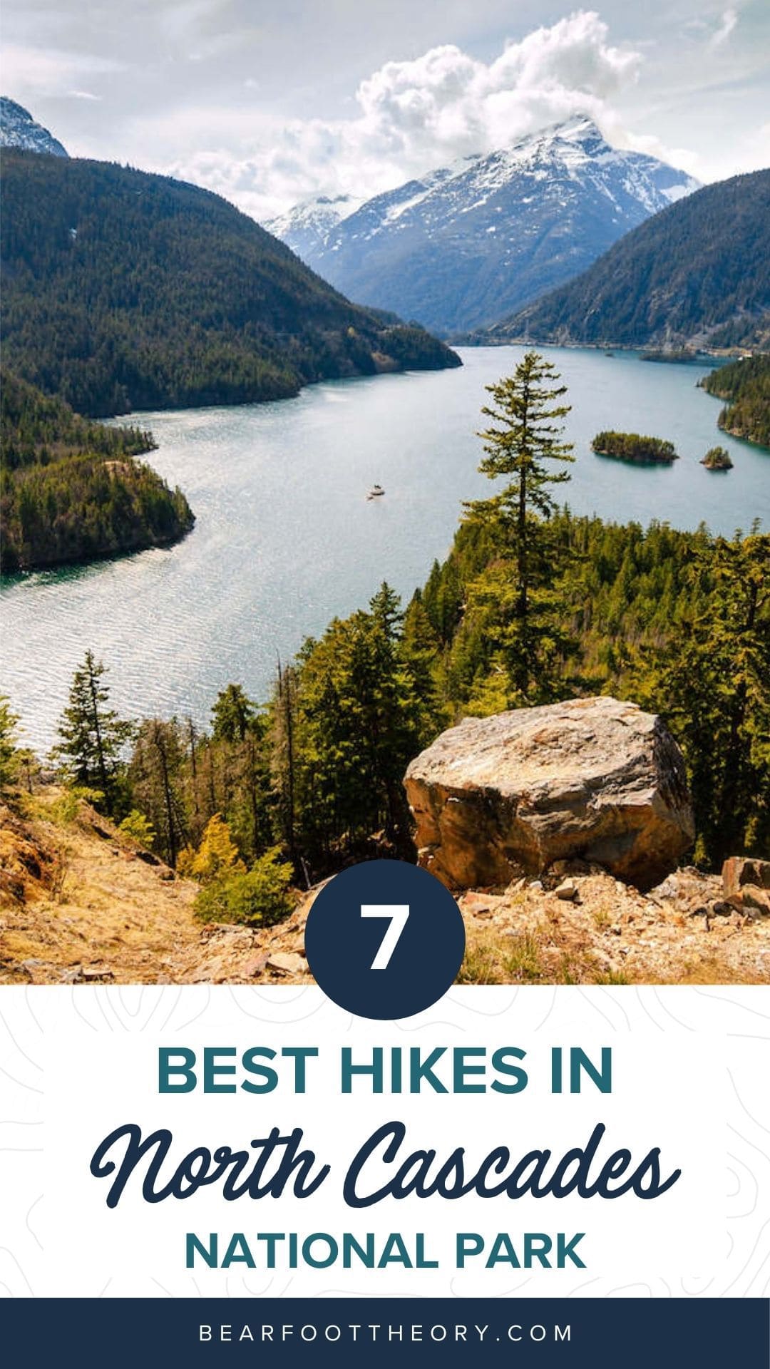
7 Best Hikes in North Cascades National Park
Discover the best hikes in North Cascades National Park for stunning mountain views, old-growth forest, clear alpines lakes, and more!
North Cascades National Park in Washington encompasses some of the wildest, most rugged backcountry in the lower 48 states. Visitors will find towering, glaciated peaks, deep river valleys, ancient cathedral forests, and sparkling gem-like alpine lakes. The best hikes in North Cascades allow you experience all this and more.
The entire park complex includes the National Park itself at the heart of the jagged North Cascades range as well as a pair of National Recreation Areas (NRAs): Lake Chelan NRA to the east and Ross Lake NRA to the west. The region also stands as one of the last areas where all the pre-Columbian wildlife species are still present, though some in frighteningly low numbers. From woodland caribou to grizzly bears, rare species are maintaining a toehold in the North Cascades.
Because of the remoteness of much of the Park’s lands, many of the trails are best suited for multi-day backpacking adventures, but there are some fantastic day hiking treks to be found and we’ve outlined the best of those here. Be sure to also check out our North Cascades National Park guide which has camping/lodging information, the best time of year to visit, and other activities you can do in the park.
Discover the best hikes in North Cascades National Park that showcase stunning mountain views, evergreen forests, clear lakes, and more.
North Cascade Hiking Permit Information
Within the North Cascades National Park Complex, there is no entry free nor permit requirements at trailheads. But many hiking trails into the park begin on U.S. Forest Service lands, and for those trailheads, a Federal Lands Pass is required.
A Northwest Forest Pass is available for $5 per day or $30 annually. The Annual Pass is valid at all National Forests in Washington and Oregon. Another option is to purchase an annual America the Beautiful Pass for $80, which can be used nationwide at federal recreational lands including USFS lands, National Parks, U.S. Bureau of Land Management (BLM) lands, and U.S. Fish and Wildlife lands.
North Cascades Hikes – Mapped
Best Day Hikes in North Cascades National Park
1. Thornton Lakes Trail
- Round-trip distance: 10.4 miles
- Elevation Gain: 2,400 feet
- Difficulty: Moderate-Difficult
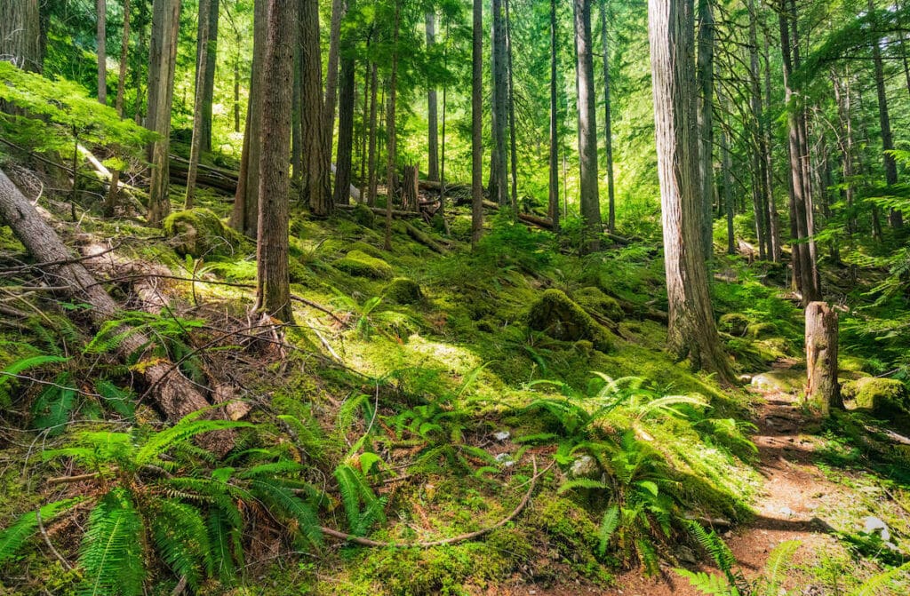
This trail starts with a history lesson. The first 2 miles or so follow an old railroad route through lush second-growth forest. The rail line was built specifically to haul logs out the woods in the 1950s and 60s, well before the national park was created. The trail here climbs gradually for hikers but would have been a good haul for trains.
The loggers took out most of the big old-growth trees, but in the 50-plus years since that harvest, the forest has regrown and filled in. A few big, old Douglas firs and cedars remain and between the giant trees, you’ll find a grand mix of big leaf maples, alders, young Douglas firs, hemlock, and silver fir.
After 2.5 miles of rambling through the valley, the trail starts to climb, winding through steep switchbacks to the National Park boundary at about mile 4. A half-mile further on, the path enters a broad meadow leading to the ridge crest. Enjoy grand views of the North Cascade peaks spread out before you: Mount Triumph, Trappers Peak, Teebone Ridge, and more.
The trail drops from the ridge saddle and after a steep half-mile descent it reaches the banks of Lower Thornton Lake. Boot paths (i.e., unofficial trails) lead upward from the lower lake to the other two Thornton Lakes in small cirques above.
NOTE: Camping is allowed in the Lakes area, but a backcountry camping permit is required. Details can be found on the National Park website.
Directions to the trailhead:
To get there, from the Puget Sound region, drive east on State Route 20 to Marblemount and continue for about 11 miles. Turn left onto Thornton Lakes Road and continue 5 miles to the trailhead. This gravel road is rough and not recommended for low-clearance vehicles or trailers.
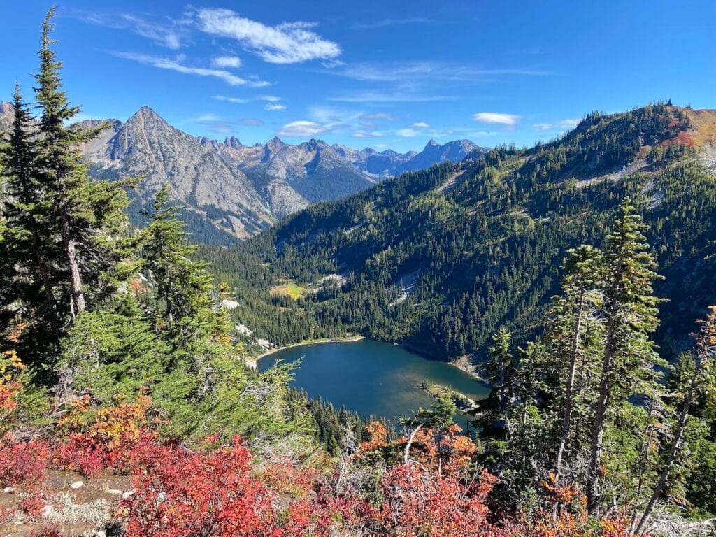
2. Maple Pass
- Round-trip distance: 6.6 miles roundtrip
- Elevation Gain: 2,145 feet
- Difficulty: Hard
Maple Pass is a stunning loop trail that offers incredible views of the North Cascades. Widely known for its gorgeous fall colors, this is a very popular hiking trail (also due to the easy trailhead access). Starting counter-clockwise, you will ascend gradually to a gorgeous meadow, filled with wildflowers in July and August or blanketed with the changing colors in September and October.
You will reach Heather Pass first, with gorgeous 360-degree mountain views and Lake Ann in the distance, then Maple Pass, before you begin your descent. The switchbacks from Maple Pass can be steep, so trekking poles are recommended.
Directions to the trailhead:
To get there from the west, drive east on State Route 20 to Rainy Pass. There is a parking lot on the righthand side of the road, but it is often full (unless you get an early start). Overflow parking is allowed on the side of SR 20.
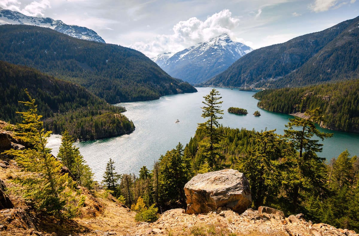
3. Thunder Creek to Fourth of July Pass
- Round-trip distance: 10.4 miles
- Elevation Gain: 2,200 feet
- Difficulty: Moderate-Difficult
This trail starts by skirting the shores of Diablo Lake. The lake waters are saturated with ‘glacier flour’ – the powdered rock created by the slow grind of moving glaciers. As a result of this mineral mix, Diablo’s waters glisten with a brilliant green hue.
From the lake, the trail winds up Thunder Creek Valley, meandering through an ancient forest of Western red cedar and Douglas fir. The fish-rich creek draws the attraction of lots of predators including otters and ospreys. And the rich forest ecosystem supports a host of animals, ranging from fishers and mink to mule deer and bears. But the birds will be the most common critters seen during a hike. Water dippers hunt aquatic insects while Northern flickers and downy woodpeckers drill for bugs in the standing timber.
At nearly 2 miles out, the trail crosses Thunder Creek on a stout bridge. An attractive camp on the far side of the bridge makes a great destination for backpackers looking for an easy outing to a pretty campsite. Continuing onward, the trail splits about a quarter-mile after crossing the bridge. Turn left and start climbing the Fourth of July Trail. The route winds upwards to the 5.2-mile mark at the crest of Fourth of July Pass, nestled between Ruby and Red Mountains. From here, enjoy stunning views across the valleys to either side, as well as west to Snowfield Peak and Colonial Peak.
Directions to the trailhead:
To get there from the west, drive east on State Route 20 to milepost 130, Colonial Creek Campground. Park in the lot nearest the boat ramp. The trail starts near the campground amphitheater.
4. Thunder Knob Trail
- Round-trip distance: 3.5 miles
- Elevation Gain: 400 feet
- Difficulty: Easy
Starting from a popular campground, this trail can be busy during peak summer months but come September, the crowds are gone and the fall colors are starting to pop – try to hit it then.
The route starts from the north side of Colonial Creek Campground. Cross the bridge toward the walk-in campsites, then follow the trail into the creek basin. The path runs across debris-strewn flood plains around the creek – the area experienced massive flooding in the early 2000s. Rock cairns mark the route across the rocky valley floor.
Once across the creek basin, the trail enters the forest with lots of alders, vine maple, and a few big-leaf maples scattered between the firs and cedars. These deciduous species present wonderful fall colors by mid-September.
After a mile or so of hiking, the trail swings around the butte and climbs through a forest clearing. Grand views start to open up here and as you climb, the views just get better. The trail ends atop Thunder Knob with panoramic views sweeping over the emerald waters of Diablo Lake and the snow-crowned peaks of the North Cascades, including Jack Mountain, Colonial Peak, Pyramid Peak, and Davis Peak.
Directions to the trailhead:
To get there from the west, drive east on State Route 20 to milepost 130, Colonial Creek Campground. Park in the lot nearest the boat ramp. The trail starts from the north side of Colonial Creek Campground.

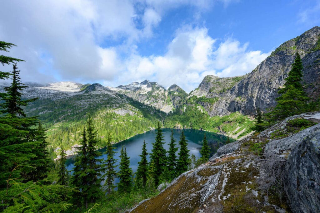
5. Pyramid Lake Trail
- Round-trip distance: 4.1 miles
- Elevation Gain: 1,500 feet
- Difficulty: Moderate
Although the lake at this trail’s end is scenic, the true payoff for this route comes during the entire hike. The trail pierces a healthy forest scarred by an old wildfire. Many of the towering Douglas firs along the lower stretch of the route feature blackened bark and limbs. There are also skeletal trees standing amongst the wounded trees. These standing dead snags collectively are known as a “silver forest” – named for their bleached white barkless trunks.
The trail climbs gradually to start, wandering through this fire-damaged forest until, at 1 mile, the route crosses a small stream and then climbs more steadily after that. On the forested slopes above the creek all the way to the small lake at the trail’s end, it’s common to see spruce grouse skittering around the underbrush near the water. The mixed growth forest also provides prime habitat for scores of other bird species and a number of four-legged critters. Keep an eye out for blacktail deer, pine martens, and a few different squirrel species.
The trail ends at Pyramid Lake, a small forest-lined lake nestled in a deep valley. The lake was formed by a massive rockslide (occurred centuries ago). The lake lacks fish since it was never stocked – virtually all fish populations in Washington’s Alpine lakes are the result of previous stocking activity. But although there are no fish, Pyramid Lake is far from lifeless. Numerous amphibians from frogs to salamanders thrive on the rich aquatic insect population.
Because the lake habitat hasn’t been altered by human intervention, the lake and surrounding forest have been designated a Research Natural Area where environmental scientists can study natural processes of all kinds. As a result of that designation, no camping is allowed in the lake basin.
Directions to the trailhead:
To get there from the west, drive east on State Route 20 to mile 126.8. Park on the north side of the road. The trailhead is found across the highway near Pyramid Creek.

6. Sourdough Mountain
- Round-trip distance: 12 miles
- Elevation Gain: 4,300 feet
- Difficulty: Strenuous-Difficult
Sourdough Mountain, home of a historic fire lookout tower, offers tremendous rewards for hikers but requires great effort to reap those rewards. This route is one of the most strenuous trails in the park, gaining nearly 1,000 per mile over the first four miles. The trail starts in low elevation forests, and climbs through an array of ecosystems, including old-growth temperate forest glades and subalpine forests, before climbing out into alpine meadows with outstanding panoramic vistas.
For 3.5 miles the trail climbs a seemingly endless series of switchbacks through rich forest habitat. A plethora of birds keep hikers company here as you slog up the steep slope. The pitch of the trail eases just a bit after the dense forest gives way to meadows and stands of subalpine forest. At 4.2 miles from the trailhead, the route accesses Sourdough Camp on the banks of Sourdough Creek. This is a wonderful camp from which it’s easy to climb to the summit for sunset/sunrise viewing. But day hikers should press on past the camp.
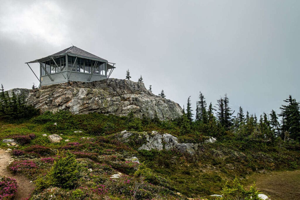
The trail crosses Sourdough Creek and over the next mile, rambles upward through subalpine meadows and granite gardens. At the crest of the ridge, the trail leads to the old defunct fire lookout cabin. The current cabin was built in 1933 though it was restored/refurbished in 1999. The original cabin was erected in 1917. The fact that this summit was used as a fire lookout for nearly 100 years is a testament to the stunning views the summit offers – soak in the scenic vistas that sweep from Diablo Lake far below to the glaciated summit of Mount Baker to the north.
NOTE: Camping is allowed in the area, but a backcountry camping permit is required. Details can be found on the North Cascades National Park website.
Directions to the trailhead:
To get there from the Puget Sound Region, drive east on State Route 20 to mile 126 and turn left, following signs to the town of Diablo. Park near the town’s domed swimming pool. The trail starts behind the swimming pool.
7. Cascade Pass Trail
- Round-trip distance: 7.5 miles
- Elevation Gain: 1,700 feet
- Difficulty: Moderate-difficult
The Cascade Pass Trail offers some of the best views from a trail in the park complex. The route climbs from start to finish, but all along the way, hikers enjoy views over the surrounding peaks and valleys.
The trail starts from the road end and climbs through a series of switchbacks through lush forest. After the first mile, the thick forest starts to open up, and views begin to open up more. The trail continues climbing, rolling upward into heather meadows and further upward into alpine meadows dotted with granite slabs and boulders. Here, you’ll find a rainbow of wildflowers throughout the summer months and a wide variety of wildlife. Gray jays and ravens are common overhead while pikas and marmots scurry through the rock gardens.
From the crest of Cascade Pass, enjoy views that sweep over Eldorado Peak, Johannesburg Mountain, Magic Peak, and McGregor Peak.
The trail continues past the pass for those seeking further adventures. Just over 2 miles further on, the trail accesses Sahale Glacier and the start of the rugged Ptarmigan Traverse cross-country route into Glacier Peak Wilderness.
NOTE: Camping is allowed in the area, but a backcountry camping permit is required. Details can be found on the North Cascades National Park website.
Directions to the trailhead:
To get there from the Puget Sound Region, drive east on State Route 20 to Marblemount and turn right onto the Cascade River Road. Continue 23 miles to the trailhead. Note that the Cascade River Road is only paved over the first third and is closed each autumn by snow. The road typically reopens by late June. Call ahead for road conditions.

If you’re looking for even more ideas for the best hikes to do in the North Cascades, check out Kristen’s trail guide to the Hidden Lake Trail, which is filled with a variety of amazing backdrops including sprawling wildflower-filled meadows, big granite rock slabs, and snowfields bursting with small tumbling waterfalls.
Have you done any of these best hikes in North Cascades National Park? Which ones are your favorite? Which ones are on your bucket list? Let us know in the comments!