6 Best Hikes Near Seattle, Washington
Discover the best hikes near Seattle from waterfalls to forests and mountain summits with this hiking guide – all within 2 hours of the city!

Seattle, Washington, is a hikers heaven. From waterfalls to mountain tops, the best hikes near Seattle take you deep into mossy forests or up onto rocky peaks. Plus, you are only a few hours from three different National Parks: Mount Rainier, North Cascades, and Olympic. With the Puget Sound on one side and mountains flanking the eastern skyline, there’s a hike for everyone around this lush PNW paradise.
Whether you live in the area or are just visiting, the hikes outlined in this guide are all within two hours of downtown Seattle (not accounting for traffic).
Looking for the best hikes near Seattle? Our Seattle hiking guide has you covered.
Important Reminder: As it goes in all of the destinations we share, please practice good trail etiquette and remember to Leave No Trace. This means packing out all of your garbage (including toilet paper), being respectful to others on busy trails, and following the established rules.
Seattle Hikes — Mapped
Best Seattle Day Hikes
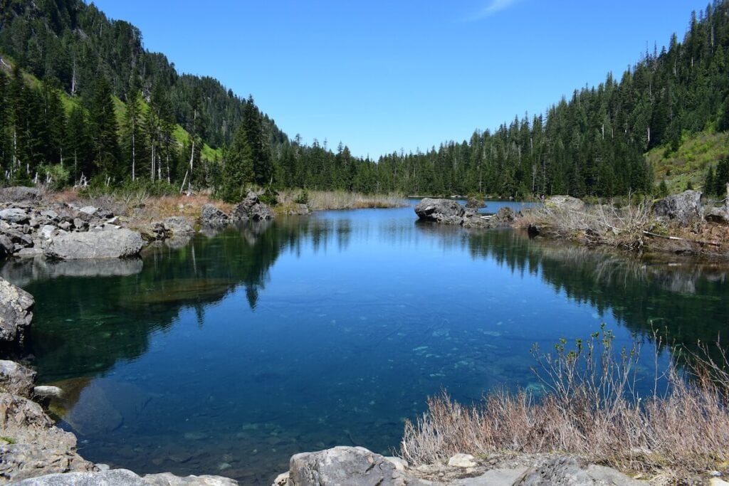
Lake Serene/Bridalveil Falls
- Distance: 7.5 miles
- Elevation Gain: 2690 feet
- Difficulty: Challenging
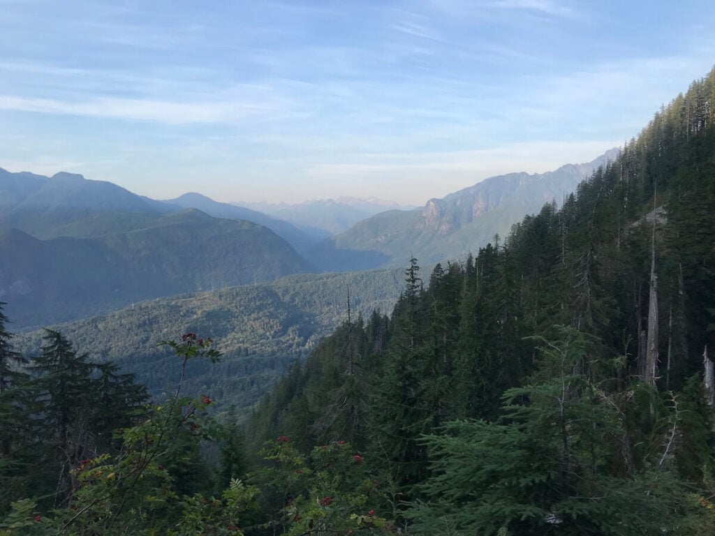
Hike to Lake Serene for a challenging uphill hike with views out over the Skykomish valley. The trail concludes at an alpine lake beneath the towering face of Mount Index. It’s worth a dip in the cool, clear water after the sweaty hike up!
The hike to Lake Serene includes an offshoot trail to Bridalveil Falls, one of the best waterfall hikes near Seattle. Water tumbles down the slick granite cliff, and if you squint, you can imagine the water flowing into a veil-like shape.
The trail begins on a road-grade gravel path that winds up through western red cedars and Douglas firs. About a mile and a half in, you reach the turnoff to head up to Bridalveil Falls. It’s only a half-mile up to the falls, but do this on the way to the lake. You won’t want to head back uphill on the way back! After the side trail to the falls, the trail turns into a jumble of roots and boulders. Watch your step as you begin heading up the switchbacks, up and up until you reach the lake. Stairs interspaced between sections of the trail provide a sense of relief from the uneven ground. As with all Seattle day hikes, be sure to pack a rain jacket in case the weather changes.
Getting There: Head north on I-5 to Everett and then take Highway 2 to Gold Bar. Turn right on Mount Index Dr and take the gravel road up to the trailhead. This parking lot fills up quickly on weekends, so make sure to arrive early to secure parking. The Forest Service requires an NW Forest Pass for parking.
Mount Pilchuck
- Distance: 5.2 miles
- Elevation Gain: 2122 feet
- Difficulty: Challenging
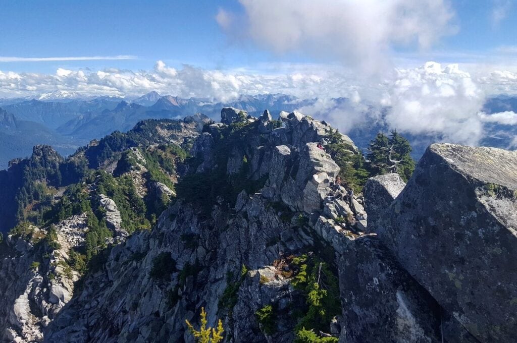
The only time I have hiked the trail to Mount Pilchuck was in the middle of winter, with multiple feet of snow on the ground. The trees bowed over with snow made the hike feel straight out of a Dr. Suess world. Although striking, I wouldn’t necessarily recommend this as a winter hike, as the trail passes under or through avalanche terrain, and other hazards abound during winter conditions. But during the summer, this is one of the best trails for mountain views in the Seattle area. The trail leads you to a fire lookout with 360-degree views, including Mount Baker and Mount Rainier. Built in 1921, the fire lookout is one of approximately 90 still standing in Washington today.
The remarkable views and short distance make Pilchuck a popular trail. The trail itself is steep and rocky, so it might not be great for someone with limited mobility. Some rocky, scrambly sections lead to the lookout, making for a great place to eat lunch. Or, this could be an easy overnight option with the possibility of either camping in the lookout tower itself or on a nearby grassy bench.
Getting There: Head north on I-5 until Everett and head east on the Mountain Loop Highway (WA-92). Take Forest Road 42 to the trailhead, but make sure to look up conditions as this road can be full of potholes and challenging to drive at times. The Forest Service requires an NW Forest Pass for parking.
Little Si
- Distance: 3.6 miles
- Elevation Gain: 1145 feet
- Difficulty: Moderate
For a quick afternoon jaunt to get outside and move, Little Si is high on the list of easy Seattle day hikes. This short hike right outside of Seattle climbs through classic PNW forests with views of Mount Si and the North Bend area. Known from the tv show Twin Peaks, Mount Si rises prominently over the valley below and makes for another great hike if you want something longer and steeper than Little Si. Many Seattleites use these two uphill trails as training hikes or runs for larger PNW objectives.
The Little Si trail winds its way through the forest with options to break off and add on mileage or join up with the longer Mount Si trail. To head to the summit of Little Si, continue until you reach the steep uphill section that leads you to views over the valley. On clear days, you can see Mount Washington and the summit of neighboring Mount Si. If you complete the Little Si hike and are ready for a challenge, try nearby I90 hiking staples like Mailbox Peak or Rattlesnake Ledge.
Getting There: Head east out of Seattle on I-90 until you reach the town of North Bend. The trailhead parking sits just north of the Middle Fork of the Snoqualmie River. Be aware that this parking lot does fill up quickly as this is a popular hike. Make sure to have a Washington Discover Pass for parking.

Lighthouse Point and Lottie Loop Trail
- Distance: ~2.5 miles
- Elevation Gain: 350 feet
- Difficulty: Easy
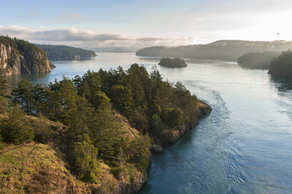
Although I love the Cascade Mountains, you can’t say you’ve spent time in the PNW without also spending time by the ocean. Deception Pass State Park is just north of Seattle near the small seaside town of Anacortes. The Lighthouse Point and Lottie Loop Trail contain options for length or direction as it includes two separate loops, both beginning at the parking lot for Bowman Bay. You could also head north towards Rosario Beach if you still want to hike more.
The trail follows the bay as it heads to Lighthouse Point, where you will get expansive views of the iconic Deception Pass bridge and Whidbey island. Then head back to the trail and either back to the parking lot or add on the small loop around Lottie Point. Many beaches along the route make for good spots to stop and eat lunch or hang out.
Getting There: Head north out of Seattle on I-5 until you reach Burlington. Then head west on Highway 20 toward Fidalgo Island and Anacortes but turn south to reach Deception Pass State Park. Park by Bowman Bay before the bridge onto Whidbey Island. Parking in the State Park does require a Washington Discover Pass.
Wallace Falls
- Distance: 5 miles
- Elevation Gain: 1482 feet
- Difficulty: Moderate
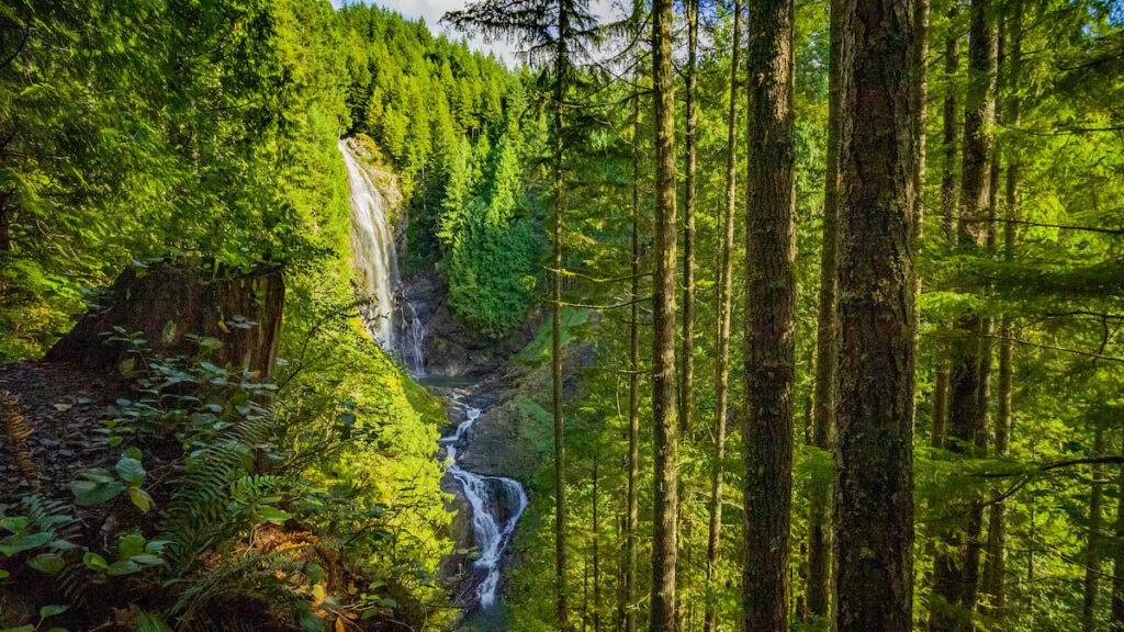
If you are looking for Pacific Northwest lushness, complete with waterfalls, ferns, towering hemlocks and cedars, and greenery galore, Wallace Falls is the hike for you. This Seattle hike follows the Woody Trail up the Wallace River to three stunning waterfalls.
The trail to the first waterfall is pretty moderate, with most of the elevation gain coming in between the Middle and Upper Falls. The Middle Falls overlook features arguably the best views with a birds-eye view of the falls and a panorama of the valley. Lots of nooks and benches by the river provide great places to take a break or eat lunch on the way up or back.
Getting There: Head north on I-5 to Everett and then head east on Highway 2 until you get to the small town of Gold Bar. There are signs on the highway to direct you towards Wallace Falls State Park, where you park in the main parking lot for the Woody Trail. Parking in the State Park requires a Washington Discover Pass.
Heather Lake
- Distance: 5 miles
- Elevation Gain: 1034 feet
- Difficulty: Easy/Moderate
The hike to Heather Lake is an excellent intro to alpine lake hiking near Seattle. The short distance does not include too much elevation gain but does provide some stellar views. Heather Lake is one of the best Seattle hikes for people who want to do more mountain hiking but don’t feel ready for some of the more challenging hikes in the area.
Located on the north side of Mount Pilchuck, Heather Lake is the destination, but the journey takes you through forests and across marshes. The trail winds up multiple switchbacks, as well as an old forest road. Some of the switchbacks have eroded, revealing roots and rocks, making walking challenging. If it has been recently raining (as it often is), this area may be slick, and little waterfalls might run down the trail. Be sure to read our guide on how to stay dry while hiking in the rain if the forecast calls for rain. At the top of the switchbacks, the trail evens out, and you will reach a fork that leads you in a loop around the lake.
Getting There: Pretty much the same as for Mount Pilchuck, head north on I-5 until Everett and head east on the Mountain Loop Highway (WA-92). Take Forest Road 42 to the Heather Lake trailhead signed on the left side of the road. The Forest Service requires a NW Forest Pass for parking.
What are your favorite Seattle day hikes? What is on your Seattle hiking bucket list? Leave us a comment below!
